
Maps have long been deployed as instruments of power, protest, and reform in American history. In the antebellum era, Northerners used maps to galvanize opposition to the expansion of slavery beyond the South. These dramatic and urgent anti-slavery maps served as powerful models for two of the most ambitious challenges to American law in the twentieth century: prohibition and woman’s suffrage. Both movements began with regional strengths—suffrage in the West, prohibition in the South. Suffragists and prohibitionists widely circulated maps to highlight those legislative achievements and thereby generate further momentum for their respective causes. After 1913, both the suffrage and prohibition movements pursued not just state-level campaigns but also federal amendments. In this context, maps became even more critical tools to establish and amplify support across the entire nation. A closer look at the common slogan of the two movements, “Make the Map All White,” reveals the degree to which both suffragists and prohibitionists navigated racial, ethnic, and geographical divisions in order to achieve their legislative and constitutional goals. Maps were at the heart of these strategies.
PDF: Schulten,* The Meaning of Maps in the Prohibition and Suffrage Campaigns.
Introduction: A Cartographic Coincidence
In December 1907, freelance journalist Bertha Damaris Knobe wrote a glowing account of the woman’s suffrage movement for Appleton’s Magazine.[1] As a suffragist herself, Knobe was well aware that the movement faced significant challenges. Since 1896, six states had considered—and rejected—woman suffrage, while a proposed federal amendment granting women the right to vote seemed to have little support.[2] Undaunted, Knobe decided to inject energy into the suffrage movement by highlighting not its failures, but its successes. In order to demonstrate that a “suffragists’ uprising was imminent,” Knobe detailed the growth of support for suffrage among various leaders and pointed toward recent gains in Europe.
To visualize the success of the suffrage movement in her article, Knobe drew a map that darkly shaded the four states where women enjoyed full voting rights, lightly shaded those of partial suffrage, and left unshaded the states where women enjoyed no access to the ballot.[3] As shown in Figure 1, Knobe’s map was enthusiastically received and widely reproduced by her fellow suffragists, for it translated a complicated legal landscape into an understandable picture. Moreover, it simultaneously documented women’s voting rights and argued for their extension. But Knobe’s map of suffrage rights also caught on for its ability to reframe a period of relative failure as a story of success, which in turn became a call to action.[4] Across the country, suffragists quickly began to create and distribute similar maps to advance state campaigns for voting rights. A string of suffrage victories after 1908 gave these maps greater currency. By the time suffragists shifted their attention from state campaigns to a federal amendment, these maps had become ubiquitous emblems for women’s rights; the phrase itself—that suffrage map—was fully woven into the American vernacular.[5]
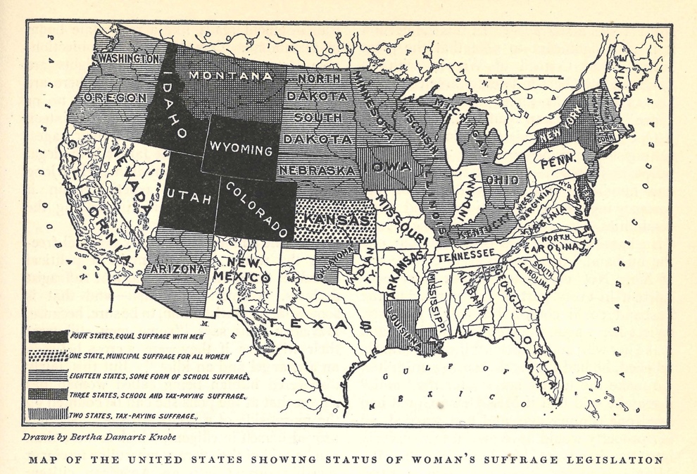
Figure 1: New York journalist Bertha Knobe designed this map in 1907 to create momentum for the suffrage movement by celebrating even limited voting rights. Soon suffragists would reverse the color scheme so that states with total voting rights for women were represented in white, not black.[6]
Just as Knobe was creating her map in 1907, a young woman north of Chicago was using a similar technique to measure the progress of temperance legislation across the country. On her massive map—reproduced as Figure 2—Mabel Dufford identified regions entirely under prohibition laws in white, then partially shaded those areas with limited alcohol restrictions. The darkly shaded areas were those operating under “license law,” meaning where liquor was still legal. Dufford’s shading scheme evoked the larger moral question at hand, for “wet” areas of the country had yet to be enlightened—and whitened on the map—by prohibition. She designed the map for the fall meeting of the Woman’s Christian Temperance Union (WCTU) in Denver, where it was ceremoniously unfurled on the stage and served as the backdrop for three days of impassioned speeches and mobilization.[7] Dufford even composed a song to accompany the map, celebrating victories from Texas to Maine in order to continue the fight to “Make the Map All White.”[8]
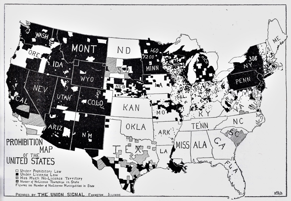
Figure 2: In 1908, anti-alcohol activist Mabel Dufford mapped the advent of liquor laws across the country to generate momentum for prohibition. Though the movement still remained a minor player in American politics, the map presents a story of progress in the effort to “Make the Map All White.” Courtesy of the WCTU Archives, Evanston, Illinois.[9]
At the turn of the twentieth century, both woman’s suffrage and prohibition were flagging movements, perceived as outside the mainstream of American political power. Suffragists and prohibitionists turned toward persuasive maps to advance their cause at the local, state, and federal levels. Both movements began by mapping local- and state-level legal victories, framing even small achievements as part of a larger pattern of success.[10] More specifically, these campaigns designed and constantly updated maps to translate the uneven and complicated legal landscape into clear and accessible visual narratives of progress, celebrating victories while reminding members of the work that remained to be done.
Maps designed to advance woman suffrage and prohibition became so common by the 1910s that even opponents adopted the language of maps to make their case. After 1913, both movements continued to use maps as they pursued ambitious federal legislation.[11] Both suffragists and prohibitionists achieved the ultimate victory of a constitutional amendment, leveraged at least in part by arguments that national sentiment had “tipped” in their favor. Maps served first to chronicle the small bore, local gains of these movements, and later to present a cumulative picture that framed the amendments as ever more realistic—even inevitable.
The two movements also overlapped in membership and goals: prohibitionists were among the first supporters of woman suffrage,[12] and many suffragists sought the right to vote in order to advance prohibition.[13] Both reforms moved from the margins to the mainstream of American political culture by adopting savvy, assertive, and persuasive strategies after the turn of the century.[14] Maps were at the heart of these new approaches. A closer look at these maps also reveals the complexity behind the slogan used by both movements: Make the Map All White. On one level, it was a call to extend prohibition and women’s suffrage from coast to coast. Yet it also reveals the degree to which these movements were designed by—and for—a particular race and class.
This Article explores the geographical, rhetorical, and political strategies of the prohibition and suffrage campaigns, with particular attention to their use of maps. Part I examines the nineteenth-century use of persuasive maps to oppose the extension of slavery into the American West. After briefly noting the use of these maps to oppose lynching, this Article traces the adoption of similar visual strategies in the prohibition and suffrage campaigns in Parts II and III, respectively. By the 1910s, both suffragists and prohibitionists relied on maps to advance legislation at the state and federal levels. Seen from another angle, these maps also reveal the ways that these movements aimed to not only challenge but also entrench hierarchies of class, race, and ethnicity.
I. Opposition to Slavery and Lynching
The explosion of map use among early twentieth-century social reformers grew out of a significant expansion of map design and use in the nineteenth century. By the 1830s, maps were no longer primarily wayfinding aids or representations of the physical environment. Instead, maps routinely appeared as tools of investigation,[15] modes of communication,[16] and fixtures of education[17] across multiple areas of European and American life. Whether used to trace the source of yellow fever or to identify patterns of crime, maps became common ways to explore causation and distribution.[18] The advent of less expensive print technologies further aided this shift. Though maps have long been tools of power and persuasion, they became far more common in the nineteenth century.[19]
In the United States, one of the boldest uses of persuasive mapping emerged from the crisis around slavery in the 1830s. Though Mexico had outlawed slavery in what was then its northern province of “Tejas,” the revolution and subsequent independence of the Texas Republic—driven by Anglo-American slaveholders who had settled there in the 1820s—raised the possibility that a new slave state would be added to the Union.[20] In response, abolitionist Julius Ruben Ames designed the starkly colored “moral map” shown in Figure 3 to oppose the possible annexation of Texas by the United States. Ames darkened the slave states on the map to protest what he saw as the westward expansion of slavery.[21] This shading completely rejected the prevailing ethos of Manifest Destiny, which celebrated the nation’s territorial growth as foreordained, if not divinely inspired. Instead, Ames provocatively presented a nation at odds with itself. This dramatic, foreboding picture of a divided country anticipated the anger of Northerners in the 1840s, who believed that the war against Mexico in 1846–1848 was waged primarily to extend the territorial reach—and political power—of southern slaveholders.[22]
Ames’s tract was frequently reprinted,[23] but consistent opposition to slavery remained limited to the relatively small community of abolitionists until the 1850s. In January 1854, Senator Stephen Douglas introduced a bill to open the remaining lands of the Louisiana Purchase to settlement.[24] Because these lands lay north of the Missouri Compromise Line, they would be legally closed to slavery; to gain southern support for his bill, Douglas included language whereby the status of slavery in these new territories would be determined by “popular sovereignty.”[25] This prompted a sectional crisis that consumed the nation, for Douglas had effectively opened the possibility that new territories would permit slavery where it had been prohibited for over thirty years.

Figure 3: This 1837 map captured the fear and anger among abolitionists regarding the westward expansion of slavery, particularly with the recent independence of Texas and its anticipated annexation by the United States. Courtesy of Cornell University—PJ Mode Collection of Persuasive Cartography.[26]
Days after Douglas introduced the bill, thousands of New Yorkers who might otherwise have been indifferent to slavery gathered with urgency at the Broadway Tabernacle.[27] At that protest meeting, mapmaker George Colton unfurled an enormous map to capture the crisis posed by the Kansas-Nebraska bill. The map shaded all interior territories to suggest a sickening future where slavery reached into the West. In other words, the threat of slavery was no longer confined to the South but now extended into areas long assumed to be entirely free. Colton quickly adapted his large map for newspapers and pamphlets, as shown in Figure 4, which appeared in The Independent, a New York anti-slavery publication.[28] At the Broadway Tabernacle meeting, outraged speakers invoked the map to galvanize opposition to Douglas’s betrayal of the longstanding Missouri Compromise.[29]
This map dramatized—and maximized—the threat of slavery in the interior West, sending an electrifying message that shocked northern readers into opposing the Kansas-Nebraska bill.[30] Though variations exist, these maps of 1854 always identified slavery as an expansive force, one that encircled, dwarfed, and ultimately threatened the free states of the Northeast. Moreover, the black shading amplified the menace of the “slave power conspiracy,” language used to suggest that southerners dominated the machinery of government and would use that power to extend slavery. The black shading also underscored the racial dimension of slavery itself. Drawn hastily and rarely to scale, the maps urgently conveyed to both literate and semi-literate readers the threat that southern slavery posed to northerners. For the next two years, the prospect of slavery in the Kansas Territory fueled tensions that threatened the unity of both the Democrats and Whigs. Opposition to the Kansas-Nebraska Act (passed in May 1854) led to the birth of the Republican Party, organized on the principle that Congress had not only the right but the obligation to outlaw slavery in the western territories.[31]
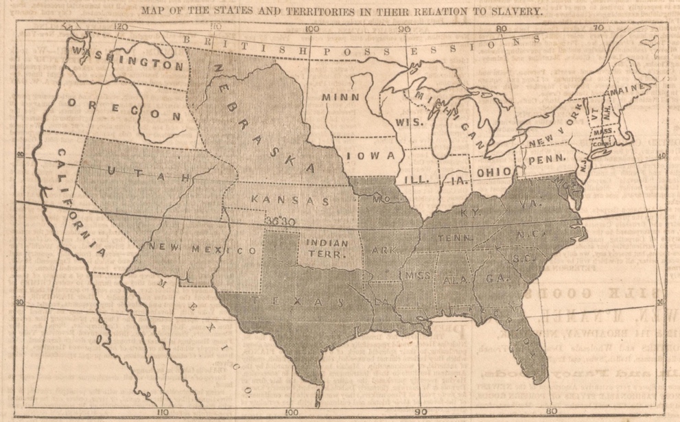
Figure 4: In January 1854, the Kansas-Nebraska bill introduced the possibility of slavery in the western territories, prompting tremendous backlash and anger. In response, this March 1854 newspaper map dramatized that issue to galvanize opposition to the bill. Courtesy of the Library of Congress.[32]
Given the importance of the Kansas-Nebraska Act, it makes sense that the Republican Party relied on maps in its first presidential campaign of 1856. In pamphlets and broadsides,[33] maps were used to translate the complex arrangements of the Act into a clear and powerful message: slavery posed a threat not primarily to southern Blacks, but to northern Whites.[34] In many of these political maps, the West is blackened entirely, indicating the fear that it would soon be impossible to limit slavery anywhere in the West. The maps raised the prospect not just of slavery, but the specter of Black people in the West. This added even more power to the color scheme that shaded slavery as an ongoing, expanding threat to a West of free, White settlement.[35] Little wonder, then, that in 1856 the Republican Party nominated John Fremont for president. Fremont was then the most celebrated explorer of the American West, symbolizing not just the spirit of American expansion but also the Republican Party’s mission to keep these new territories free of slavery.
Though Fremont lost to the Democrat James Buchanan in 1856, within four years the nation elected Republican Abraham Lincoln on a platform that remained dedicated to limiting the growth of slavery. Yet the abolition of slavery in the ensuing Civil War left open the fundamental question of what was to follow. Lincoln’s own mild proposal stressed swift reunification without reforming the South’s labor or racial structures. Lincoln’s assassination brought Andrew Johnson to power, a man even less committed to civil rights for the freedmen. Within months of Confederate surrender at Appomattox, southern Whites had restored a rigid racial hierarchy through legal and extralegal means that controlled every aspect of Black life. President Johnson responded with indifference.
The failure of Presidential Reconstruction under Johnson emboldened the Radical Republicans in Congress to draft the Fourteenth and Fifteenth Amendments after the election of 1866.[36] The Fourteenth Amendment enshrined citizenship rights for Black men,[37] while the Fifteenth guaranteed male voting rights.[38] Designed to protect African Americans from disfranchisement, discrimination, and violence, the amendments were circumvented for the next century.
One measure of that extreme repression was the explosion of lynching after Reconstruction. In the early 1880s most victims of lynching were White and located in the West, yet within a decade they were almost exclusively Black and southern.[39] And yet, despite its increasingly racist and brutal character, lynching drew little outrage at the height of the Jim Crow era.[40] In response, Ida B. Wells called attention to this phenomenon in her books Southern Horrors and A Red Record. In those studies, Wells challenged the myth that lynching was a response to accusations of rape by documenting these accusations as justifications for the murder of Black people.[41] At the founding meeting of the National Association for the Advancement of Colored People (NAACP) in 1909, Wells again stressed that lynching was a uniquely racist crime that rarely stemmed from allegations of sexual assault.[42] She noted that states and localities almost never prosecuted these murders. Such indifference led her to insist that lynching be made a federal crime, and that the federal government actively intervene to protect rights of citizenship that had been so openly disregarded across the South.[43]
In that speech, Wells also called for the NAACP to document the history of lynching so it could be better understood, publicized, and ultimately prosecuted.[44] Her idea bore results, but only after the vicious lynching of Jesse Washington in Texas drew thousands of onlookers in 1916.[45] This “Waco Horror” prompted the NAACP to investigate the history of lynching across the country starting in the 1880s.[46] Published in April 1919, Thirty Years of Lynching carefully catalogued these murders without embellishment in order to avoid any claims of sensationalism that might delegitimize the findings.[47] The report bore out the observations that Wells had made years earlier: lynching rarely resulted from even an accusation (much less a trial or conviction) of rape, indicating that this was primarily a racial form of violence.[48]
The NAACP’s report was published as Congress was considering the Dyer Bill, which proposed to make lynching a federal crime.[49] President Wilson, though expressing concern about this injustice, considered lynching a matter for the states rather than the federal government.[50] Wilson’s reluctance to intervene may have influenced the authors’ decision to open their study with two striking maps that made the racial and regional character of lynching undeniable. First came Figure 5, which mapped the patterns of lynching from 1889 to 1918. That map demonstrated that the vast majority of these crimes were committed in the former slave states of the South. The authors chose to entirely blacken those states where over one hundred lynchings had occurred, generating a stunning picture of regional injustice that heightened the urgency of the Dyer Bill.
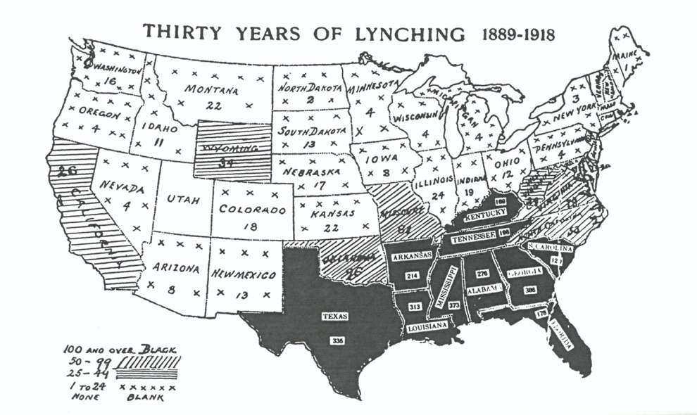
Figure 5: In the spring of 1919, the NAACP used maps to argue that lynching was primarily used to terrorize African Americans in the former slave states. These maps were issued as Congress was considering the federal anti-lynching Dyer Bill, which later failed.[51]
Given the dispassionate approach of the NAACP report, the map was even more important, for it identified the geographical and racial patterns that would have been lost in the catalog of statistics that followed. The stark shading of the map drove home the relationship between the past and the present, demonstrating that the grim legacy of slavery remained alive across the American South. NAACP Secretary John Shillady noted that sixty-three Blacks had been lynched in 1918 alone, and not a single one of these crimes had led to a conviction.
To drive home the point that lynching remained a particularly southern problem, the authors presented a second map that focused solely on crimes committed in the prior decade, from 1909 to 1918. With this second map, viewers could scarcely deny that unprosecuted lynchings continued to plague the Deep South, with the highest rates of murder in Georgia and Texas. In the 1850s, the fledgling Republican Party used maps to highlight the threat posed by the expansion of southern slavery to the nation and thereby galvanized support for its cause. Over half a century later, the NAACP mapped the incidence of lynching over three decades in order to demonstrate to the entire nation the uniquely anti-Black and southern character of these murders. Such clarity, the NAACP hoped, would demonstrate that lynching demanded federal action. The NAACP maps translated research into an argument in order to persuade the public.[52] But just as the study was published in the spring of 1919, race riots broke out across dozens of cities across the country, demonstrating the degree to which this “southern problem” plagued the entire nation.
II. From Temperance to Prohibition
The birth of the NAACP occurred during a wave of reform across the United States, loosely characterized as the Progressive Era. Among the most organized of these reform movements was prohibition, or the aim to control—if not eliminate—the consumption of alcohol. Though it reached its greatest success in the Eighteenth Amendment, the origins of prohibition lay a century earlier, in the antebellum religious revival that produced a nationwide temperance movement.[53] The essence of that antebellum campaign was one of voluntary conversion, which aimed to convince millions of Americans to pledge lifelong abstinence.[54] That campaign also sought to regulate alcohol production, but this goal was secondary to the focus on voluntary self-control and the reform of individual behavior.[55]
After the Civil War, temperance sentiment flourished again, and though it remained deeply evangelical in nature, it was now driven more by the belief that alcohol was an especially urban problem. This postwar opposition to alcohol was also led less by churches than by organizations dedicated entirely to controlling the production and sale of alcohol itself. The founding of the Prohibition Party in 1869 and the birth of the WCTU in 1874 signaled this new phase of temperance, one less interested in extracting voluntary promises of abstinence than in eliminating what the activists considered to be the locus of the problem: the urban saloon. Emblematic of this shift was the founding of the Anti-Saloon League in 1893, its name reflecting the goal of controlling the liquor industry as well as demanding individual moral improvement.[56]
This second wave of anti-alcohol reform—highly disciplined, focused on legislation, and national in scope—liberally used visual techniques to frame alcohol as a problem endemic to the city. A representative example of this outlook can be found in Robert Graham’s Liquordom in New York City. Graham stressed the evil nature of the liquor industry and the threat it posed to Christian civilization. But he also mapped the location of saloons in order to make an empirical argument about the need to regulate alcohol rather than rely on voluntary pledges of abstinence.[57] Henry William Blair, a Republican Senator from New Hampshire and an ardent prohibitionist, similarly mapped the distribution of liquor licenses in New York City in 1886[58] in order to showcase “regions of despair” within the city.[59]
In the same decade, the Reverend G.W. Gray asked readers of the Union Signal (the national newspaper of the WCTU), to submit local information about where liquor was sold, crimes were committed, and deaths were attributable to alcohol.[60] His goal was to integrate that information on a map in order to advance support for temperance.[61] Gray, Blair, and Graham all used maps to frame the problem of the saloon in an ostensibly neutral manner.
These examples reflect the way that late nineteenth-century temperance reformers took cues from the emerging fields and techniques of social science to present their agenda to both their members and the public. The WCTU was fully invested in this approach, framing its goals not only in terms of voluntary action and moral purity but also the regulation of liquor sales and the institutionalization of anti-alcohol education. In 1879, Frances Willard became the president of the WCTU, and within a year she had been persuaded by Mary Hanchett Hunt to pursue mandatory anti-alcohol curricula across the country. Hunt’s goal was to convert the next generation to the cause of temperance, which she did by creating the Department of Scientific Instruction within the WCTU.[62] Hunt aggressively promoted anti-alcohol education and was responsible for introducing these materials in half of the nation’s public schools.[63]
By the turn of the century, Hunt had become one of the most influential women in the country and among the greatest advocates for prohibition.[64] To expand anti-alcohol education, she encouraged WCTU chapters to report how these school initiatives were enforced. Hunt then compiled this information from local chapters onto a map in order to create a national “scorecard” of temperance education across the country.[65] Her visual scheme reflected her own moral convictions: areas of compliance with temperance education were marked in white, while areas of partial or non-enforcement were darkened to indicate work to be done. The challenge, she wrote, was to press temperance into the schools until the “whole map [was] marked F.E.” (fully enforced) and represented in white.[66] Dark spaces were problems to be solved, areas to be (en)lightened. As she put it, while states in white had temperance education, “[t]hose in Black have NONE.”[67]
Though Hunt’s contemporaries criticized her extreme claims about the dangers of alcohol, her decision to map the legal status of temperance education resonated with many in the WCTU.[68] To commemorate each new state adopting temperance education, Hunt had WCTU members symbolically remove a black cloth from their state map to reveal the white base underneath.[69] This ritual was followed by entreaties to continue monitoring the enforcement of curricular initiatives in these now-whitened districts.[70] By darkening geographical spaces without temperance education, Hunt laid the foundation for the subsequent prohibition slogan to “make the map all white.” And, by marking any instance of temperance education on the map, she shrewdly highlighted evidence of progress in order to generate momentum for the movement.[71] Her map was simultaneously a record and an aspiration. Like the earlier saloon maps, Hunt’s temperance education map both captured the state of play across a given geography and deployed that image to galvanize further action: it mapped what was as well as what should be.
Hunt’s scheme and map became central to the WCTU mission of advancing temperance education. By 1902, the organization celebrated a “jubilee,” for temperance education had been adopted in every state of the Union.[72] As Hunt herself put it on that occasion, the “only blot upon the now unsullied purity of our Temperance Educational Map” had been “wiped away.”[73] The WCTU report for that year underscores the meaning of maps for the movement. The “white map” was not just a tool but a reflection of the WCTU’s divine mission to restore national purity.[74] As one 1892 WCTU report argued, “[t]he best prayer book is a map of the world.”[75] In other words, the temperance movement sought to reach new regions and populations. Hunt’s technique resonated with the many members who invoked the “white map” as a metaphor for temperance.
In service to temperance, both the Prohibition Party and the WCTU openly endorsed woman’s suffrage in the late nineteenth century. Willard believed prohibition would come only through the vote,[76] and the WCTU even created a “Franchise Department” in 1881 to advance woman’s suffrage.[77] Willard was close to Susan B. Anthony, a leading suffragist, and many leaders in the suffrage movement came from the WCTU.[78] Anticipating resistance in the South and Northeast, however, Willard carefully framed female voting through the gendered appeal of “home protection.”[79] The WCTU invested heavily in suffrage in the 1890s at the municipal and state levels; by 1909, thirty-seven of the forty-five states with active chapters had Franchise Departments,[80] though suffrage was always a means to achieve temperance.[81] As the WCTU Report for 1910 put it, “[r]epeated attempts to make ‘the map all white,’ force us to demand more power for our sex.”[82]
Despite the limited unity between these two movements, no statewide temperance laws were passed from 1889 to 1906, a result of the waning influence of the WCTU, the narrow appeal of the Prohibition Party, and the organizational and financial problems facing the Anti-Saloon League. Yet significant progress was made through local option laws, and by 1906 forty percent of the national population was living under some kind of dry legislation.[83] Thereafter, the revival of temperance sentiment led to a limited string of statewide alcohol regulations from 1907 to 1909.[84] As C. Vann Woodward observed, until 1907 there had been no statewide prohibition across the South.[85] That summer, however, Georgia passed a strict prohibition law that prompted similar legislation in Oklahoma, Alabama, Mississippi, North Carolina, and Tennessee by early 1909.[86] Having long relied on local efforts to control liquor, these five states now embraced a more comprehensive legislative approach that in turn stimulated the national conversation around prohibition.[87]
Some historians have suggested that this wave of prohibition laws across the South was achieved through naked appeals to anti-Black racism. Others have complicated this assertion, arguing that prohibition initiatives were largely driven by middle class concerns about poor Whites as well as Blacks. Yet it is certainly the case that prohibitionists considered the “Black vote” in the South to be manipulated by the liquor industry. Outside of the South, prohibitionists had long suggested that the brewing industry had close ties to urban ethnic voters, and Willard herself expressed concern about “alien illiterates” and the political power they wielded in American cities.[88]
This context is relevant in two ways. First, the prohibition movement eyed the nation’s increasingly diverse cities as obstacles to their goal of a country free of alcohol. And, more immediately, it was in the midst of these southern prohibition victories that assistant editor of the Union Signal, Mabel Dufford, created her popular prohibition map seen in Figure 2.[89] Inspired by Mary Hunt, local WCTU chapters had long designed maps to profile the progress of temperance education and legislation in their home states. These maps were adaptable and useful tools, and the WCTU considered them “a revelation and inspiration.”[90] These existing efforts—as well as the racial and ethnic context of these prohibition campaigns at the turn of the century—no doubt influenced Dufford as she visualized the WCTU effort to “make the map all white” in 1908.
As mentioned above, Dufford mapped all victories—from statewide bans to local option laws—in order to build momentum for the movement. Her map was unveiled at the Denver meeting of the WCTU in October 1906, as seen in Figure 6. This use of the map to rally support echoes the way the original map of the Kansas-Nebraska Act and its threat to the American West was unfurled at the Brooklyn Tabernacle in January 1854.[91] Featured under a banner claiming, “The Nation’s Going Dry,” Dufford’s map suggested substantial regional progress across the South and Midwest. In fact, after the initial wave of southern victories, prohibition actually lost ground at both the local and state levels across the country, including in the South.[92]
It is this fluid context that made Dufford’s map so meaningful, for it translated an immensely complicated and dynamic legal landscape into a clear visual scorecard that bolstered the movement. In other words, the map recorded temperance achievements (rather than focusing on defeats), then capitalized on those laws in order to create momentum for national prohibition. The WCTU circulated Dufford’s “herculean” cartographic achievement on postcards and in Sunday Schools, and made the map inexpensively available to members over the next decade.[93] Her map also hung in the WCTU president’s home, so that visitors could watch “that historic map grow from ‘black’ to ‘white.’”[94] Just as the initial anti-slavery map of 1854 was simple enough to reproduce, Dufford’s map was easily replicated by local chapters, and could be constantly updated to chronicle the advance of prohibition.[95]
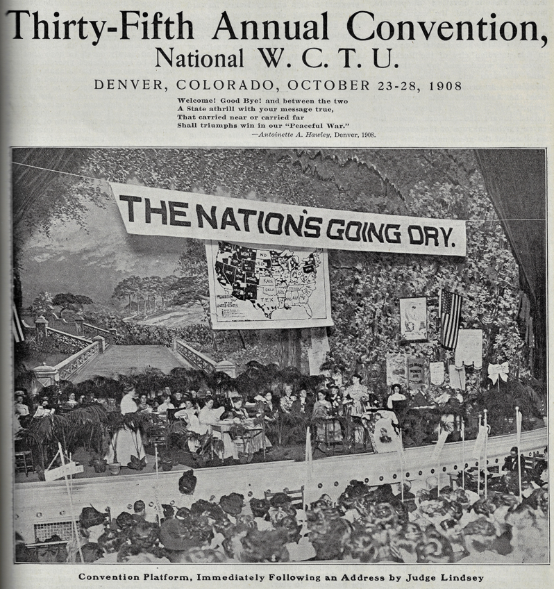
Figure 6: The “Prohibition Map” made its dramatic debut at the October 1908 meeting of the WCTU in Denver. At that same meeting Mabel Dufford introduced a companion song to rally the movement, “Make the Map All White.” Courtesy of the WCTU Archives, Evanston, Illinois.[96]
The WCTU encouraged members to “use the prohibition map everywhere” because “it is an effective lesson.”[97] To drive that lesson home, Dufford also wrote a song that narrated the spatial growth of temperance across the country, “Make the Map All White.” The lyrics point to the geographical success of prohibition in rural and southern states with comparatively small urban or immigrant populations. Even there, however, Dufford slightly exaggerated the march of prohibition; Texas, for instance, had actually defeated recent dry measures yet it appeared as a victory for prohibition. Members ended each stanza with a rousing promise that “We’ll work for prohibition ‘till we make the map all white.”[98] To make the map “all white” underscored both the nativism and racism of the modern prohibition movement, as well as the desire to purify not just oneself but others. The song and map became staples of WCTU and the World’s Woman’s Christian Temperance Union meetings.[99]
Just after Dufford composed her prohibition map and song, the Anti-Saloon League (ASL) began to issue temperance maps along the same lines. After 1909 the ASL’s annual yearbook mapped the fluid status of legislation across each state by shading those counties that remained wet, as Dufford had done.[100] By mimicking her scheme, the ASL created a compelling visual binary—the darkened regions under license law signaled problems that had yet to be solved while whitened territory marked gains for prohibition. As with the WCTU, the ASL maps served both as a status report and an organizational tool. These “wet-dry” maps, seen in Figure 7, were the ideal way for the ASL and the WCTU to maintain an image of ongoing success by chronicling and publicizing any alcohol regulations.[101] And by identifying territorial regions under prohibition law—which had lower populations than cities that traditionally resisted the regulation of alcohol—the geographical strength of the movement was exaggerated. This visual strategy that emphasized area over population enabled the movement to showcase temperance gains and minimize its losses.
Figure 7: The Anti-Saloon League published “wet-dry” maps of the states, such as this one from 1911. These maps became staples of the movement, snapshots of progress made and challenges that remained.[102]
Recognizing the importance of these persuasive materials, the ASL established its own publishing house in 1910.[103] Located in Westerville, Ohio, the American Issue Publishing Company made thousands of state and national prohibition maps freely available to local and state temperance groups. The company was led by the single-minded Ernest Cherrington, who shared the League’s aggressive focus on defeating the liquor lobby. Cherrington understood the importance of keeping the issue in the news as much as possible, inundating newspapers and organizations with persuasive literature. But prohibition also benefited from the reformist energy that was sweeping the nation, garnering endorsements in 1912 from suffragists Jane Addams and Elizabeth Tilton, labor leader Samuel Gompers, and juvenile justice reformer Benjamin Lindsay.[104]
In this moment of nationwide attention to prohibition, the ASL made a crucial change to its strategy. For years the movement had pressed for state and local liquor laws.[105] In 1913, the ASL’s Wayne Wheeler set a much more direct and unilateral goal by introducing a constitutional amendment to prohibit the production and sale of alcohol across the country.[106] As Daniel Okrent has observed, the recent establishment of a national income tax through the Sixteenth Amendment had crucial implications for congressional consideration of prohibition. With this amendment, the federal government no longer depended upon the revenues that were historically generated through the sale of alcohol.[107] The time was right, in other words, to strike for a constitutional amendment that would govern the entire nation.
The ASL and the WCTU symbolically delivered a petition requesting a federal prohibition amendment in a dramatic procession to Capitol Hill just before Christmas 1913.[108] Cherrington believed that this new constitutional strategy would garner even greater media attention and—by extension—public support.[109] To that end he published tens of thousands of pamphlets, leaflets, window cards, meeting tickets, door hangers, and postcards that featured wet-dry maps to suggest that support for temperance was growing across the country.[110] And by using those maps to measure the reach of dry laws over territory rather than over population, the ASL maximized—even exaggerated—the extent of the campaign’s success.
From 1914 to 1916, while the ASL leaders focused on the constitutional amendment, seventeen states moved to the dry column.[111] Wet-dry maps were central in this campaign, used in public rallies, newspapers, and Sunday school lessons to awaken youthful attention to temperance.[112] Cherrington’s publishing efforts had made prohibition maps so ubiquitous that many newspapers and pamphlets referred to “wet” or “dry” areas “on the map” as shorthand for the progress of the movement, even without reproducing a map.[113] Moreover, the practice of using maps to measure the progress of prohibition was so common that it inspired a backlash. In 1916, for instance, the National Wholesale Liquor Dealers Association of America published The Anti-Prohibition Manual, which pointed out the misleading nature of the ASL’s prohibition maps.[114] Cherrington could not have had better evidence that his visual propaganda was being noticed.[115]
The initial prohibition amendment—introduced by Senator Richmond Hobson—failed to earn two-thirds support in the House of Representatives at the end of 1914.[116] But a majority in the House had voted in favor, which fueled the hopes of prohibition reformers across the country. Moreover, individual states were embracing prohibition far quicker than woman suffrage over the course of the 1910s.[117] The failure of the amendment in 1914 also introduced a sense of urgency into the movement, for many prohibitionists anticipated that redistricting after the 1920 Census would make it nearly impossible to overcome the power of urban areas.[118] In 1910, city dwellers accounted for 46 percent of the national population. As Senator Hobson wrote to Cherrington in March 1915, if the amendment was to succeed it had to pass in the next congressional session. High birthrates among immigrants, continued immigration, and domestic migration to cities meant that the urban population would almost certainly constitute a majority by the next census.[119]
Prohibitionists believed that these immigration and urbanization patterns threatened their national and cultural heritage. Temperance reform was rooted in evangelical churches, and this association gave the term “white” some of its resonance: temperance was a pathway to purity, redemption, and salvation.[120] But the term also reflected the nativist and anti-Black outlook of the ASL and the WCTU. Both organizations regarded the country’s White Protestant heritage as under siege by an increasingly non-White, non-native born, and non-Protestant population. As Lisa McGirr and others have shown, the rebirth of the Klan in 1915—especially in the Midwest and the West—grew from this sense of embattlement.
The public face of the Klan was one of Christian morality, aligning closely with prohibition and openly hostile to Catholics, Jews, and African Americans. After the ratification of the Eighteenth Amendment, the Klan’s membership surged, drawing heavily from the ranks of prohibition organizations––such as the ASL and the WCTU––which had traditionally seen immigrants and cities as a threat. For instance, two of the chief promoters of the second wave of the Ku Klux Klan in the 1920s were former fundraisers for the ASL.[121] The Klan was even willing to endorse women’s suffrage in areas where the members shared common goals such as prohibition.[122] In turn, the Klan acted as a kind of citizens’ brigade enforcing the Eighteenth Amendment, often through extralegal means.[123] In 1923, the WCTU even called for non-citizens convicted of violating prohibition to be deported, fighting to “make the map all white” even after ratification.[124]
Seen in this light, the ASL’s decision to prioritize a constitutional amendment after 1913 gave new meaning to the slogan, “make the map all white.” As the ASL argued by 1915, a subset of states could pass and then ratify a prohibition amendment that would govern the entire population. To drive home that point, the ASL engineered a second slogan shown in Figure 8: “Thirty-six states can do it.”[125] Such a refrain implied that the longstanding resistance to prohibition in the remaining states—which were higher in immigrant, urban, and non-White populations—could be overcome. This pivot toward a constitutional amendment also gave the prohibition map new relevance, for this strategy leveraged the relative power of the smaller rural states in the Senate—many of which had gone dry—against the heavy saloon territory of the six states with the nation’s largest cities.[126]
In this context, to “Make the Map All White” no longer meant pursuing laws that reflected local preference and regional custom, but rather imposing a draconian, permanent, nationwide law engineered by White, evangelical Protestants. Note the language used by the ASL to frame the problem: though forty-seven million Americans lived under Prohibition, and seventy-one percent of the national geography was governed by the same (a fact underscored by the map), it was the sizable minority in cities that constituted the obstacle. If only thirty-six states banded together, the problem of urban saloons could be solved. The map gave prohibition a degree of legitimacy by making it appear to enjoy wide—even nationwide—support.
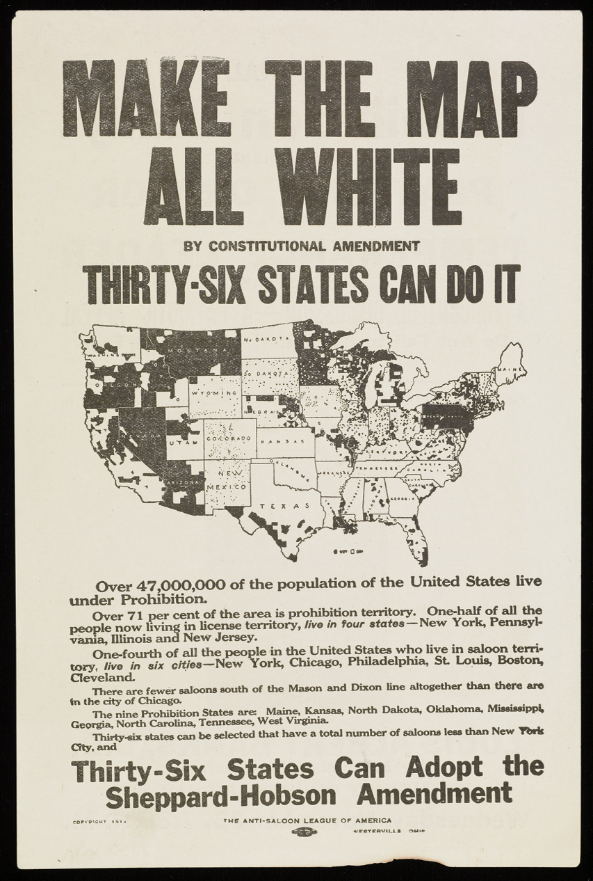
Figure 8: This Anti-Saloon League broadside was used to advertise a 1914 temperance rally in Richmond, Virginia, just after the introduction of the constitutional amendment. Note the message that thirty-six states—many predominantly rural—had the power to create a law governing the entire nation. Courtesy of the Albert and Shirley Small Special Collections Library, University of Virginia.[127]
That goal of presenting prohibition as a national movement is also apparent in Figure 9, the cover of a prohibition pamphlet distributed by the ASL in 1916.[128] “Thirty-six States Can Do It” reminded supporters that, in fact, only a marginal increase in support was needed to achieve the constitutional amendment. Equally significant is the name of the organization sponsoring the pamphlet—the “Lincoln-Lee Legion”—which invoked the former president as not only a hero of the Union cause, but also a lifelong teetotaler.
The Lincoln Legion was originally organized in 1903 by Howard Hyde Russell, one of the founders of the ASL, for young people willing to pledge abstinence from alcohol.[129] But Lincoln’s name was not uncontroversial in the South, and in 1912 the ASL renamed the group in acknowledgement of Robert E. Lee’s abstinence. The name “Lincoln-Lee Legion” reveals the national ambitions of the prohibition movement as it sought a federal amendment. This decision also signaled the ongoing reconciliation between White Northerners and Southerners after the Civil War. In the first few decades of the twentieth century, White Southerners erected hundreds of memorials and monuments to Confederate leaders—including Lee—in order to assert white supremacy.[130] This elevation of the “Lost Cause” through this naming and memorialization was the cultural and symbolic counterpart to the simultaneous growth of lynching and legal segregation. By renaming the organization the “Lincoln-Lee Legion,” the ASL acknowledged that the movement for national prohibition found its strongest and earliest support among White Southerners. The strange juxtaposition of “Lincoln” with “Lee”—and the self-identification of legion members as “Patriots” despite Lee’s traitorous subversion of the Union—also highlights the degree to which White Americans sought reconciliation in the early twentieth century, even at the expense of Black Americans’ rights and freedoms.[131]
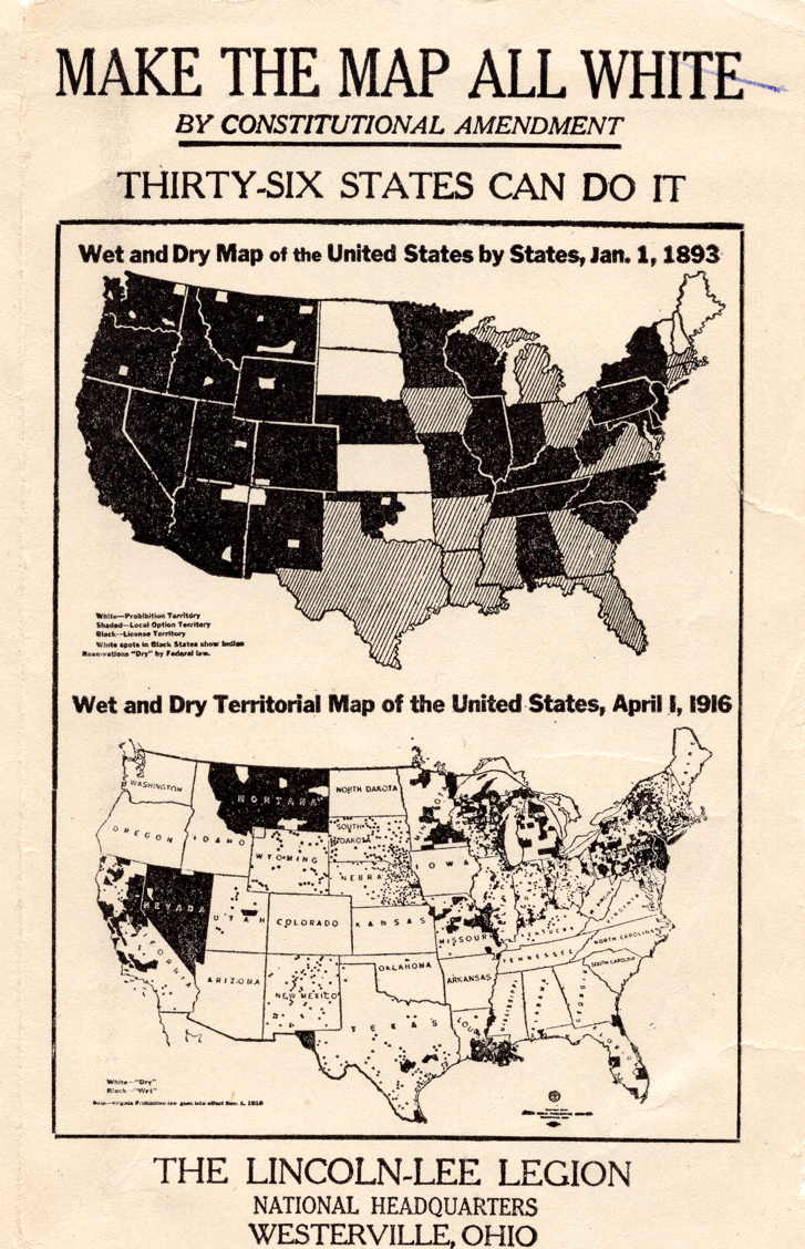
Figure 9: This 1916 pamphlet reflected both the rural strength and the national ambition of prohibition. Originally the “Lincoln Legion,” the group was renamed the “Lincoln-Lee Legion” to honor the cultural identity of many White Southerners. Courtesy of Boston Rare Maps.[132]
The catalyst for federal prohibition came with the declaration of war against Germany in April 1917, which the ASL used to transform the dry crusade into a matter of national defense. A call to preserve grain in order to feed American allies was only one of ways that the amendment gained legitimacy so soon after being defeated in 1914.[133] Just as potent was the ASL’s conflation of the brewing industry with Germany. But even more consequential was the way the war aggregated emergency powers to the federal government. Prohibition was to some extent swept up in this domestic mobilization, a process that included an unprecedented campaign of public information in support of the war, a swift crackdown on dissent and disloyalty, and a redirection of the national economy in service of defense.[134]
Within months of declaring war, the Senate passed the second iteration of the prohibition amendment, known as the Sheppard-Hobson Bill.[135] The bill swiftly passed the House as well, aided by the rapid spread of vicious anti-German sentiment that made the brewing industry a convenient enemy of the public.[136] To support the amendment—to purge the country of immigrant influence and make it “white”—was to demonstrate one’s patriotism. In the ratification phase, prohibitionists continued to press their case with maps, even advertising their cause in suffrage journals.[137] A year later, the Eighteenth Amendment was ratified, representing one of the most ambitious federal efforts to control individual behavior in American history. The map had been made “all white.”
III. Suffrage
The woman suffrage movement owes its origins to antebellum reformers.[138] In examining the injustice of slavery, for instance, many abolitionists began to reconsider the position of women.[139] When the 1840 World Anti-Slavery Convention in London ruled that only male delegates would be seated, Lucretia Mott and Elizabeth Cady Stanton began to see the limits placed on their sex even within their community of reformers.[140] Mott was also influenced by visits to the Seneca Nation, where she saw indigenous women exercising rights in a way that highlighted the gender inequalities of her own society.[141] Recognizing the need for “protest and discussion,” Mott and Stanton organized the Seneca Falls “Women’s Rights Convention” in 1848.[142] That meeting of several hundred women produced a document that demanded voting rights as human rights.[143]
The destruction of slavery in the Civil War offered tremendous hope to suffragists who linked their own cause with that of the freedmen.[144] Frederick Douglass was a crucial ally to these early suffragists,[145] though he and other abolitionists argued that enfranchisement of the freedmen was far more urgent.[146] White abolitionist Wendell Phillips argued that any effort to join the two struggles would endanger the freedmen, insisting at the end of the war that “this hour belongs exclusively to the negro.”[147]
The subsequent passage of the Fourteenth and Fifteenth Amendments became a serious point of contention within the women’s rights movement. Together, these two amendments complicated the status of women’s rights by explicitly attaching citizenship to sex, thereby separating women even further from the ballot box.[148] Stanton was appalled that Black men won the franchise before women,[149] and she joined with Anthony to form the National Woman Suffrage Association (NWSA) in 1869 to pursue a federal amendment to that end.[150] By contrast, the American Woman Suffrage Association (AWSA) turned its energies to state-level efforts to secure women’s voting rights.[151] For both organizations, however, the marginalization of women brought by the Fifteenth Amendment crystallized the importance of suffrage.[152]
In 1875, the Supreme Court dealt another major blow to women’s suffrage. Virginia Minor attempted to register to vote in Missouri and—upon refusal—claimed that her Fourteenth Amendment rights of citizenship and voting had been violated. The Court found that though Minor may be a citizen, she did not necessarily have the right to vote. Instead, the Amendment only protected those rights which had already been granted at the state level.[153] Within a few years of the decision, U.S. Senator Aaron Sargent of California introduced a constitutional amendment granting women the right to vote, which many suffragists hoped would become the Sixteenth Amendment.[154] But, like prohibition, the earliest progress in suffrage came not at the national but at the state level. In this case, it was in the sparsely settled states of the interior West where suffrage first succeeded.
In the late nineteenth century, Wyoming, Utah, Colorado, and Idaho gave women complete access to voting rights. Yet we would be wrong to assume these decisions resulted from enlightened notions of gender equality.[155] The Utah Territory initially granted voting rights to women as a bulwark against anti-Mormon measures;[156] in Colorado, voting rights were granted to women through an alliance of populists, temperance activists, journalists, and other reformers, boosted further by the campaign to freely coin silver.[157] In other words, these early instances of full enfranchisement were primarily transactional, granted to advance other causes in a region of unsettled politics and strong reform movements.[158]
Unified behind the drive to win voting rights at the state level, the NWSA and AWSA merged in 1890 to form the National American Woman Suffrage Association (NAWSA).[159] Yet after Idaho in 1896,[160] not a single state extended full voting rights to women until 1910.[161] In that period, six statewide initiatives to enfranchise women were introduced—all in the West—and all six were defeated, echoing the limited gains of the prohibition movement at the same time.[162] In fact, among the earliest advocates for women’s suffrage were temperance activists who believed that women—armed with the vote—would advance the regulation of alcohol.[163] Temperance organizations such as the Prohibition Party, the WCTU, and the ASL were among the first to formally endorse votes for women.[164] Women’s suffrage was assumed by both supporters and opponents to mean votes for prohibition and, more generally, the purification of politics in an era of growing concern over corrupt urban political machines.[165]
But this tight association between prohibition and suffrage also prompted concern and even backlash. In 1896, Anthony asked Willard not to hold the WCTU convention as planned in California for fear that it would deter support for the state referendum on woman suffrage.[166] As predicted, the liquor industry fought hard against the California referendum, leading to a stinging defeat for suffrage in that state.[167] After Willard’s death in 1898, leading suffragist Carrie Chapman Catt even asked the WCTU to refrain from publicly associating with the NAWSA for fear of alienating men who might be sympathetic to suffrage but skeptical about prohibition.[168] And, in fact, the suffrage movement endured several defeats from 1893 to 1910, making the likelihood of an “Anthony Amendment” seem even more remote at the turn of the century. Woman’s suffrage was indeed in “the doldrums.”[169]
This interdependence of suffrage and prohibition helps explain how the two movements adopted similar strategies to measure and advance their cause.[170] It was at this moment of comparative weakness that suffragist Bertha Damaris Knobe mapped not the failures of the movement but its achievements, shown in Figure 1. Writing for Appleton’s Magazine at the end of 1907, she claimed—rather astonishingly—that suffrage sentiment was spreading like wildfire, though women enjoyed full voting rights in only four sparsely settled interior western states.[171] Not a single state enfranchised women between 1893 and 1910, yet Knobe was quick to identify “close calls” in California, South Dakota, and elsewhere. She also pointed to support for suffrage among labor and populist groups, sympathetic editorials from the nation’s newspapers and magazines, and the growth of voting rights across Europe.[172]
Perhaps most important was Knobe’s decision to pay attention to partial suffrage, which Anthony considered a “hindrance rather than a help toward securing full enfranchisement.”[173] Many states gave women the right to vote in elections governing schools, taxes, and alcohol long before full voting rights had been achieved. Anthony’s dim view of these partial voting rights was reflected in her official, and widely used, history of the suffrage movement, which frequently excluded information on arenas such as school elections.[174] In light of this, Knobe’s map takes on greater significance, for she broadened the definition of voting rights in order to reframe the progress of suffrage. To visualize this progress, she mapped not just the four states with full enfranchisement but also those allowing women to vote in elections governing schools, taxes, and alcohol.
Knobe’s decision to highlight these partial voting rights reflected a new strategy of the larger movement: rather than insist on equality in all areas, as Stanton had, many suffragists at the turn of the century embraced more limited and achievable gains that respected regional customs and gender roles.[175] Just as Frances Willard had encouraged southern and eastern temperance activists to support woman suffrage as a form of “home protection,”[176] suffragists often presented the vote as a way for mothers to fulfill their maternal responsibilities.[177] Knobe mapped this strategy by identifying any progress of woman’s suffrage, such as the right to vote in school elections or presidential primaries. Moreover, while the History of Woman Suffrage stressed that school suffrage was largely limited to the West,[178] Knobe took care to identify and map these rights. Seen in this light, her map is as much an act of aspiration as of reporting, an effort to boost the movement by marking minor victories that many suffragists considered inconsequential or even detrimental.[179]
Within a few weeks of its appearance in Appleton’s Magazine, Knobe’s map had been reproduced in suffrage publications and a lively conversation about its origin developed in the pages of the Woman’s Journal.[180] Iva Wooden claimed that the idea of mapping suffrage belonged to Anna Nicholes and Sophonsiba Breckenridge, who had designed a map to promote Chicago’s municipal suffrage campaign in 1907.[181] Knobe acknowledged that she had seen that map in Chicago and that it had inspired her to create others.[182]
But more relevant here is Knobe’s comment that the practice of shading to measure distribution of any given phenomenon—be it “prohibition or the corn crop”—had long been established.[183] This observation indicates that she had been exposed to the many prohibition maps that circulated at the turn of the century. More fundamentally, it underscores the degree to which maps had become common tools of measurement, assessment, and analysis as well as political persuasion and advocacy. In other words, Knobe suggested that to claim credit for the “suffrage map” would be to ignore that thematic maps had become routine modes of communication.[184]
Knobe went on to highlight the proliferation of suffrage maps within the movement, and then advised readers to maintain the accuracy of the maps in light of the avalanche of recent gains for women in the realm of school elections.[185] Keeping the maps current, she noted, was no small feat, but that was of course the entire purpose of the design.[186] She closed not by insisting on the originality of her map but instead by encouraging others to make their own, “for it is a most effective way to advertise the cause.”[187] The Woman’s Journal followed up by promoting large, outline-style wall maps for purchase that suffragists could annotate to show the advancement of voting laws across the country.[188] Just as Mary Hunt encouraged WCTU members to map local gains in temperance education, Knobe encouraged women to map the progress of suffrage rights. Through these efforts, both movements attached the efforts of local women to the national cause.
Bertha Knobe created her map of suffrage—shown in Figure 1—in late 1907, just as Mabel Dufford was preparing a strikingly similar map of prohibition for the WCTU.[189] But while Dufford identified prohibition victories in white, Knobe darkened women’s suffrage states in black and used medium shading to identify states that gave women partial or limited voting rights. The simultaneous creation of these maps also underscores the way that both movements were embracing a more visual and persuasive strategy. Knobe invoked the suffrage map as a way to “advertise the cause,”[190] while the prohibitionists hailed Dufford’s map as “an effective lesson.”[191] In this respect, the suffragists were taking cues from the emerging world of consumerism and commercial advertising, making use of public spaces such as billboards, newspapers, pamphlets, streetcars, and even sandwich boards.[192] In the same way that Ernest Cherrington sought to let prohibition play out in the press, the suffragists sought to keep the vote newsworthy in order to make it familiar. To this end, they also planned mass meetings, parades, pageants, suffrage-themed entertainment, and May Day celebrations, all in the hope of attracting media attention.[193] Maps were essential to this new visual phase of the suffrage movement.[194]
This strategy of advertising and public spectacle was on full display in California’s massive—and successful—suffrage campaign in the spring of 1911. With lively parades, massive rallies, enormous billboards, electric signs, and organized picnics, the campaign flooded public spaces, aided by thorough mailing campaigns that distributed over three million pieces of literature and ninety thousand buttons in southern California alone.[195] As California suffragist Alice Park urged her contemporaries, the movement must “embrace spectacle.”[196] Victory in California—preceded by Washington in 1910 and followed by other western states—gave the movement a powerful reason to update the map and further champion this visual tool. In other words, the achievements of the movement fed the relevance of the map as a chronicle of ongoing legal change. In turn, the suffrage map, constantly updated and reissued, became a source of news itself, a way to reflect and exercise that progress in service to the campaign.
As Christina Dando has noted, by 1911 suffragists had reversed the color scheme so that white represented states with full voting rights, black represented those without, and shading indicated partial suffrage.[197] As shown in Figure 10, this visual shift aligned the suffrage map with that of prohibition and echoed the powerful anti-slavery maps of the 1850s where a virtuous white geography confronted a dark spatial threat.[198] This reversal also aligned the map with the larger arguments that the vote emancipated women, bringing them from darkness (black) into light (white).[199] At the same time, suffragists began to use the prohibition slogan—“Make the Map All White”—for their own ends.[200]
Dando stresses that the suffrage movement’s association with white not only evoked purity, virtue, and enlightenment but also race.[201] And, to be sure, prohibitionists and suffragists both adopted the slogan at a moment when southern Whites were systematically segregating, disfranchising, and terrorizing Blacks.[202] In this context, the racial overtones of this use of the term “white” in the movement could not have gone unnoticed. The map and slogan were used together in countless public venues throughout the 1910s, a tidy message that leveraged full voting rights in the West and partial voting rights across the nation in service of the ambitious agenda of full enfranchisement nationwide.
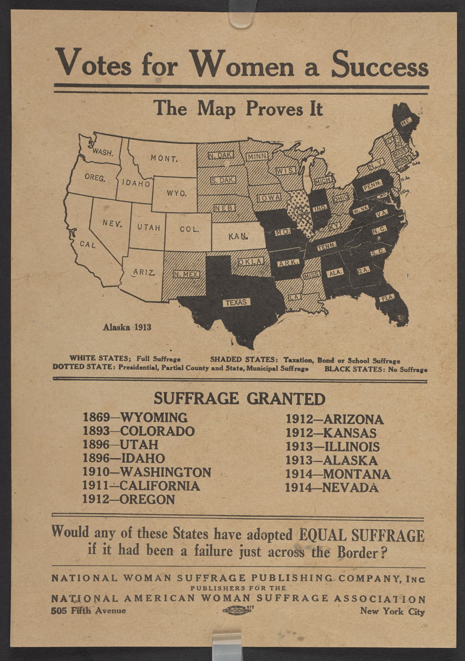
Figure 10: The NAWSA relied on maps to leverage the progress of suffrage in the West. Its bold, visual campaign mirrored the contemporary emergence of similar techniques in advertising. Courtesy of the British Library Board.[203]
Some suffragists went beyond catchphrases to actively court southern White support by invoking racial tropes and threats. The racial hierarchy of the suffrage movement has long been established.[204] Many suffragists, from Elizabeth Cady Stanton forward, held racial views that shaped both the structure and operation of the movement.[205] The celebrated 1913 suffrage march in Washington, D.C. segregated Black women into a separate cohort.[206] The NAWSA was also willing to “sell” suffrage as a bulwark against the Black and immigrant male vote.[207] Catt often tempered her advocacy for racial equality in order to solicit White southern support: she occasionally argued that female suffrage would serve as a bulwark against the Black male vote, and also encouraged those states to require an educational qualification for voting.[208]
Catt’s “pragmatic” deference to southern racial hierarchies under Jim Crow was part of the same strategy that led her to forge meaningful alliances with other national organizations, perhaps most importantly the American Federation of Labor.[209] This transactional spirit, in other words, aided the movement in some instances but at a terrible cost; as the rights of White women voters were expanding—especially in the West—Black men in the South were systematically disfranchised through grandfather and literacy clauses, poll taxes, intimidation, and terror.[210]
How deeply suffrage leaders ignored—or were even complicit in—this disfranchisement is a subject of historical debate, yet both northern and southern suffragists occasionally advocated restrictions on southern voting in order to win White male support, as we will see below. Many suffragists understood that elite White southern men might actually be willing to enfranchise White women as a means to this end.[211] And yet these racial strategies uniformly failed: not a single southern state enfranchised women until Arkansas permitted White women to vote in presidential party primaries in 1917.[212] In fact, after 1910 southern states actively rejected the suffrage amendment (and any woman suffrage) as a threat to state rights, white supremacy, and southern civilization.[213] Accordingly, Catt’s “Winning Plan” of 1916 called for the movement to avoid spending further time and money on southern suffrage initiatives that had little chance of success.[214]
Such racial compromises and transactional reasoning were not limited to suffrage activists. Former president Theodore Roosevelt voiced deep opposition to woman’s suffrage when speaking to the leading anti-suffragist Mary Ella Lyon Swift. As Roosevelt wrote in 1911, “Women do not really need the suffrage although I do not think they would do any harm with it. Their needs are along entirely different lines, and their duties are along entirely different lines.”[215] Within a year, Roosevelt had acrimoniously left the Republican Party to run for president on the new Bull Moose Progressive Party and, in the process, reversed himself to support women’s suffrage “without qualification or equivocation.”[216] He predicted that by 1918 nobody in America would oppose women’s suffrage, an overstatement that nonetheless anticipated the Nineteenth Amendment. Jane Addams responded by throwing her support to Roosevelt.[217]
Yet in that same month, Roosevelt chose to endorse the all-White delegations to the Progressive Party Convention, arguing for the exclusion of southern Blacks on the grounds that they had been overly loyal to the Republican Party, which he now deemed as corrupt.[218] Roosevelt turned his back upon Blacks to curry favor with southern White voters in the 1912 primary, arguing that the election of the “best White men in the South” would do the most to uplift African Americans in the long run.[219]
The WCTU and ASL had long supported woman’s suffrage as well, yet all of these high-profile and organizational endorsements did little to advance the movement; as late as 1914, all state victories for full women’s suffrage remained west of the Mississippi River. Suffragists began to leverage this geographical weakness into a strength by prominently representing the full-suffrage states of the West as a solid bloc in white on their persuasive maps. Suffragists enthused that these western victories were a harbinger of national progress, for each state that had converted to suffrage bordered on one that had already moved in that direction. As one broadside rhetorically asked, “Would any of these [western] states have adopted EQUAL SUFFRAGE if it had been a failure just across the Border?”[220] In the same vein, Colorado suffragist Minnie Reynolds designed a handbill for NAWSA in 1913 arguing that western states had taken cues from their neighbors and therefore that the map “proves the success” of woman’s suffrage.[221] Another broadside reproduced the map alongside a boast that “Imitation is the sincerest flattery.”[222] Annual conventions of the NAWSA in 1911, 1912, and 1913 all reported heavy demand for these suffrage maps and proposed several ways to use them.[223]
Despite these undeniable gains in the West, Alice Paul grew impatient with the NAWSA’s incremental approach and the slow progress of the movement.[224] Many initiatives in eastern states had failed, and president-elect Woodrow Wilson made clear that this was a matter for the states rather than Congress.[225] Inspired by the British suffragettes who used direct action to advance more ambitious goals, Paul founded the Congressional Union for Woman Suffrage (CUWS) in 1913 to reintroduce a federal constitutional amendment to enfranchise women.[226] On the eve of Wilson’s inauguration in March 1913, she led a march in Washington, D.C. to press for congressional action on such an amendment.[227] This demand for a federal amendment enfranchising women is captured in Figure 11. This timing was remarkable: just when Wayne Wheeler and the ASL insisted that federal action be taken on the prohibition question, Paul demanded that federal action be taken on behalf of women’s suffrage.
The suffrage march on Washington in March 1913 drew enormous attention, a national spectacle that resembled the lively state campaigns such as that in California in 1911. A few weeks after the march, The New York Times prominently featured the updated suffrage map in its Sunday edition to illustrate “the banner year for the cause” that converted so many western states.[228] In response, one irritated Massachusetts reader wrote to the Times to challenge not just the wisdom of extending voting rights to women, but the suffrage map itself. As he wrote, only the “crude, raw, half-formed” states of the “weird and wooly West” enacted suffrage.[229] Most importantly, the vast majority of Americans lived in states that either refrained from passing these initiatives or rejected them.[230] In his mind, the suffrage map was a willful misrepresentation.[231]
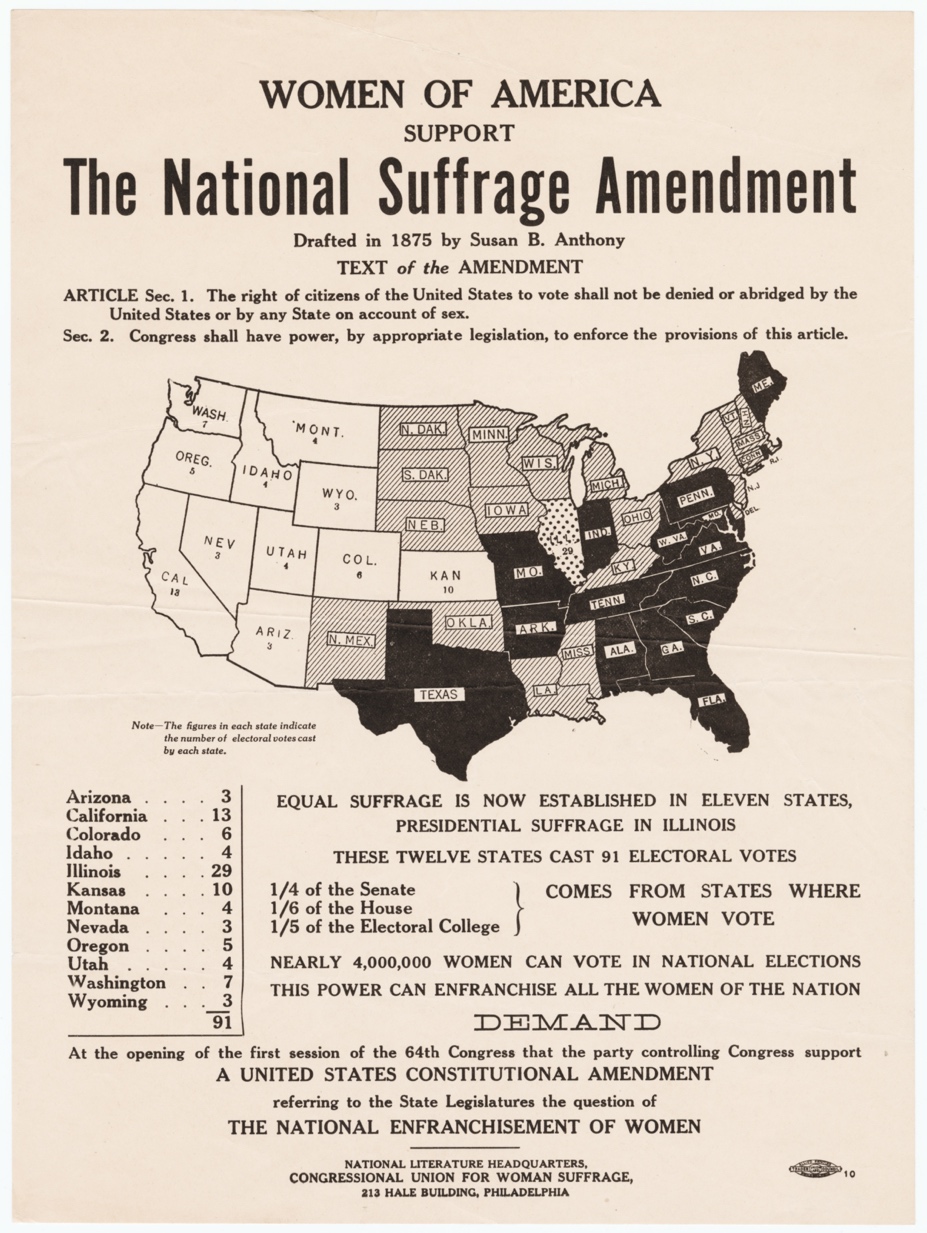
Figure 11: The reintroduction of the “Anthony Amendment” by Alice Paul made the “suffrage map” even more useful. This broadside argues that support for voting rights was growing and that the enlarged constituency of voting women could extend those rights further. Courtesy of Cornell University—PJ Mode Collection of Persuasive Cartography.[232]
Along the same lines, the anti-suffrage journal The Woman’s Protest challenged these suffrage maps by pointing out that the true extent of suffrage support would not be indicated by geographical area but rather population density.[233] As the writer pointed out, imminent suffrage initiatives in New Jersey, Massachusetts, New York, and Pennsylvania—four of the most populated states in the Union—would be the true test of whether “the scheme which has floated into effect in small Western States on waves of Populism, Mormonism, Socialism and so-called Progressivism shall be added to the already over-complex machinery of government.”[234] The suffragists continuously issued maps, the writer argued, that misled people to assume that it was area, rather than people, who voted.[235] And, in fact, each of those four initiatives in heavily populated states failed.
The ubiquity of the suffrage map prompted the National Association Opposed to Woman Suffrage to issue a graphic of its own, as shown in Figure 12. Here, anti-suffragists visually argued that the true measure of support was not area but population. The miniscule suffrage states represented by men dressed in white were vastly outnumbered (and outsized) by black-clad figures representing states that defeated or ignored suffrage, chiefly New York. The accompanying explanation chided suffragists for exaggerating the momentum behind their movement: “The entire population of those eleven suffrage states is about 900,000 less than the population of the state of New York . . . [and] there are fewer inhabitants in the state of Nevada than in the city of Lawrence, Mass.”[236]
Perhaps most revealing aspect of the image is the description of women’s votes as “double suffrage,” suggesting a redundant and pointless replication of the male vote. Such language reminds us that opponents of suffrage did not deny the need for female representation but believed this came through their husbands, brothers, sons, and fathers. That the anti-suffragists responded to the suffrage map with a graphic of their own also reveals how much the campaign had taken on a visual character, with each camp advertising its arguments. One anti-suffrage journal enthusiastically reprinted this graphic for its readers alongside a detailed critique of the way suffragists had used maps to exaggerate support for their cause.[237] The message was clear: the suffrage map was a lie.[238] Like prohibition maps, the suffrage maps had become so common that they could not be ignored.
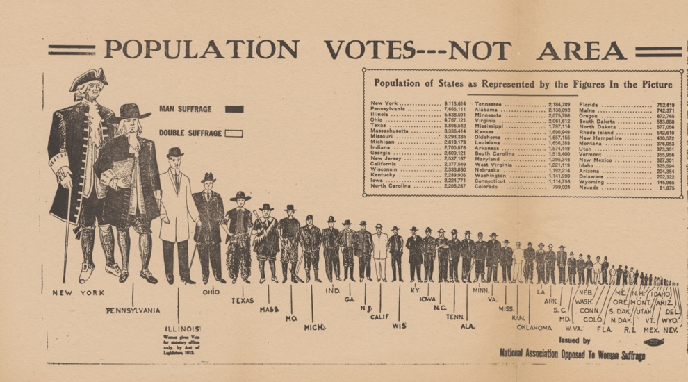
Figure 12: The ubiquity of the “suffrage map” prompted anti-suffragists to design visuals deriding the women’s vote as a redundancy, mere “double suffrage.” Note especially the concern that suffragists had used maps to exaggerate the extent of support for voting rights. Courtesy of Cornell University—PJ Mode Collection of Persuasive Cartography.[239]
Other objections to the suffrage map took direct aim at the long-assumed connection between women’s suffrage and temperance. The Remonstrance actually used the familiar prohibition map to demonstrate that the extension of full suffrage rights in the American West brought no corresponding temperance laws.[240] The anti-suffrage Woman’s Protest similarly reproduced Dufford’s prohibition map to show that suffrage initiatives had not advanced temperance anywhere in the country.[241] As the author wrote, suffragists had sold the vote to some skeptics by promising that temperance would follow, but Dufford’s map demonstrated that “[n]ot one of the states that has prohibition is a Suffrage State.”[242]
These anti-suffrage outlets relentlessly emphasized that voting rights for women had been confined to the West. In her 1911 presidential address to the NAWSA, Catt turned that weakness into a strength. The earliest states to award women voting rights were indeed those that she remembered learning about in school as the desolate states of the “Great American Desert.”[243] But, she argued, “[t]he newest developments come from new lands, where traditions and long-established customs have least influence.”[244] Echoing the map, Catt wrote that it was the West that would civilize the East when it came to voting rights.[245]
As the suffrage movement renewed its attention to a federal amendment, it borrowed some of the strategies of prohibition. In 1913, the Anti-Saloon League began to leverage southern and rural support for temperance for a federal prohibition amendment. At the same time, suffragists similarly leveraged the momentum in the West by arguing that it was indicative of a larger trend. In Figure 11, for example, the CUWS framed the constitutional amendment as an inevitable outgrowth of growing support that was concentrated in the West but actually extended across the country if partial suffrage victories were considered. As the CUWS stated in 1915, the suffrage map “tells a story all its own . . . . And now the national story is beginning . . . it is time to pass a national amendment and make the whole map clear.”[246] The CUWS also mapped the number of representatives and electoral votes in each of the western states in order to train its members to think in terms of congressional representation and the Electoral College.[247]
But in pressing the constitutional amendment, the CUWS sent contradictory messages. Figure 11 celebrates the fact that nearly four million women can now vote in national elections, and that “this power can enfranchise all the women of the nation” if we “DEMAND” a constitutional amendment. Here, the rhetoric was broad and inclusive, asserting rights for all women. Yet the CUWS also took care to address fears that the enfranchisement of women would challenge existing power structures, particularly in the South.
In a broadside published in Philadelphia, the CUWS insisted that a federal suffrage amendment would “IN NO WAY complicate the race problem.”[248] Using recent census data, the broadside calculated that in all southern states save for Mississippi and South Carolina, “THE WHITE WOMEN GREATLY OUTNUMBER THE NEGRO WOMEN,” and in nine of those states, “THE WHITE WOMEN OUTNUMBER THE TOTAL NEGRO POPULATION.”[249] In other words, there was no reason “why the presence of negro women should debar women from voting.”[250] Southern poll taxes and educational requirements, the broadside reminded voters, would remain in place even with a federal amendment.[251] The broadside acknowledged that the individual states had “widely-varying voting qualifications—some wise; some unwise.”[252] Women neither made these restrictions, nor did they have the power to change them. “They merely ask that where a woman measures up to the standard required of a man,” she be permitted to vote. The CUWS explicitly reassured voters that a suffrage amendment would not challenge the southern racial hierarchy.
As Alice Paul and the CUWS focused on the federal amendment, the NAWSA turned its attention to campaigning for women’s voting rights in the next great battleground, New York State.[253] Victory in New York would reap enormous rewards given not only its population but also its geography: it would be the first state east of the Mississippi to grant full voting rights to women. The state legislature passed the referendum in January 1915, leaving it to the voters to determine the fate of woman suffrage that November.[254] The national significance of this campaign is captured by a dramatic graphic published in Puck magazine, shown in Figure 13. Puck had long been a staple of political humor and satire, yet in this graphic German immigrant Henry Mayer—the magazine’s chief illustrator—revealed his sympathies with little of the magazine’s trademark irony. A classical embodiment of liberty strides from the pure white bloc of western states toward young women drowning in the blackened East, desperate for salvation. The women seeking—as well as delivering—the vote were all presented as racially White. Moreover, the traditional spatial narrative of progress and civilization marching from east to west had been entirely reversed.
Mayer’s graphic was one of many suffrage maps designed to advertise the Empire State Campaign in 1915, printed on paper fans, drinking glasses, calendars, and baseball programs. The NAWSA actually invested so much in these materials that it became financially impractical to keep the map current, an indication of how essential these images had become to the movement.[255] Opponents similarly acknowledged the power of the map, for one anti-suffragist objected that although “the solid block of suffrage states…stares at us,” it was but a “wave of hysteria well organized and shrewdly conducted as a demand for ‘rights’ (i.e., power) made by a comparatively small group of self-interested men and women.”[256] These skeptics consistently claimed, among other things, that the map “exaggerated” the breadth and depth of support for suffrage.
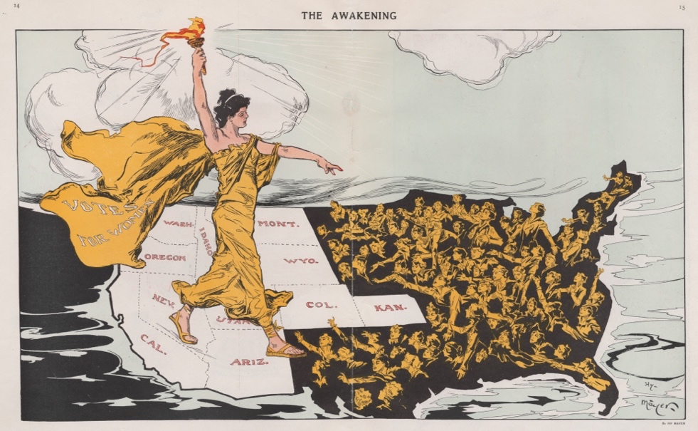
Figure 13: The 1915 “Empire State Campaign” sought—and failed—to extend voting rights to women in New York. German immigrant Henry Mayer sympathetically presented the suffrage movement as a geographical phenomenon rolling from west to east. Courtesy of Cornell University—PJ Mode Collection of Persuasive Cartography.[257]
Despite the investment by the NAWSA, the first Empire State Campaign failed,[258] a reminder of the obstacles posed by established parties and urban populations that associated suffrage with prohibition.[259] Indeed, Mayer’s graphic evokes this by suggesting that eastern women were reaching out from a densely populated maw of resistance. In this respect the suffrage movement converged with prohibition and frequently identified Northeastern cities as controlled by a corrupt alliance of liquor interests and immigrant and ethnic voters. In 1913, for instance, NAWSA president Anna Howard Shaw explained recent suffrage defeats in Ohio and Wisconsin by pointing to the “great German population” and “the beer interests.” As she put it, the “liquor interests…defeated us in both States.”[260]
Similarly, CUWS co-founder Caroline Katzenstein created a map that attributed the defeat of Pennsylvania’s suffrage referendum in 1915 to ethnic and urban voters. As shown in Figure 14, Katzenstein darkly shaded counties where a majority defeated suffrage and pointed out that almost all of these were concentrated in the “urban” areas around Philadelphia as well as the “semi-German counties” of eastern Pennsylvania.[261] In a state where suffrage failed by a handful of votes, and where it won nearly half the vote “outside of Philadelphia,” the message was clear: the urban, ethnic, and immigrant enclaves remained the greatest obstacle. The Pennsylvania Men’s League for Woman Suffrage printed and distributed thousands of copies of Katzenstein’s map free of charge. In its postmortem report, the Men’s League argued that the referendum to enfranchise women was defeated by the “ignorant and ‘kept’ among the electorate united with the saloon interests.”[262]
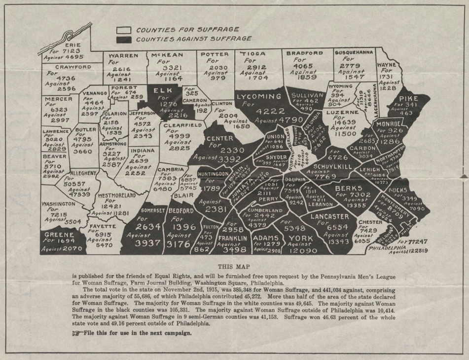
Figure 14: Caroline Katzenstein, co-founder of the CUWS, designed this map after Pennsylvania voters defeated the suffrage initiative of 1915. She noted that the urban and German-dominated counties remained obstacles to suffrage, something that ought to be understood “for use in the next campaign.” Courtesy of the Historical Society of Pennsylvania.[263]
Indeed, the largest and most powerful organization to endorse woman suffrage in 1916 (as in prior years) was the Anti-Saloon League, a recognition of shared purpose.[264] Both the Republican and Democratic parties gestured toward suffrage in their 1916 platforms but made clear that this was a matter to be determined by the individual states.[265] And despite the defeats in New York and Pennsylvania, earlier progress on suffrage meant that four million women were now eligible to vote in the 1916 presidential election.[266] Alice Paul leveraged this base by proposing a new National Woman’s Party (NWP) to advocate for the federal amendment. That summer she toured the West to mobilize these female voters on behalf of the amendment, as shown in Figure 15. This map was featured on the front page of her journal, the Suffragist, to highlight the power of this new female constituency.[267] As the accompanying article observed, the twelve western states that had enfranchised women by 1916 constituted one–quarter of the Electoral College.[268]
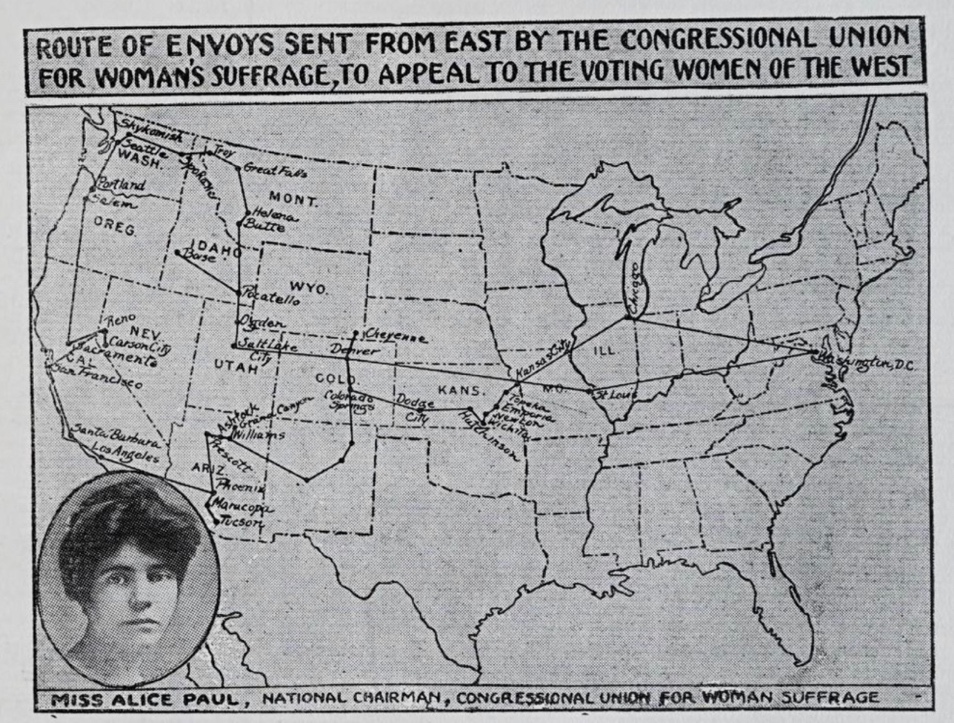
Figure 15: Alice Paul traveled west in the summer of 1916 to mobilize voting women behind the suffrage amendment. Her map reflects the shifting dynamics of political power, where voting women in the West were encouraged to use their newfound legal rights on behalf of women across the nation.[269]
A 1916 Colorado billboard mounted by the NWP underscores that emerging political voice. As Figure 16 illustrates, Democrats had done no more (or less) than Republicans to support the amendment, yet Paul and the NWP held Wilson and the Democrats accountable as the party in power. Wilson, having promised to keep Americans out of the European war, glided to reelection and even carried ten of the twelve states where women were fully enfranchised.[270] Moreover, the NWP effort to defeat congressional Democrats in those states failed.[271] Yet the billboard captured a new regional and gendered constituency, and by extension a fluid political dynamic in the West, even as the rest of the country continued to resist suffrage.[272]
The South and East remained hostile to full woman’s suffrage as late as 1916, but the nation’s entry into World War I accelerated support for both suffrage and prohibition. Ironically, while the war heightened appreciation for women’s contributions to the home front, that same mobilization of the home front sparked a reactionary spirit that aided prohibition. Both movements successfully exploited public sentiment about the war in service to their particular goals. Oddly, suffragists were deeply split about the war itself, with some ardently opposing it and others actively supporting the national mission in order to avoid the appearance of dissent or disloyalty.
Among the anti-war suffragists was Alice Paul and the NWP, who in January 1917 began to silently picket the White House and its occupant—whom they dubbed “Kaiser Wilson”—to press the federal amendment.[273] The response to these peaceful demonstrations created a spectacle, with protestors harassed, arrested, and brutalized in jail.[274] Paul claimed these tactics generated support for the amendment.[275] Catt and others in the NAWSA rejected such direct action, even though her newly adopted “winning plan” implicitly acknowledged Paul’s longstanding insistence that the federal amendment was the best path forward.[276] Yet the NAWSA recognized that the amendment required support from at least one eastern or southern state, and both of those regions remained hostile to suffrage.[277]
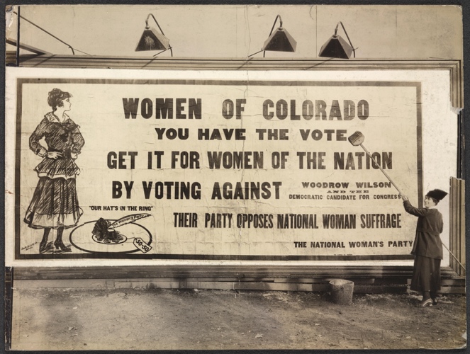
Figure 16: This Colorado billboard from 1916 reflects Alice Paul’s strategy of keeping the party in power accountable to women voters. Though Wilson safely won reelection in 1916, the NWP represented a new phase of direct political pressure in the suffrage movement. Courtesy of the Library of Congress.[278]
That resistance was overcome in 1917. Throughout that year, a series of partial suffrage victories across the High Plains and the Midwest indicated a modest shift in sentiment; North Dakota, Ohio, Indiana, Nebraska, and Michigan gave women the right to vote in presidential elections,[279] then Arkansas permitted women to vote in presidential primaries.[280] That limited momentum created a fundamentally different geography, which suffragists eagerly recorded on their maps.[281] The suffrage map could hardly keep up with these changes, but even dated versions remained in shop windows and other public places as a reminder of this ongoing energy in 1917.[282] In July, the Woman’s Journal rallied its readers to continue the fight for statewide suffrage in order to “Make the map white from Portland to Portland.” This article—like most of its type—did not even reproduce a map, for this visual had become a metaphor for suffrage itself, thoroughly assimilated into the movement’s rhetoric.[283]
Those two developments—NAWSA state-level victories and protests at the White House—were just two forces at work as the U.S. entered the war in the spring of 1917. Catt abandoned her prior pacifism so that the suffrage movement would not be branded as unpatriotic.[284] In doing this, she also distanced herself from the NWP.[285] Yet Paul’s stance against the war as well as her use of direct action might have actually enhanced the appeal of the NAWSA among legislators and Wilson, for it was seen as a less threatening voice for suffrage relative to the NWP.[286] Perhaps as important was the way the war brought women into the public sphere, which made it harder to deny them political representation.[287] The General Federation of Woman’s Clubs echoed that sentiment in their Bulletin, arguing that “It took a war to do it,” but “soon our whole map will be white.”[288]
The turning point came in November when New York State voters passed a measure to fully enfranchise women.[289] The decision of Tammany Hall Democrats to remain neutral rather than oppose suffrage proved vital in this second campaign, allowing the men of New York City to determine the fate of the referendum.[290] In that campaign, Catt strategically aligned the movement with the war effort, even associating the German enemy with the “liquor interest” that had long resisted suffrage.[291] Crucial as well was the New York City Suffrage Party’s immense campaign of persuasion, which distributed over five million leaflets and sponsored films, parades, open air meetings, and other events.[292] Figure 17 is a postcard from that effort, inviting New York to join the vanguard for suffrage in the West. Note that the map partially shades those states that had granted limited voting rights in 1917, suggesting momentum east of the Mississippi River. The measure passed statewide with a decisive fifty-four percent majority—in New York City alone, the measure passed by a margin of one hundred thousand votes.[293] Wilson supported the New York referendum[294] and soon after its success he endorsed the constitutional amendment.[295] The president was a savvy politician who sensed a shift in public sentiment, but he also recognized that suffragists had supported the war effort.
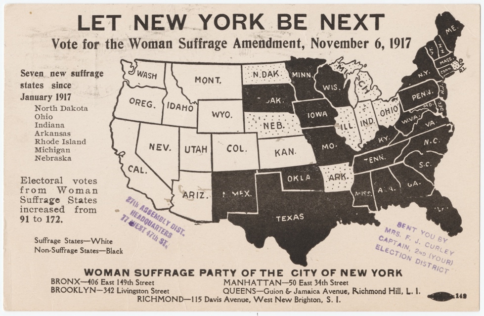
Figure 17: The second Empire State Campaign to enfranchise women in New York succeeded handily in November 1917, an enormous victory for suffrage at the state level but also for the constitutional amendment. Courtesy of Cornell University—PJ Mode Collection of Persuasive Cartography.[296]
That shifting sentiment and dynamic landscape of power is evident in the subsequent House vote on the amendment in January 1918. In 1915 it had garnered only 204 votes, but now passed with exactly the 274 votes needed for a two-thirds majority.[297] Fifty-six of the representatives who changed their vote in those two years from “no” to “yes” hailed from states that had enfranchised women in 1917.[298] Their districts were now accountable to women voters and an electorate that supported suffrage. The Democrats split evenly on the amendment, while the Republicans who courted future voters supported it by a wider margin.[299] Yet passage in the House left the Senate unmoved, and even after President Wilson urged the Senate to support suffrage as a war measure, it failed by two votes.[300] Opponents continued to insist that a federal amendment threatened state rights[301] as well as the war effort.[302] Southerners—still firmly opposed to suffrage—also argued that enfranchising women would threaten the region’s power structure and racial order.[303]
Two months later, South Dakota, Michigan, and Oklahoma expanded voting rights for women.[304] By the end of 1918, the twenty states which allowed women to vote in presidential elections constituted 237 electoral votes.[305] That November, two senators opposed to suffrage were actually defeated, yet the Senate rejected the amendment again in February 1919 by a single vote.[306] On the eve of that vote, the Suffragist used maps to analyze voting patterns of the two chambers, parsing the reasons for the Senate’s resistance.[307] Only on the third vote of June 4 did the Senate pass the amendment, and even then, only with a final vote wrangled from a distance by President Wilson as he participated in the postwar negotiations in Paris.[308]
In the end, it was not lofty arguments about justice and equality that carried suffrage through states or Congress but transactional politics and electoral pressure that included appeals to race, ethnicity, and class. And despite the final passage of the amendment in the Senate, women’s voting rights remained fragile. In 1918, the laws granting women the right to vote in presidential elections had actually been overturned in Ohio (by a referendum), in Indiana (by a court ruling), and in Vermont (by a gubernatorial veto), all of which made a constitutional amendment look less like a luxury than a necessity.[309]
Once the amendment moved to the states for ratification, maps remained fixtures in the NAWSA journal, the Woman Citizen.[310] These “Victory Maps” followed both the continued expansion of voting rights within the states and the progress toward ratification to “make the whole map white.”[311] The first of these is seen in Figure 18, issued in March 1919. The map profiles the state of suffrage rights even before the Senate had passed the amendment. By then the map was thoroughly familiar, but this iteration prominently listed the number of women represented in each state. At lower left, the map celebrated the women who would vote in the next election even without the amendment: “12,500,000. Count ‘em!” At lower right, the many states still represented in solid black indicated the 14.5 million women of all races without a vote in presidential elections. That number, of course, did not acknowledge that even after ratification, Black women in the South would be disfranchised, as had Black men.[312]
This terrible irony was on full display during the ratification process. In the South, few states had granted women access to the ballot, and resistance to the amendment remained strong. That hostility prompted Virginia suffragists to address the fear that enfranchisement of women would disrupt the southern racial hierarchy. In December 1919, the Equal Suffrage League of Virginia issued a broadside insisting that “WOMEN SHOULD BE GIVEN AN EQUAL PLACE WITH MEN IN ALL HUMAN RIGHTS.”[313] At the top was a familiar “Victory Map” from Figure 18, updated to identify the states that had ratified the suffrage amendment. The broadside extolled “The Rights of the People – Women are People” and showcased the many ways that “Virginia women want the vote,” whether as mothers, teachers, church workers, or social workers.[314]
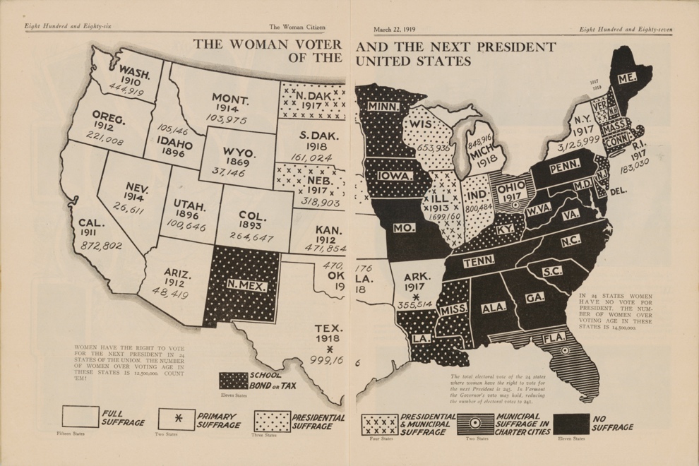
Figure 18: The NAWSA issued this map just as the Senate was considering—for the third and final time—the constitutional amendment to enfranchise women. Each state includes the date that full voting rights had been won and the number of women affected. African American women in the South would remain disenfranchised even after ratification, an argument many suffragists used to reassure White voters to support the amendment. Courtesy of Cornell University—PJ Mode Collection of Persuasive Cartography.[315]
And yet, that same broadside explicitly informed Virginians that the suffrage amendment would pose no threat to the existing political or racial order. An inset shown in Figure 19 insisted that “Women Are Conservative,” and that anti-suffragists need not fear an increase of radical political action if women were enfranchised. More importantly, the broadside proclaimed that the suffrage amendment “DOES NOT remove ANY OTHER QUALIFICATION for voters.”[316] As the League urgently wrote, “WHITE SUPREMACY” would continue and racial restrictions on voting would remain unchallenged.[317] In language and arguments that echoed the CUWS broadside a few years earlier, the League reassured male voters that the proposed Nineteenth Amendment “CANNOT prevent the States from imposing such RESTRICTIONS” that had historically been in place, including poll taxes, residential qualifications, and literacy tests. As the broadside insisted,
There is NOW no negro domination UNDER MALE SUFFRAGE in the counties in Virginia where white people are in the minority, and there will be NO NEGRO DOMINATION with MEN and WOMEN VOTING. The SAME STATE RESTRICTIONS which NOW APPLY to the MAN VOTER will also APPLY TO THE WOMAN VOTER, when the Federal Suffrage Amendment has been ratified.[318]
The insistence on women’s rights as human rights, and the emphasis on equality, alongside an explicit defense of voter disfranchisement indicates how deeply some suffragists had assimilated a hierarchy of race and segregation. The broadside also reflects another legal tension within the suffrage movement. On the one hand, suffragists ultimately decided that their access to the ballot required a federal amendment. On the other hand, many in the movement deferred to a state rights philosophy that actively disenfranchised Black voters across the South. Scarcely a clearer accommodation to Jim Crow could have been written: poll taxes, literacy tests, and other means of disfranchisement—all designed to circumvent the Fifteenth Amendment—would continue under the Nineteenth Amendment.[319] In this respect, the suffrage movement simultaneously broadened and restricted the electorate. Once made all white, the broadside stated, the map would remain all white.
Figure 19: In this portion of a larger broadside, the Equal Suffrage League of Virginia lobbied male voters to support ratification in December 1919. The League reassured voters that women were politically conservative and, even more importantly, that the amendment would not disrupt existing voting restrictions. Virginia did not ratify the amendment until 1952. Courtesy of Boston Rare Maps.[320]
Conclusion
The women’s suffrage movement transformed American democracy by vastly enlarging the electorate and forcing a fundamental recognition of women as political actors. Yet while challenging certain power structures, it benefitted from others. It frequently exploited class, ethnic, and racial divisions and largely advanced the interests of middle-class, White women. Once ratified, the Nineteenth Amendment offered little hope to African American women, who remained disfranchised within a few years through the same tools that had stolen the vote from their male counterparts, including literacy clauses, poll taxes, and violence.[321] The suffrage maps narrate an official tale of universal progress and improvement, yet say little about the millions of women who would be prevented from exercising the vote even with the Nineteenth Amendment. These maps conceal as much as they reveal, for they were created by a very particular group who sought freedoms for some but not for others. In seeking to “make the map all white,” suffragists also exposed their blind spots and limitations.
Similarly, the WCTU and the ASL adopted maps to chronicle even small legal victories for temperance and keep the issue in the news. Pivoting toward the federal amendment in 1913, the Anti-Saloon League widely distributed maps that leveraged regional progress in pursuit of nationwide prohibition. Prohibitionists used maps to advance their reach, recognizing that demographic trends gave them a shrinking window of opportunity to effect nationwide reform in the American electoral system. The resulting Eighteenth Amendment was repealed in 1933, and maps played a role in this process (as did women voters, for that matter).[322] In this respect, the amendment was a failure. But, as Lisa McGirr demonstrates, in other respects prohibition established federal powers of policing and prosecution that remain with us today.[323] The movement envisioned a morally pure and temperate culture, defined by the limited influence of non-Protestants and racial and ethnic minorities. If prohibition activists sought to “make the map all white,” they also sought to control immigrants, the poor, and non-White Americans.[324]
The coincidence of the suffrage, temperance, and lynching maps also reveals something about the character of the progressive reform. Though historians have rightly challenged the existence of a unified “progressive movement,”[325] these maps show that temperance, suffrage, and anti-lynching activists all sought federal action on behalf of their constituencies. Anti-lynching campaigns continued but failed to override the obstacles of state rights that protected the racial hierarchies of the South. And though temperance and suffrage activists had more success—achieving federal amendments—the maps of their movements also remind us that neither of these outcomes were inevitable. In 1900, prohibitionists were understood to be provincial scolds confined to rural outposts in a country that was hurtling toward a more cosmopolitan and urbane future. Yet the temperance movement established its foothold in southern and rural areas before making gains elsewhere. The pivot toward the amendment in 1913 was an act of both confidence and the recognition that demographic trends—and the corresponding reconfigurations of power—would soon make national prohibition unlikely. In a similar way, the right of women to vote was anything but a foregone conclusion, and each suffrage map reveals the extraordinary barriers that remained based not just upon geography but class and race. The maps also remind us of the regional dynamics at play, where statewide gains in the sparsely populated West were leveraged to extract rights for women elsewhere. Seen together, and over time, the maps of suffrage and prohibition capture—but also obscure—the shifting landscape of law and power across the United States.
*Professor of History, University of Denver. I am indebted to Matthew Stewart, Quentin Morse, and all the editors of the University of Colorado Law Review for their guidance. I also thank Michael Buehler, P.J. Mode, Libby Bischof, and Matthew Edney for their feedback, and Christina Dando for her important work on the suffrage maps.
- Bertha Damaris Knobe, The Suffragists’ Uprising, 10 Appleton’s Mag. 772 (1907). ↑
- Eleanor Flexner & Ellen Fitzpatrick, Century of Struggle: The Woman’s Rights Movement in the United States 241 (Belknap Press of Harvard Univ. Press, enlarged ed. 1996) (1959). ↑
- Knobe, supra note 1, at 777. ↑
- See infra Part III. ↑
- Knobe, supra note 1, at 777; Christina Elizabeth Dando, “The Map Proves It”: Map Use by the American Woman Suffrage Movement, 45 Cartographica 221 (2010). ↑
- Bertha Damaris Knobe, Map of the United States Showing Status of Woman’s Suffrage Legislation (map), in Knobe, supra note 1. ↑
- See infra Part II. ↑
- Leona Mabel Dufford, Prohibition Map of the United States (map), in Union Signal (Ill.), Nov. 19, 1908, at 1. Map also reproduced in Nat’l Woman’s Christian Temperance Union, Report of the Thirty-Fifth Annual Convention of the National Woman’s Christian Temperance Union 42 (Recording Secretaries eds., 1909) [hereinafter Report of the Thirty-Fifth Annual Convention]. ↑
- Dufford, supra note 8. ↑
- See infra Parts II and III. ↑
- See infra Parts II and III. ↑
- See infra notes 77–83 and accompanying discussion. ↑
- Flexner & Fitzpatrick, supra note 2, at 174–78. ↑
- See infra Parts II and III. ↑
- Susan Schulten, Introduction to Mapping the Nation: History and Cartography in Nineteenth-Century America 1 (2012). ↑
- Id. ↑
- Id. at 11–40. ↑
- Id. ↑
- Id. ↑
- Joel H. Silbey, Storm over Texas: The Annexation Controversy and the Road to Civil War 6–27 (2005). ↑
- Julius Ruben Ames, Liberty (map), in American Anti-Slavery Society 66 (1837). On the verso of later reprints was another image by Ames, a global perspective on the threat that slavery posed to the world. See Julius Ruben Ames, My Country Is the World (map), in American Anti-Slavery Society, The Legion of Liberty and Force of Truth (1857) (on file at Cornell Univ., PJ Mode Collection of Persuasive Maps, Item No. 1053). ↑
- In 1846, Democratic Congressman David Wilmot of Pennsylvania proposed that any land gained from Mexico be closed to slavery. Reactions divided almost entirely along geographic, rather than partisan, lines. Silbey, supra note 20, at 122–45. ↑
- By 1847, the tract was in its tenth edition and continued to be printed until 1857. Thereafter, it was issued by the American Anti-Slavery Society. Id. ↑
- An Act to Organize the Territories of Nebraska and Kansas, ch. 59, 3310 Stat. 277 (1854). ↑
- Id. at § 14. ↑
- Julius Ruben Ames, Moral Map of the U.S. (map), in American Anti-Slavery Society supra note 21 (on file at Cornell Univ., PJ Mode Collection of Persuasive Maps, Item No. 2051.01). ↑
- Nebraska Territory! Defence of the Missouri Compromise. Protest Against Its Violation. Great Meeting at the Tabernacle. Citizens of New-York in Council, N.Y. Daily Times, Jan. 31, 1854, at 1. ↑
- Id. ↑
- Id. See Susan Schulten, The Cartography of Slavery and the Authority of Statistics, 56 Civ. War Hist. 5 (2010), for a discussion on the mapping of slavery in the mid-nineteenth century. ↑
- Colton, supra note 32. For reproductions of the map, see N.H. Statesman, Apr. 1, 1854, at Column C; State Gazette (N.J.), Mar. 28, 1854. ↑
- See Eric Foner, Free Soil, Free Labor, Free Men: The Ideology of the Republican Party Before the Civil War (1970). ↑
- George Colton, Map of the States in Their Relation to Slavery (map), in The Independent (N.Y.), Mar. 16, 1854, at 88. ↑
- Broadsides are posters or announcements that were designed to be posted in public, and, therefore, printed on just one side of paper. ↑
- Schulten, supra note 29. ↑
- Susan Schulten, The Civil War and the Origins of the Colorado Territory, 44 W. Hist. Q. 21 (2013). ↑
- Eric Foner, Reconstruction: America’s Unfinished Revolution 1863–1877, at 251–61, 445–48 (1988). The Radical Republicans distinguished themselves from their moderate counterparts by advocating voting rights for the freedmen and more punitive measures against the former rebel states. ↑
- U.S. Const. amend. XIV, § 2. ↑
- U.S. Const. amend. XV, § 1. ↑
- Barbara Holden-Smith, Lynching, Federalism, and the Intersection of Race and Gender in the Progressive Era, 8 Yale J.L. & Feminism 31, 36–37 (1996). ↑
- Id. at 37. ↑
- See Ida B. Wells, Southern Horrors: Lynch Law in All its Phases (1892); Ida B. Wells, A Red Record: Tabulated Statistics and Alleged Causes of Lynchings in the United States (1895). ↑
- Ida Wells-Barnett, Lynching Our National Crime, in Proceedings of the National Negro Conference 1909, at 174, 174 (1909). ↑
- Id. at 177–78. ↑
- Id. at 178–79. ↑
- See Patricia Bernstein, The First Waco Horror: The Lynching of Jesse Washington and the Rise of the NAACP (1906). ↑
- Thirty Years of Lynching in the United States 1889–1928 (map), in Nat’l Ass’n for the Advancement of Colored People, Thirty Years of Lynching in the United States 1889–1918 (1919), preceding Table of Contents. ↑
- Scholars have noted the flaws in the NAACP study, largely errors relating to location of these crimes. See W. Fitzhugh Brundage, Lynching in the New South: Georgia and Virginia, 1880–1930, at 292–94 (1993). ↑
- Robert L. Zangrando, The NAACP Crusade Against Lynching, 1909–1950, at 41 (1980). ↑
- Protect Citizens Against Lynching: Hearing on H.R. 11279 Before the Committee on the Judiciary, 65th Cong. 3 (1918). ↑
- Oswald Garrison Villard, Excerpt from Diary (Aug. 14, 1912), in 25 The Papers of Woodrow Wilson 24, 24–26 (Arthur S. Link ed., 1978). ↑
- Thirty Years of Lynching in the United States 1889–1928, supra note 46. ↑
- For subsequent maps of lynching, see Lynching Map, 1919, in 19 Crisis 163, 184 (1920); Madeline G. Allison, A Lynching Map of the United States (map), in 23 Crisis 145, 168–69 (1922); Monroe Work and the American Map Company, Lynchings by States and Counties in the United States, 1900 to 1931 (map), in George Fort Milton, Lynchings and What They Mean: General Findings of the Southern Commission on the Study of Lynching, printed inside book wrapper (1931). ↑
- Julie Holcomb, Antebellum Reform, in The Oxford Encyclopedia of American Social History 46, 49 (2012). ↑
- Id. ↑
- Daniel Walker Howe, What Hath God Wrought: The Transformation of America, 1815–1848, at 167–68 (2007). Most of these “Maine Laws” passed in the 1850s were repealed by the Civil War. Sean Beienburg, Prohibition, the Constitution, and States’ Rights 15–16 (2019). ↑
- See Lisa McGirr, The War on Alcohol (2015); Daniel Okrent, Last Call: The Rise and Fall of Prohibition (2010) (discussing twentieth-century prohibition). ↑
- Robert Graham, Liquordom in New York City 1–10 (1883). The best known of these Gilded Age portraits of urban vice is Englishman William Stead’s 1894 searing account of Chicago, which opened with a stark map of the saloons and brothels in the city’s first ward. W.T. Stead, If Christ Came to Chicago! A Plea for the Union of All Who Love in the Service of All Who Suffer (1894). ↑
- William Henry Blair, Saloon Map of New York City (map), in William Henry Blair, The Temperance Movement: Or, the Conflict Between Man & Alcohol (1888), following the Dedication. ↑
- Blair, supra note 58, at 363. On this genre of “sanitary maps,” see Laura Vaughan, Mapping Society: The Spatial Dimensions of Social Cartography 168–204 (2018). ↑
- Gray was the president of Little Rock University. Union Signal (Ill.), Feb. 1884, at 9. Thanks to Janet Olson, from the WCTU Archives, for this reference. ↑
- Id. ↑
- Ruth Clifford Engs, The Progressive Era’s Health Reform Movement: A Historical Dictionary 160–63 (2003); Jonathan Zimmerman, Distilling Democracy: Alcohol Education in America’s Public Schools, 1880–1925, at 20–21 (1999). ↑
- Okrent, supra note 56, at 20–23 (noting the notoriously dubious information in these textbooks). ↑
- Zimmerman, supra note 62, at 7; Okrent, supra note 56, at 20. ↑
- Temperance Education Map of the United States and Territories (map), in Mary H. Hunt, A History of the First Decade of the Department of Scientific Temperance Instruction in Schools and Colleges of the Woman’s Christian Temperance Union (3d ed. 1892), preceding the Title Page [hereinafter Temperance Education Map]. ↑
- Mary H. Hunt et al., The Pathfinder, or National Plans for Securing Scientific Temperance Education in Schools and Colleges 16 (1885); Temperance Education Map, supra note 65. ↑
- Temperance Education Map, supra note 65. ↑
- Hunt’s critics are treated in Zimmerman, supra note 62, at 15–58. ↑
- Id. at 111. ↑
- Id. ↑
- See Temperance Education Map, supra note 65; Engs, supra note 62, at 161. ↑
- Temperance Instructions, 12 True Republic 274 (1902). ↑
- Woman’s Christian Temperance Union Me., Thirty-Second Annual Report of the Woman’s Christian Temperance Union of Maine 59 (1906). ↑
- Nat’l Woman’s Christian Temperance Union, Report of the National Woman’s Christian Temperance Union Twenty-Ninth Annual meeting 238–39 (1902). ↑
- A Day With the World’s W.C.T.U., 35 Friend 425, 426 (1895); for early examples of WCTU organizing with maps, see Woman’s Christian Temperance Union Mo., Proceedings of the Fourth Annual Convention of the Woman’s Christian Temperance Union of Mo. 26–27 (1886); What Could be Done by a Local Option Law, Christian Statesman, Nov. 26, 1892, at 4. ↑
- See Frances E. Willard, Home Protection Manual: Containing an Argument for the Temperance Ballot for Woman (1879). ↑
- Nat’l Woman’s Christian Temperance Union, Minutes of the National Woman’s Christian Temperance Union at the Ninth Annual Meeting 33 (1882). ↑
- See, e.g., Carli Crozier Schiffner, Continuing to “Do Everything” in Oregon: The Woman’s Christian Temperance Union, 1900-1945 and Beyond (Aug. 2004) (Ph.D. dissertation, Washington State University) (ProQuest). ↑
- See Willard, supra note 76. ↑
- Report of the Thirty-Fifth Annual Convention, supra note 8, at 391. ↑
- See Willard, supra note 76. ↑
- Nat’l Woman’s Christian Temperance Union, Report of the National Woman’s Christian Temperance Union Thirty-Sixth Annual Convention 363 (1909). ↑
- James H. Timberlake, Prohibition and the Progressive Movement: 1900–1920, at 149–84 (2d prtg. 1963). ↑
- C. Vann Woodward, Origins of the New South, 1877–1913, at 389–90 (1971). ↑
- Id. at 389. ↑
- Id. passim. ↑
- Timberlake, supra note 83, at 155–56. ↑
- Id. at 100–24; McGirr, supra note 56, at 17; Okrent mentions similar comments by Willard, who characterized immigrants as “the infidel foreign population.” Okrent, supra note 56, at 85. ↑
- On southern laws, see Woodward, supra note 84, at 369–95; Okrent, supra note 56, at 43–44. ↑
- In Georgia, for example, the local WCTU acknowledged that the “wide circulation of maps of the state, with the 125 dry counties in white, were a revelation and inspiration to many.” Nat’l Woman’s Christian Temperance Union, Report of the National Woman’s Christian Temperance Union Thirty-Fourth Annual Convention 354 (1907). ↑
- Convention Platform, Immediately Following an Address by Judge Lindsey (photograph), in Union Signal (Ill.), Nov. 5, 1908, at 1. ↑
- Ernest Cherrington, The Evolution of Prohibition in the United States of America 277–315 (1920); id. at 280–82; Timberlake, supra note 83, at 159–60. ↑
- On Dufford’s preparation of the map, see Report of the Thirty-Fifth Annual Convention, supra note 8, at 48, 132, 146. ↑
- Elizabeth Putnam Gordon, Women Torch-Bearers: The Story Of The Woman’s Christian Temperance Union 220–21 (1924). ↑
- On the use of the map and the song, see Woman’s Christian Temperance Union Me., Thirty-Fifth Annual Report of the Maine Woman’s Christian Temperance Union 18, 63 (1909); Leona Mabel Dufford, Make the Map All White, Epworth Herald: Junior Herald, Apr. 17, 1909, at 22. ↑
- Convention Platform, Immediately Following an Address by Judge Lindsey, supra note 91. ↑
- Report of the Thirty-Fifth Annual Convention, supra note 8, at 43, 348. The WCTU leadership also proudly reproduced the map as the opening image of the report. ↑
- Leona Mabel Dufford, Lyrics, Make the Map All White, Union Signal (Ill.), Nov. 19, 1908, at 1. ↑
- References to the map song and slogan are found in most reports after 1908. See, e.g., Prohibition Their Slogan: Members of the W.C.T.U. Sing “We’ll Make the Map All White,” Wash. Post, June 3, 1909, at 2. For use of the “rapidly whitening map” abroad, see World’s Woman’s Christian Temperance Union, Report of the Eighth Convention of the World’s Woman’s Christian Temperance Union 42, 203 (1910). ↑
- The Anti-Saloon League Year Book (Ernest Hurst Cherrington ed., 1908). The first yearbook was printed by the ASL in Columbus, Ohio in 1908. Subsequent yearbooks are crammed with maps of each state and some localities. ↑
- On keeping prohibition in the news, see Richard F. Hamm, Shaping the Eighteenth Amendment: Temperance Reform, Legal Culture, and the Polity, 1880–1920 passim (1995); Margot Opdycke Lamme, The Campaign Against the Second Edition of Hell (2002) (Ph.D. dissertation, University of Alabama) (ProQuest). For publications using maps, see J. D. McAlister, A Temperance Hand-Book: A Compilation of Facts Relating to the Liquor Traffic, Designed More Especially for Virginia Temperance Workers (1910). The American Issue was the ASL’s official organ. On the local reuse of ASL publications, see Richardson, Map of Virginia—Wet and Dry and Comparative Wet and Dry United States (c. 1909) (on file at Library of Virginia Map Collection, 755 S7 1909 Special Collections Map Room Maps G3881.E625 1909 .R53). ↑
- “Wet” and “Dry” Map of Louisiana (map), in Ernest H. Cherrington, The Anti-Saloon League Year Book 51 (1911). ↑
- The American Issue Publishing Company began publishing The Anti-Saloon Year Book in 1910. ↑
- Hamm, supra note 101, at 216–17. ↑
- Norman Harding Dohn, The History of the Anti-Saloon League (1959) (Ph.D. dissertation, The Ohio State University) at 175–201; Timberlake, supra note 83, at 146–47. ↑
- Dohn, supra note 105; Timberlake, supra note 83, at 146–47. ↑
- Okrent, supra note 56, at 57–58. ↑
- Id.; Timberlake, supra note 83, at 169–71. ↑
- Lamme, supra note 101, at 147. ↑
- Id. at 75–96. ↑
- Timberlake, supra note 83, at 165–66. ↑
- Lamme, supra note 101, at 146–47; Illustrative Temperance Education Suggested for Sunday Schools, Wash Post, Nov. 11, 1914, at 2. ↑
- Newspapers in the 1910s teemed with references to prohibition maps, even when unaccompanied by visuals. ↑
- See Nat’l Wholesale Liquor Dealers Ass’n. of Am., The Anti-Prohibition Manual: A Summary of Facts and Figures Dealing with Prohibition (1916). ↑
- Id. ↑
- Timberlake, supra note 83, at 171–72. ↑
- Okrent, supra note 56, at 91. ↑
- Id. at 104–05. ↑
- Id. at 80–81 (citing Hobson letter to Cherrington). ↑
- Norman H. Clark, Deliver Us from Evil: An Interpretation of American Prohibition 93 (1976). ↑
- Nancy Maclean, Behind the Mask of Chivalry: The Making of the Second Ku Klux Klan 5 (1994). ↑
- Id. at 116. ↑
- McGirr, supra note 56, at 128. ↑
- Lisa McGirr, How Prohibition Fueled the Klan, N.Y. Times (Jan. 16, 2019), https://www.nytimes.com/2019/01/16/opinion/prohibition-immigration-klan.html [https://perma.cc/W8ZN-48XM]. On the ASL and the Klan in Indiana, see Jason Lantzer, Prohibition is Here to Stay: The Reverend Edward S. Shumaker and the Dry Crusade in America 113–132, 196 (2009). More research on these organizations in the 1920s might further illuminate the resonance of the slogan, “Make the Map All White.” ↑
- Anti-Saloon League of Am., Make the Map All White by Constitutional Amendment: Thirty-Six States Can Do It (Am. Issue Publ’g Co., 1915). ↑
- Id. ↑
- Id. ↑
- Make the Map All White by Constitutional Amendment (map), in Lincoln-Lee Legion, Untitled Pamphlet (1916) https://bostonraremaps.com/inventory/lincoln-lee-legion-national-prohibition-1916/ [https://perma.cc/4F3B-F4JM]. On the founding of the legion, see The Anti-Saloon League Year Book 22–23 (Ernest Hurst Cherrington ed., 1911). ↑
- See Lincoln’s March 9, 1832 address to the people of Sangamon County for his early commitment to sobriety. Abraham Lincoln, First Political Announcement (March 9, 1832) http://www.abrahamlincolnonline.org/lincoln/speeches/1832.htm [https://perma.cc/6BND-6E6F]; Howard H. Russell, Lincoln-Lee Legion Patriots Score Book (1913). ↑
- Thomas J. Brown, The Public Art of Civil War Commemoration: A Brief History with Documents 86–92 (2004). ↑
- On reconciliation over the Civil War, see David W. Blight, Race and Reunion: The Civil War in American Memory (2001). ↑
- Make the Map All White by Constitutional Amendment, supra note 128. ↑
- Timberlake, supra note 83, at 165–66. ↑
- For example, Section 12 of the Selective Service Act of 1917 made it a federal offense to sell alcohol near military camps. On this domestic mobilization generally, see Christopher Capozzola, Uncle Sam Wants You: World War I and the Making of the Modern American Citizen (2008). ↑
- Okrent, supra note 56, at 93–95. ↑
- Id. at 86–87, 100–01, 104. ↑
- The Anti-Saloon League: Its Aim and Political Policy, 3 Woman Citizen 249 (1918). ↑
- Flexner & Fitzpatrick, supra note 2, at 38–56. ↑
- Id. at 43–47. ↑
- Id. at 66–67. ↑
- Sally Roesch Wagner, The Women’s Suffrage Movement 80–81 (2019) (referencing Lucretia Mott’s letter to The Liberator on August 24, 1848). ↑
- Flexner & Fitzpatrick, supra note 2, at 68–69. ↑
- Id. at 68–70. ↑
- Id. at 136–48; Faye Dudden, Fighting Chance: The Struggle over Woman Suffrage and Black Suffrage in Reconstruction America 39–60 (2011). ↑
- Dudden, supra note 144, at 149. ↑
- Flexner & Fitzpatrick, supra note 2, at 148; Dudden, supra note 144, at 81–82. ↑
- Wendell Phillips, American Anti-Slavery Anniversary, Nat’l Anti-Slavery Standard (N.Y.), May 13, 1865, at 2. ↑
- Flexner & Fitzpatrick, supra note 2, at 152–156. ↑
- Dudden, supra note 144, at 161–88. ↑
- Flexner & Fitzpatrick, supra note 2, at 145. ↑
- Id. at 154–56. ↑
- Id. at 152. ↑
- Minor v. Happersett, 88 U.S. 162, 171 (1875). ↑
- 7 Cong. Rec. 248–69 (daily ed. Jan. 10, 1878). ↑
- Rebecca Edwards, Pioneers at the Polls: Woman Suffrage in the West, in Votes for Women: The Struggle for Suffrage Revisited 90–101 (Jean H. Baker ed., 2002); see also Rebecca J. Mead, How the Vote Was Won: Woman Suffrage in the Western United States (2004). ↑
- Edwards, supra note 155, at 93–94. ↑
- Id. at 95–98. ↑
- Mead, supra note 155, at 1–2, 171. ↑
- Flexner & Fitzpatrick, supra note 2, passim. ↑
- Id. at 228. ↑
- Mead, supra note 155, at 97–118. ↑
- Flexner & Fitzpatrick, supra note 2, at 256; Mead, supra note 155, at 73–118. ↑
- Andrew Sinclair, Prohibition: The Era of Excess 94–95 (1962) (identifying a tight overlap between the two movements). ↑
- Id. at 94. ↑
- Id.; Clark, supra note 120. ↑
- Flexner & Fitzpatrick, supra note 2, at 189. ↑
- Donald G. Cooper, The California Suffrage Campaign of 1896: Its Origin, Strategies, Defeat, 71 S. Cal. Q. 311, 311–12 (1989). ↑
- Letter from Carrie Chapman Catt to Officers of the WCTU (May 20, 1899) (on file with the WCTU Archives, Frances Willard House, Evanston, IL). ↑
- Flexner & Fitzpatrick, supra note 2, at 241. ↑
- My aim here is not to prove a correlation between suffrage and temperance—both movements were large and diverse—but to observe that the campaigns shared similar tools to advance their cause. See generally L. Ames Brown, Suffrage and Prohibition, 203 N. Am. Rev. 93 (1916). ↑
- Knobe, supra note 1, at 773–78. ↑
- Id. ↑
- Kathryn A. Nicholas, Reexamining Women’s Nineteenth-Century Political Agency: School Suffrage and Office-Holding, 30 J. Pol’y Hist. 452, 454–55 (2018). ↑
- Id. ↑
- On partial suffrage gains, see Mead, supra note 155, at 46, 49, 50, 52; on school suffrage specifically, see id. at 456–57, 461–70. ↑
- Rachel Elizabeth Bohlman, Drunken Husbands, Drunken State: The Woman’s Christian Temperance Union’s Challenge to American Families and Public Communities in Chicago, 1874–1920, at 19–69 (2002). ↑
- History of Woman Suffrage: Volume 5, at 195 (Ida Husted Harper ed., 2d ed. 1922). ↑
- Nicholas, supra note 173, at 461–62. “School Suffrage” included the right to vote in local school board elections and on school-related matters. Gaylynn Welch, Suffrage at the School House Door: The 1880 New York State School Suffrage Campaign, 98 N.Y. Hist. 329–31 (2017). ↑
- Knobe, supra note 1. For more on Knobe’s longstanding interest in women’s rights and civil rights, see Letter from Bertha Knobe to W.E.B. DuBois (Dec. 28, 1900), in W.E.B. DuBois Papers, https://credo.library.umass.edu/cgi-bin/pdf.cgi?id=scua:mums312-b003-i166 [https://perma.cc/YX3H-ARNQ] (seeking help identifying contemporary African American female leaders for an article). See also Nicholas, supra note 173, at 468–70 (discussing contentious nature of school suffrage among suffragists). ↑
- Editorial, A Suffrage Map, 39 Woman’s J. 5 (1908); Women and the School Vote, 39 Woman’s J. 13 (1908). ↑
- Iva G. Wooden, Letter to the Editors, That Suffrage Map, 39 Woman’s J. 19 (1908); see, e.g., Catharine Waugh McCulloch & Frank H. McCulloch, Brief and Argument on Behalf of Women’s Committee for the Extension of Municipal Suffrage to Women (1906). ↑
- Bertha Damaris Knobe, Letter to the Editors, That Suffrage Map, 39 Woman’s J. 42 (1908) [hereinafter Knobe, That Suffrage Map]. ↑
- Id. ↑
- Id. ↑
- Id. ↑
- Id. ↑
- Id.; see also Bertha Damaris Knobe, Votes for Women: An Object-Lesson, Harper’s Wkly. (N.Y.), Apr. 25, 1908, at 20. ↑
- Alice L. Park, Editorial, Suffrage Map Enlarged, 39 Woman’s J. 113 (1908). ↑
- Whether Dufford was inspired to map prohibition after seeing the suffrage maps in nearby Chicago is not clear. More likely she was influenced by Mary Hunt’s much earlier maps of temperance education, discussed in Part II. ↑
- Knobe, That Suffrage Map, supra note 182. ↑
- Report of the Thirty-Fifth Annual Convention, supra note 8, at 348. ↑
- Margaret Finnegan, “So Much Color and Dash”: Woman Suffragists, Public Space, and Commercial Culture, in Selling Suffrage: Consumer Culture & Votes for Women 45–75 (1999). ↑
- Id. ↑
- Id. at 57. ↑
- Id. at 54. ↑
- Id. at 55; Robert P.J. Cooney, Jr., National Women’s History Project, CA Sec. State, https://www.sos.ca.gov/elections/celebrating-womens-suffrage/califor-nia-women-suffrage-centennial (last visited Nov. 7, 2020) [https://perma.cc/K2GF-HHJB]. ↑
- Cooney, supra note 196; Dando, supra note 5, at 225–26. ↑
- See discussion supra Part I. ↑
- Dando, supra note 5, at 235. ↑
- See, e.g., Editorial, Say Tennessee is Going “White”: Congressman Hull Pledges His Support to the Suffrage Cause, Nashville Tennessean & Nashville Am., Nov. 23, 1916, at 3. ↑
- Dando, supra note 5, at 224. ↑
- Carole Emberton, Beyond Redemption: Race, Violence, and the American South After the Civil War 1–11 (2013). ↑
- Nat’l Am. Woman Suffrage Ass’n, Votes for Women a Success: Proven by the Map of the United States (flyer) (1914) (on file with British Library Board, Cartographic Items Maps CC.5.a.551). ↑
- Rosalyn Terborg-Penn, African American Women in the Struggle for the Vote, 1850–1920, at 1–13 (1998). ↑
- Dudden, supra note 144. ↑
- Susan Schulten, Opinion, The Crooked Path to Women’s Suffrage, N.Y. Times (June 4, 2019), https://www.nytimes.com/2019/06/04/opinion/the-crooked-path-to-womens-suffrage.html [https://perma.cc/G86K-EF8Q]; Brent Staples, Opinion, How the Suffrage Movement Betrayed Black Women, N.Y. Times (July 28, 2018), https://www.nytimes.com/2018/07/28/opinion/sunday/suffrage-movement-racism-black-women.html [https://perma.cc/YB6K-E8ZR]; Brent Staples, Opinion, When the Suffrage Movement Sold Out to White Supremacy, N.Y. Times (Feb. 2, 2019), https://www.nytimes.com/2019/02/02/opinion/sunday/women-voting-19th-amendment-white-supremacy.html [https://perma.cc/429G-HUE8]. ↑
- Marjorie Julian Spruill, Race, Reform, and Reaction at the Turn of the Century: Southern Suffragists, the NAWSA, and the “Southern Strategy” in Context, in Votes for Women: The Struggle for Suffrage Revisited, supra note 155, at 102. ↑
- Id. at 106–07. ↑
- Flexner & Fitzpatrick, supra note 2. ↑
- Spruill, supra note 207. ↑
- Id. at 105–06. ↑
- On racial rhetoric among southern suffragists and anti-suffragists alike, see Glenda Elizabeth Gilmore, Women and Ballots, in Gender & Jim Crow: Women and the Politics of White Supremacy in North Carolina, 1896–1920, at 203 (2d ed. 2019). ↑
- Spruill, supra note 207, at 109–11. ↑
- Id. at 113–14. Catt’s “Winning Plan” was based on her NAWSA presidential address. See Editorial, “The Crisis”–Mrs. Catt’s Speech, 47 Woman’s J. 299 (1916). ↑
- Letter from Theodore Roosevelt to Mary Ella Lyon Swift (Mar. 7, 1911), in 7 The Letters of Theodore Roosevelt, 1909-1914, at 240–41 (Elting E. Morison ed., 1954) [hereinafter Letters of Theodore Roosevelt]. ↑
- Letter from Theodore Roosevelt to Jane Addams, in Letters of Theodore Roosevelt, supra note 215, at 594–95. ↑
- Id. ↑
- Letter from Theodore Roosevelt to Julian La Rose Harris (Aug. 1, 1912), in Letters of Theodore Roosevelt, supra note 215, at 584–90. ↑
- Id. at 590. ↑
- Votes for Women a Success: The Map Proves It (Nat’l Am. Woman Suffrage Ass’n ed., 1914). ↑
- Minnie J. Reynolds, Votes for Women a Success: Proven by the Map of the United States (National Am. Woman Suffrage Movement, 1913). ↑
- Henrietta Livermore, Six Arguments from the Suffrage Map 1 (1917). ↑
- Forty-Third Annual Report of the National-American Woman Suffrage Association 37 (1911); Fifty-Fifth Annual Report of the National-American Woman Suffrage Association 16 (1913). ↑
- Linda Ford, Alice Paul and the Politics of Nonviolent Protest, in Votes for Women: The Struggle for Suffrage Revisited, supra note 155, at 174. ↑
- Christine A. Lunardini & Thomas J. Knock, Woodrow Wilson and Woman Suffrage: A New Look, 95 Pol. Sci. Q. 655, 660 (1980). ↑
- Ford, supra note 224, at 176–78. ↑
- Editorial, 5,000 Women March, Beset by Crowds, N.Y. Times, Mar. 4, 1913, at 5. ↑
- Editorial, Great Advance of Suffrage Since Last Year’s Parade, N.Y. Times, May 4, 1913, at 3. ↑
- Walter C. Taylor, Letter to the Editor, N.Y. Times, May 7, 1913, at 10. ↑
- Id. ↑
- Id. ↑
- Women of America Support the National Suffrage Amendment (handbill) (1915) (on file at Cornell Univ., PJ Mode Collection of Persuasive Maps, Item No. 2251.01). ↑
- Editorial, “Area” Means Nothing; “Population Density” Means Much, Woman’s Protest (N.Y.C.), Jan. 1915, at 6. ↑
- Population Votes—Area Does Not (map), in Woman’s Protest (N.Y.C.), June 1915, at 12. ↑
- Id. ↑
- Id. ↑
- Remonstrance (Boston), Sept. 1915, at 6 (reprinting Population Votes—Area Does Not, supra note 234). ↑
- See Population Votes–Area Does Not, supra note 233. ↑
- Id. ↑
- Editorial, Suffrage Bills in Massachusetts, Remonstrance (Boston), Apr. 1908, at 1. ↑
- Prohibition Map of the United States (map), in Woman’s Protest (N.Y.C.), Oct. 1912, at 15. ↑
- Id. ↑
- Mrs. Chapman Catt’s Presidential Address, 3 Common Cause 204, 206 (1911). ↑
- Id. ↑
- See id. Catt’s own suffrage map was produced in 1912 by the Boston Equal Suffrage Association for Good Government. United States Map of the Progress of Equal Suffrage (map) (1912), in Carrie Chapman Catt Papers (Bryn Mawr College ed.). ↑
- Suffrage Map of the United States Tells a National Story, Suffragist (D.C.), Apr. 10, 1915, at 8. ↑
- The New Suffrage Map, Suffragist (D.C.), Nov. 7, 1914, at 1. ↑
- Cong. Union for Woman Suffrage, Will the Federal Suffrage Amendment Complicate the Race Problem? (c. 1915). The Historical Society of Pennsylvania attributes this publication to Katzenstein, a founding member of the CUWS. See also another version of the broadside issued by the CUWS headquarters in Washington, D.C. located in the Oregon Historical Society Library, Women collection, circa 1899-1950 (Mss 1534; Box 1; Folder 1). ↑
- Id. ↑
- Id. ↑
- Id. ↑
- Id. ↑
- Susan Goodier & Karen Pastorello, Women Will Vote: Winning Suffrage in New York State 162–82 2017). ↑
- Lauren C. Santangelo, Suffrage and the City: New York Women Battle for the Ballot 99–123 (2019). ↑
- Dando, supra note 5, at 227–28 (citing Ida Husted Harper et al., History of Woman Suffrage 532 (1922)). ↑
- Mrs. William Forse Scott, Letter to the Editor, Suffrage a Failure. States that Have It Are Declared to be Sorry, N.Y. Times, Jan. 24, 1915, at 4. Both supporters and opponents invoked “the suffrage map” in a way that indicated its ubiquity. See 2 Woman Citizen 501 (1918); What November 5 Gave Women, 3 Woman Citizen 501, 510 (1918). ↑
- Henry Mayer, The Awakening (map), in Puck (N.Y.), Feb. 20, 1915, at 14–15. ↑
- Santangelo, supra note 254, at 121–23. ↑
- Santangelo attributes the failure of the Empire State Campaign to the vote within New York City. See id. Similarly, Flexner identifies the Democratic Party political machine—Tammany Hall—as the cause of the failure. Flexner & Fitzpatrick, supra note 2, at 290. ↑
- Great Advance of Suffrage Since Last Year’s Parade, supra note 228. ↑
- Id. ↑
- Caroline Katzenstein, Lifting the Curtain: The State and National Woman Suffrage Campaigns in Pennsylvania as I Saw Them 146–50 (1955). ↑
- Caroline Katzenstein, Pennsylvania Men’s League for Women Suffrage Votes by County 1915 (map), in Caroline Katzenstein Papers (Hist. Soc’y of Pa. ed., 1915). ↑
- Anti-Saloon League of Am., Proceedings of the Seventeenth National Convention of the Anti-Saloon League of America 22 (1916). ↑
- Republican Party Platform of 1916, Am. Presidency Project (June 07, 1916), https://www.presidency.ucsb.edu/documents/republican-party-platform-1916 [https://perma.cc/RS8B-BDA8]; 1916 Democratic Party Platform, Am. Presidency Project (June 14, 1916), https://www.presidency.ucsb.edu/documents/1916-democratic-party-platform [https://perma.cc/49P6-FWKL]. ↑
- Flexner & Fitzpatrick, supra note 2, at 286. ↑
- Linda Ford, Alice Paul and the Politics of Nonviolent Protest, in Votes for Women: The Struggle for Suffrage Revisited, supra note 224, at 178–79. ↑
- Suffragist (D.C.), Apr. 15, 1916, at 1. ↑
- Id. ↑
- John Milton Cooper, Jr., Woodrow Wilson 341–42, 352, 357–60 (2009). Republican presidential nominee Charles Evans Hughes supported the suffrage amendment in August, though his party did not. Hughes Wants Woman Suffrage Question Settled at Once, Telluride Daily J., Aug. 1, 1916, at 1. ↑
- Linda Ford, Alice Paul and the Politics of Nonviolent Protest, in Votes for Women: The Struggle for Suffrage Revisited, supra note 224, at 178–79. ↑
- The alignments of suffrage and electoral politics remained complicated. Ellis Meredith, a suffrage leader in Colorado, remained supportive of Wilson as the lesser of two evils despite the position of the NWP. Ellis Meredith Collection, 1870–1918 (on file at Hist. of Colo. ed., 2020, MSS Collection 3119). ↑
- Linda Ford, Alice Paul and the Politics of Nonviolent Protest, in Votes for Women: The Struggle for Suffrage Revisited, supra note 224, at 179, 183. ↑
- Id. at 179, 183–84. ↑
- Id. at 181. ↑
- Robert Booth Fowler & Spencer Jones, “Carrie Chapman Catt and the Last Years of the Struggle for Woman Suffrage: ‘The Winning Plan,’” in Votes for Women: The Struggle for Suffrage Revisited, supra note 155, at 130. ↑
- Id. at 135–36. ↑
- Part of the Vast Billboard Campaign of the Woman’s Party. Putting Up Billboard in Denver (photograph) (1916), https://www.loc.gov/item/mnwp000345/ [https://perma.cc/9HVC-AACP]. ↑
- Flexner & Fitzpatrick, supra note 2, at 300. ↑
- Id. ↑
- The Woman’s Franchise League of Indiana used maps to pressure state legislators on the suffrage question. Suffrage Maps Given to Solons, Indianapolis Star, Jan. 9, 1917, at 8. ↑
- Our Own Suffrage Garden, 1 Woman Citizen 109, 110 (1917). ↑
- From Portland to Portland, 1 Woman Citizen 141, 151 (1917). ↑
- Lunardini & Knock, supra note 225, at 664–65. ↑
- See id. ↑
- Id. ↑
- Id. at 663–64; Daniel J. Tichenor, The Presidency, Social Movements, and Contentions Change: Lessons from the Woman’s Suffrage and Labor Movements, 29 Presidential Stud. Q. 14, 15–19 (1999). ↑
- Our Woman Suffrage Map—July 1917, Gen. Fed’n of Women’s Clubs Mag., Jan. 1917, at 9. ↑
- Santangelo, supra note 254, at 124–48. ↑
- Id. at 145–46. ↑
- Id. passim. ↑
- Id. ↑
- Id. at 146. ↑
- Id. at 143–44; Lunardini & Knock, supra note 225, at 665. ↑
- President Woodrow Wilson, Address to the Senate of the United States on Equal Suffrage (Sept. 30, 1918), in 7330 U.S. Cong. Serial Set 284 (1918); A Tribute to Woodrow Wilson (Nat’l Am. Women Suffrage Ass’n ed., 1919). ↑
- Woman Suffrage Party of the City of N.Y., Let New York Be Next: Vote for the Woman Suffrage Amendment, November 6, 1917 (postcard) (1917) (on file at Cornell Univ., PJ Mode Collection of Persuasive Maps, Item No. 2100.01). ↑
- House for Suffrage, 274 to 136, Exact Two-Thirds Vote Required, with Clark’s Ballot in Reserve, N.Y. Times, Jan. 11, 1918, at 1. ↑
- Flexner & Fitzpatrick, supra note 2, at 284. ↑
- Id. at 285. ↑
- Wilson, supra note 295; Flexner & Fitzpatrick, supra note 2, at 301–04. ↑
- Flexner & Fitzpatrick, supra note 2, at 304. ↑
- Petition from the Anti-Suffrage Party of New York to the Senate (National Archives Identifier 7452146, 1917), in 375 Records of the U.S. Senate 1789–2015, at 46. ↑
- Flexner & Fitzpatrick, supra note 2, at 304. ↑
- Id. at 324. ↑
- Id. at 325. Influenza peaked as the Senate considered the amendment that fall. Catt was herself sickened, and worried that the flu would derail both the amendment and state level suffrage campaigns. Others have argued that reliance upon women in the pandemic enhanced support for suffrage, as had the war. Alisha Haridasani Gupta, How the Spanish Flu Almost Upended Women’s Suffrage, N.Y. Times (Apr. 28, 2020), https://www.nytimes.com/2020/04/28/us/spanish-flu-womens-suffrage-coronavirus.html [https://perma.cc/CYG5-YRFP]. ↑
- Flexner & Fitzpatrick, supra note 2, at 316. ↑
- Suffrage Sentiment of Country Shown in Vote of Congress, Suffragist (D.C.), Feb. 1, 1919, at 14; Interpretation of the Suffrage Maps, Suffragist (D.C.) Feb. 1, 1919, at 14–15. ↑
- Flexner & Fitzpatrick, supra note 2, at 307. ↑
- Id. at 300. ↑
- The NAWSA acquired the Woman’s Journal in 1916 and renamed it The Woman Citizen in 1917, reflecting the change symbolized by the anticipated amendment. See Robert Booth Fowler & Spencer Jones, Carrie Chapman Catt and the Last Years of the Struggle for Woman Suffrage: “The Winning Plan”, in Votes for Women: The Struggle for Suffrage Revisited, supra note 155, at 138. ↑
- Make the Whole Map White by Quick Ratification of the Federal Suffrage Amendment, 4 Woman Citizen 53, 66–67 (1919); see also, e.g., Victory Map of 1917, 1 Woman Citizen 484, 494–95 (1917); Victory Map of 1918, 3 Woman Citizen 561, 570–71 (1918). The “Victory Maps” appeared in almost every issue after Congress passed the amendment. See, e.g., The Woman Voter and the Next President of the United States (map), in 3 Woman Citizen 877, 886–87 (1919); Suffrage Ratification Map, 4 Woman Citizen 414, 439 (1919). ↑
- The Woman Voter and the Next President of the United States, supra note 311. ↑
- Equal Suffrage League of Va. with The Nat’l Am. Woman Suffrage Ass’n, The Rights of People—Women are People (1919) (courtesy of Boston Rare Maps). ↑
- Id. ↑
- Id. ↑
- Id. ↑
- Id. ↑
- Id. ↑
- Id. ↑
- Id. ↑
- On postwar disfranchisement of Black women in the South, see Liette Gidlow, The Big Vote: Gender, Consumer Culture, and the Politics of Exclusion, 1890s–1920s (2007). ↑
- The Women’s Organization for National Prohibition Reform had 1.5 million members by 1933. After Congress passed the Twenty-First Amendment repealing Prohibition, the Organization issued a broadside that mapped the sentiment for and against repeal in each state. The Women’s Org. for Nat’l Prohibition Reform, Ratification Will Not be a Walk-over!! (1933). ↑
- Lisa McGirr, The War on Alcohol xviii-xxii (2016). ↑
- Id. at xviii-xix. ↑
- Glenda Gilmore, Who Were the Progressives? 3–20 (2002). ↑