
Open PDF in Browser: Jason Anthony Robison,* Equity Along the Yellowstone
As one of three major rivers with headwaters in the sublime Greater Yellowstone Ecosystem, the Yellowstone and its tributaries are subject to an interstate compact (a.k.a. “domestic water treaty”) litigated from 2007 to 2018 in the U.S. Supreme Court in Montana v. Wyoming. Four tribal nations exist within the 71,000 square‑mile Yellowstone River Basin: the Crow, Eastern Shoshone, Northern Arapaho, and Northern Cheyenne. Yet, the Yellowstone River Compact, ratified in 1951, more than a decade before the self‑determination era of federal Indian policy began, neither affords these tribal sovereigns representation on the Yellowstone River Compact Commission nor clearly addresses the status of their water rights within (or outside) the compact’s apportionment. Such marginalization is systemic across Western water compacts. Devised as alternatives to original actions for equitable apportionment before the U.S. Supreme Court, this Article focuses on the Yellowstone River Compact and its stated purpose of “equitable division and apportionment,” reconsidering the meaning of “equity,” procedurally and substantively, from a present‑day perspective more than a half‑century into the self‑determination era. Equity is a pervasive and venerable norm for transboundary water law and policy contends the Article, and equity indeed should be realized along the Yellowstone in coming years, both by affording the basin tribes opportunities to be represented alongside their federal and state co‑sovereigns on the Yellowstone River Compact Commission, as well as by clarifying the status of and protecting the basin tribes’ water rights under the compact’s apportionment.
In Memoriam: Charles Wilkinson (1941–2023). “Last, do not doubt that all of this comes back to law, for our society lodges its best dreams in laws. Too few of our laws call out the highest in us, too few call out the highest in the many sacred places that make up the American West, and we would do ourselves and our children proud by insisting with all of our worth that our laws be worthy of this wondrous place.” Law and the American West: The Search for an Ethic of Place, 59 U. Colo. L. Rev. 401, 425 (1988).
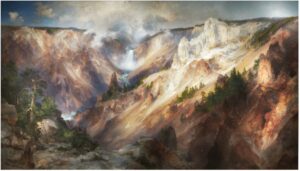
The Grand Canyon of the Yellowstone†
Introduction
“[N]estled within the largest relatively intact temperate zone ecosystem on the planet,” the Yellowstone begins its life as a river in an area where millions of people flock every year to fall head over heels in love with the place: the Greater Yellowstone Ecosystem.[1] The river’s headwaters lie in the Absarokas, near the southern edge of the first national park established in U.S. history, where the river carves the beyond‑words Grand Canyon painted famously by Thomas Moran to persuade Congress in 1872 to “[dedicate] and set apart as a public park, or pleasuring‑ground for the benefit and enjoyment of the people,” a sublime portion of the Yellowstone plateau.[2] Glancing farther downstream, the Yellowstone is “commonly referred to as the longest free‑flowing river in the lower 48 United States, as there are no major dams or reservoirs on the mainstem.”[3] For these superlative qualities and many others, this beautiful, life‑giving water body has been hailed as a “national resource . . . without parallel.”[4]
Native peoples have known the river since time immemorial. Its uppermost segment has been called lichìilikaashaashe (Elk River) by the Apsáalooke (Crow), carving Xakupkaashe (Big Canyon, Grand Canyon of the Yellowstone) and falling through that magical stretch, intensely and wonderfully, just downstream of lichìilikaashaase Ko’Bilichk’esh (Lake at Elk River, Yellowstone Lake)—or, as the Shoshone have referred to it, Bahn doy fooin (Water coming out).[5] No doubt these Native connections—this intergenerational place‑based knowledge—exist not just with respect to the Yellowstone in its majestic headwaters, but extend in equal measure to the entirety of the landscape encompassed by the river’s 71,000 square‑mile basin.[6] Tribal homelands span across and adjacent to this mixed landscape of high peaks and rolling plains, including those of the four tribal nations within the basin: the Eastern Shoshone and Northern Arapaho on the Wind River Reservation in present‑day Wyoming, and the Crow and Northern Cheyenne on their neighboring reservations in present‑day Montana.[7]
Driving this Article are a couple of observations about the basin tribes made by the late, great Charles Wilkinson, in his book The Eagle Bird, more than thirty years ago. What Charles had to say concerned the interstate compact applicable to the Yellowstone[8] and its tributaries, the Yellowstone River Compact,[9] and some unsettling aspects of the tribal nations’ circumstances under that document.[10] Charles couched his observations in ethical terms, rooting them in what he described as an “ethic of place,” for which he advocated in prose reflecting a deep love of western North America and a passionate and tireless commitment to realizing the region’s potential in inclusive, holistic, and evenhanded ways:
We need to develop an ethic of place. It is premised on a sense of place, the recognition that our species thrives on the subtle, intangible, but soul‑deep mix of landscape, smells, sounds, history, neighbors, and friends that constitute a place, a homeland. An ethic of place respects equally the people of a region and the land, animals, vegetation, water, and air. It recognizes that westerners revere their physical surroundings and that they need and deserve a stable, productive economy that is accessible to those with modest incomes. An ethic of place ought to be a shared community value and ought to manifest itself in a dogged determination to treat the environment and its people as equals, to recognize both as sacred, and to insure that all members of the community not just search for but insist upon solutions that fulfill the ethic.[11]
Channeling John Wesley Powell from a century prior,[12] Charles further suggested, “[t]he most relevant boundary lines for an ethic of place in the American West accrue from basin and watershed demarcations”—the Yellowstone River Basin and otherwise—while disavowing the notion of “rework[ing] our angular state lines to conform to river basins.”[13]
Applying this ethic of place to the Yellowstone River Compact, two aspects of the basin tribes’ circumstances troubled Charles, one having to do with marginalization of the tribes’ water rights, the other involving marginalization of the tribal nations as co‑sovereigns. As an initial matter, “tribal rights were expressly excluded from the compact,” and, “[a]s a result, many knowledgeable observers believe that the interstate allocation of the river may need to be reexamined in light of tribal water rights.”[14] Compounding this substantive concern, in Charles’s view, was a procedural matter. The body established to administer the compact, the Yellowstone River Compact Commission (the “Commission”),[15] consists solely of state and federal representatives, with no representation for the basin tribes. No legal barrier stood in the way of such representation, according to Charles, which if provided, would fully recognize “the tribes’ status as sovereign governments within the constitutional system.”[16] That is what Charles ultimately advocated, devoting a handful of paragraphs to the subject, “for a different kind of compact than those in the past,” with the end goal already identified: fulfillment of an ethic of place.[17]
Charles was not alone in recognizing these issues—as revealed nearly a quarter century later in Montana v. Wyoming, an original action before the U.S. Supreme Court from 2007 to 2018,[18] where the Northern Cheyenne, Montana, Wyoming, and North Dakota expressed contrary views on the status of tribal water rights under the Yellowstone River Compact. “Thankfully,” explained the Special Master, “it is ultimately unnecessary to decide how the Compact treats Indian rights in order to resolve the current dispute between Montana and Wyoming.”[19] The Special Master’s rationale was jurisdictional—neither the U.S. nor the tribe was a party or had waived sovereign immunity[20]—and the Justices agreed.[21]
From my perspective, the absence of tribal representatives on the Yellowstone River Compact Commission, as well as the uncertain, contested status of the basin tribes’ water rights under the compact, undermine the fundamental purpose for which interstate water compacts originated during the early twentieth century: “equitable apportionment”—that is, as alternative instruments for achieving equitable apportionment along interstate rivers rather than seeking U.S. Supreme Court decrees.[22] “Equitable division and apportionment” is plainly stated as one of the Yellowstone River Compact’s core purposes, alongside “interstate comity” and a desire “to remove all causes of present and future controversy . . . with respect to the waters of the Yellowstone River and its tributaries.”[23] Yet neither these purposes nor the basin tribes’ treatment distinguish the compact; rather, the marginalization just noted is systemic.[24]
Viewing equity as a synonym for fairness,[25] this Article contends that it is unfair for the Yellowstone River Basin’s tribal nations not to be represented directly alongside their federal and state co‑sovereigns on the Yellowstone River Compact Commission—if each tribe so wishes—and likewise that it is unfair for the status of the basin tribes’ water rights within (or outside) the compact’s apportionment to be left indeterminate. Equity should look different in the twenty‑first century—or, put another way, seventy‑five years into the compact’s life as a creature of law,[26] and more than a half‑century into the self‑determination era of federal Indian policy.[27] Equity is indeed a venerable norm for transboundary water law and policy, at both the domestic and international levels,[28] and making it real along the Yellowstone (and other rivers) at this point in time requires not only willingness to acknowledge historical injustices of water colonialism,[29] but, of equal importance, intentionality to approach future transboundary water management with proper respect for Indigenous peoples such as the Crow, Eastern Shoshone, Northern Arapaho, and Northern Cheyenne. That is what fundamentally needs to happen in my view, and the pages below gradually unfold this argument.
Conveying a sense of place is essential, especially for readers who care deeply and fervently about environmental justice, yet may not have had the privilege of spending time in the Greater Yellowstone Ecosystem or the vast expanse of basin and range country stretching northeasterly across the river’s basin.[30] Part I paints this picture. It focuses partly on the Yellowstone River Basin’s physical, political, and human geography, including the basin tribes’ reservations,[31] and partly on something currently garnering unprecedented attention: climate change and its impacts near the Yellowstone’s headwaters and across the Northern Plains.[32]
With the stage set in this way, the discussion shifts in Part II to compacts—the principal instruments forged under the U.S. Constitution to mediate co‑sovereign relations over transboundary rivers such as the Yellowstone.[33] Shedding light on their constitutional roots[34] and general nature as legal instruments,[35] the discussion delves into the specific compact at the heart of this piece. The Yellowstone River Compact’s genesis from 1932 to 1951 is surveyed,[36] followed by coverage of the contemporary eras of federal Indian policy,[37] and ultimately the compact’s legal architecture—specifically, its governance structure in Article III,[38] and its interstate apportionment and treatment of tribal water rights in Articles V and VI, respectively.[39] This overview serves as an essential backdrop for my advocacy addressing the marginalization highlighted above concerning “equitable division and apportionment.”[40]
Equity, as a norm and hopefully a reality, is where the discussion eventually leads in Part III. What exactly should “equity” mean in the context of interstate water compacts? Answers assuredly vary, and the Part begins by offering one way of thinking about this subject, a framework where equity is broken into procedural and substantive categories, both of which recognize how perceptions of fairness are shaped by multiple factors and inherently tied to historical context.[41] This framework is then applied to advocate for (1) representation of the basin tribes as co‑sovereigns on the Yellowstone River Compact Commission if they so wish,[42] and (2) clarification of the status of, and protection for, the basin tribes’ water rights under the compact’s apportionment.[43] In critical ways, both prescriptions involve the trust relationship shared by the U.S. and all tribal sovereigns, including the basin tribes, ever since this nation‑state’s founding.[44] So, too, are the prescriptions shaped by the current era of federal Indian policy—again, the self‑determination era—and the basic idea that equity needs to be conceptualized at present in ways that further rather than undermine key policy priorities of this era—namely, respect for tribal self‑governance, sovereignty, and self‑determination.[45]
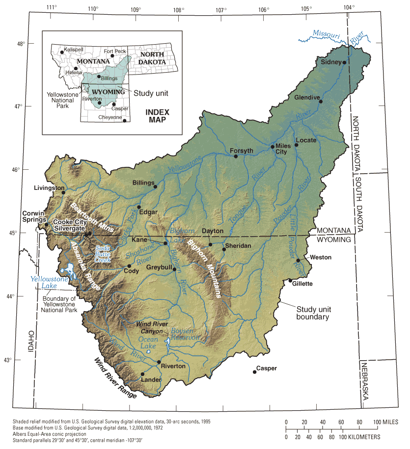
Looking ahead, this preview’s bird’s‑eye perspective dovetails with that provided by the map below—an entry point into the Yellowstone River and its vast basin.
Figure 1. Yellowstone River Basin[46]
I. lichìilikaashaashe & Its Basin
It is impossible, at least for me, not to visualize the headwaters of the Yellowstone River—Yellowstone Lake, the Grand Canyon of the Yellowstone,[47] and adjacent high‑altitude areas of the Greater Yellowstone Ecosystem[48]—when thinking about the future of the interstate compact apportioning use of the river system’s flows, including the compact’s treatment of Native peoples and their water rights. This place truly is magical, and the discussion below aims to capture some of its captivating character while also surveying the critical topic of climate change and its historical and projected impacts within the basin.
A. Sense of Place
Originally referred to as the “Roche Jaune” (“Yellow Rock”), the Yellowstone River’s name reflects a translation of the Native term Mi tse a‑da‑zi,[49] accounting for the “long miles of seething river flow[ing] past high cliffs of yellow sandstone.”[50] The nearly 700‑mile‑long river is one of stark contrasts—put differently, topographical relief is large.[51] Within its Grand Canyon,[52] Yellowstone Falls (Upper and Lower) embody the river’s dynamic and incisive character in its upper reaches, dropping nearly 2,000 feet in the initial ten miles of its descent from the slopes of Younts Peak (elevation 12,156 feet),[53] flattening out across a roughly 60‑mile section where it forms North America’s largest high‑elevation lake,[54] and then abruptly plunging another 1,200 feet through the Grand Canyon of the Yellowstone to the national park’s northern boundary.[55] Downstream of Livingston, Montana, the scene is much different, with the river meandering northeasterly at a mellowed gradient and lowering in elevation to 3,000 feet at Billings, 2,800 feet at its confluence with the Big Horn River, and 1,850 feet at its mouth.[56]
Mirroring this contrasting character are the Yellowstone’s tributaries—the Clarks Fork, Wind/Bighorn, Tongue, and Powder rivers—and the basin encompassing the river system as a whole. With headwaters in the Absaroka, Beartooth, Bighorn, and Wind River ranges,[57] the tributaries follow the general pattern just sketched, descending from breathtaking, high‑elevation peaks to lower‑lying interior valleys and plains, and flowing northeasterly in varied ways to join the Yellowstone River as it stretches across southeastern Montana to its confluence with the Missouri River at North Dakota’s far western edge.[58] At this spot, with all tributaries having joined the mainstem, the Yellowstone River contributes about 55 percent of the Missouri River’s water volume and constitutes its largest tributary.[59] Overall, the 71,000 square‑mile basin is a place where the Rocky Mountains and Great Plains meet,[60] with roughly 51 percent of the land base in Montana, 48 percent in Wyoming, and 1 percent in North Dakota.[61]
While no large‑scale dams and reservoirs impound the Yellowstone River itself, water infrastructure does exist across the basin,[62] most prominently in its western headwaters.[63] Total basinwide storage capacity is approximately 3,450,000 acre‑feet—2,010,000 acre‑feet in Wyoming, and 1,446,400 acre‑feet in Montana.[64] Along the Yellowstone, “irrigation diversions composed of rock or concrete typically block or partially block the main channel,” with “several large pump stations on the channel banks and dozens of small pumps and headgates” supporting irrigation.[65] More monumental in stature, the highest dam of the entire Missouri River Basin, the 525‑foot Yellowtail Dam, stretches as a massive concrete arch across the Bighorn River, roughly one hundred miles upstream of its confluence with the Yellowstone, forming an extensive reservoir, Bighorn Lake, with 1,331,725 acre‑feet of storage capacity.[66] Upstream counterparts in the Wind/Bighorn Basin include Buffalo Bill Dam and Reservoir along the Shoshone River and Boysen Dam and Reservoir along the Wind River, bearing storage capacity of 644,540 and 745,851 acre‑feet, respectively.[67] Farther to the east, on the other side of the Bighorns, lies Tongue River Dam and Reservoir, with 79,070 acre‑feet of storage capacity.[68]
These dams and reservoirs enable a variety of beneficial uses of the river system’s flows by human beings, but neither the plumbing nor other aspects of the human presence have come without costs to ecosystems.[69] In a host of ways, the water infrastructure and related human activities have impacted aquatic and riparian ecosystems throughout the basin:
The Yellowstone River’s natural snow‑melt driven hydrograph has been altered, [its] longitudinal, lateral, and main stem to tributary connectivity has been reduced, a variety of structures such as bank revetments (i.e., riprap), flow deflection structures (barbs, jetties, spur dikes, etc.) and flow confinement structures (i.e., levees, berms, dikes, etc.) have been installed along the banks and in the floodplain, and several nonnative fish are present. In addition, the riparian zone has been invaded by a number of invasive plant species such as Russian Olive and Salt Cedar that can have significant adverse effects on terrestrial habitat near water bodies.[70]
In terms of flow levels, the Yellowstone River Basin produces an estimated average of ten million acre‑feet annually.[71] Roughly 80 percent of this runoff originates in Wyoming’s mountains and flows into Montana through the tributaries just mentioned—from west to east, the Clarks Fork, Wind/Bighorn, Tongue, and Powder rivers.[72] Approximately 20 to 25 percent of the runoff is consumed each year.[73] Reflective of the landscape’s rural character—Billings, Montana being the largest community with 117,116 of the basin’s roughly 320,000 residents[74]—more than 90 percent of basinwide withdrawals go to irrigated agriculture.[75]
With respect to water quality, “[a]s the cumulative drain for the basin, the Yellowstone River integrates water quality characteristics of all land uses and human activities in its many tributaries.”[76] Water‑quality‑impaired river segments and lakes or reservoirs exist throughout the basin,[77] and significant water quality issues affecting both surface water and groundwater include trace elements, toxic compounds, salinity, sedimentation, bacteria, and nutrient concentrations.[78]
The three states through whose territory the Yellowstone River and its tributaries run (basin states) were identified above: Montana, Wyoming, and North Dakota. Large and rectangular, in whole or part, these states were etched onto the western landscape in 1889 and 1890,[79] close to a century after the U.S. entered into the 1803 Louisiana Purchase with France.[80] It was only a few years later that William Clark carved his signature into Pompeys Pillar along the Yellowstone during the Corps of Discovery’s 1806 return from the Pacific,[81] and John Colter took leave of the expedition to undertake his unrecorded excursions into the Yellowstone country (“Colter’s Hell” and elsewhere) during 1807 and 1808.[82] A provision of the Enabling Act facilitating Montana’s and North Dakota’s statehood is notable:
[T]he people inhabiting said proposed States do agree and declare that they forever disclaim all right and title to the unappropriated public lands lying within the boundaries thereof, and to all lands lying within said limits owned or held by any Indian or Indian tribes; and that until the title thereto shall have been extinguished by the United States, the same shall be and remain subject to the disposition of the United States, and said Indian lands shall remain under the absolute jurisdiction and control of the Congress of the United States.[83]
The Montana and North Dakota constitutions incorporate this provision.[84] Wyoming also included it in its constitution,[85] though the provision did not appear in its statehood act.[86]
Native peoples’ presence in the Yellowstone River Basin, of course, traces back millennia, to time immemorial,[87] and can be gleaned in modern times by (among other things) the three reservations on which the basin tribes reside. Uniformly, these reservations had been created before Montana, Wyoming, and North Dakota became states.[88] In Wyoming’s portion of the basin lies the Wind River Reservation, on which the Eastern Shoshone and Northern Arapaho reside, created by the Second Treaty of Fort Bridger in 1868.[89] The Wind River and its tributaries flow down the eastern slope of the same‑named mountain range through this reservation and eventually into Boysen Reservoir.[90] Established almost contemporaneously by treaty in 1868,[91] the Crow Reservation sits farther north in the Wind/Bighorn Basin, abutting the state line from the Montana side.[92] The Crow Reservation contains Yellowtail Dam—impounding the Bighorn River into Bighorn Lake for seventy‑one miles upstream[93]—as well as tributary segments such as the Little Bighorn River.[94] Immediately to the east of the Crow Reservation is the Northern Cheyenne Reservation—created by executive order in 1884[95]—whose eastern boundary is marked by the Tongue River just downstream of Tongue Reservoir.[96]
B. Sense of Change
The Yellowstone River Basin’s climate has been changing. The metrics of Western science used to track this pattern dovetail with what Crow elders have shared during interviews about changes they have observed in weather patterns and ecosystems across their lifetimes: “[F]ar less snowfall and milder winters, increased spring flooding, hotter summers,” and “extreme, unusual, and unpredictable weather events, compared to earlier times when seasons were consistent year after year.”[97] Fairly dense and quantitative in nature, the discussion below details how the river system of today (and tomorrow) differs from 1950 when the Yellowstone River Compact was drafted, as well as how a host of serious climate‑related water management issues confront the basin—and thus, inherently, the compact itself.
Serving as a fitting entry point for this material is, again, the theme of contrasts, in this case as it relates to basinwide temperature and precipitation. “Climate in the Yellowstone River Basin ranges from cold and moist in the mountainous areas to temperate and semiarid in the plains areas.”[98] Specifically, “[a]nnual temperature extremes range from about ‑40°F during the winter to hotter than 100°F during the summer,”[99] while “[m]ean annual temperatures range from less than 0ºC (32ºF) to 10ºC (50ºF).”[100] Temperatures are coldest in January (averaging from ‑18 degrees Celsius (0 degrees Fahrenheit) to ‑3 degrees Celsius (27 degrees Fahrenheit)) and warmest in July (averaging from 12 degrees Celsius (54 degrees Fahrenheit) to 24 degrees Celsius (75 degrees Fahrenheit)).[101] Precipitation, too, varies widely, in both quantity and form. “Mean annual precipitation ranges from more than 70 inches at high elevations in the mountains near Yellowstone National Park . . . to 5.5 inches in the central parts of the Bighorn and Wind River Basins.”[102] Snowpack is the source of most runoff,[103] as discussed further below, and “average annual snowfall rang[es] from less than 12 inches in parts of the Bighorn Basin to more than 200 inches near Yellowstone National Park.”[104] The headwaters mountains store water from October through May, and “[t]his water is released in April through August, with most runoff occurring in the spring‑summer snowmelt flood that typically peaks in mid to late June.”[105] In contrast, “[o]ther streams originate in the plains,” many of which are intermittent or ephemeral, such that “sporadic higher flows are the result of local snowmelt or intense rainstorms.”[106]
The Yellowstone River Basin’s foregoing variability should not be viewed as implying stationarity across time, particularly with respect to climate change’s historical and projected impacts on temperature. Mean annual temperature in the portion of the basin above Billings, Montana, has increased steadily since the mid‑twentieth century, from about 37 degrees Fahrenheit in 1950 to 40 degrees Fahrenheit in 2014.[107] Looking ahead, projections for future temperature increases in this portion of the basin vary by model and scenario, with a median increase of 2.9 degrees Fahrenheit and a range of 1.2 to 4.9 degrees Fahrenheit for the 2010 to 2059 period, as compared to the 1950 to 1999 period.[108] Similar observations and projections can be found in climate research on the Greater Yellowstone Area (GYA), including the Upper Yellowstone and Big Horn watersheds.[109] Across the GYA, “[t]he average temperature of the last two decades (2001–2020) is probably as high or higher than any period in the last 20,000 [years], and likely higher than previous glacial and interglacial periods in the last 800,000 [years].”[110] Further, since 1950, “[m]eteorological records, averaged across the GYA, show that the mean annual temperature in the GYA has increased by 2.3 degrees Fahrenheit (1.3 degrees Celsius) at a rate of 0.35 degrees Fahrenheit (0.19 degrees Celsius) per decade.”[111] While there is variation among models and scenarios, this pattern is projected to continue going forward, with GYA temperatures increasing, as compared to the 1986 to 2005 period, by 5.3 degrees Fahrenheit under one pathway (RCP4.5) and 10.0 degrees Fahrenheit under another pathway (RCP8.5), by 2099.[112] Projected temperature increases for the Upper Yellowstone and Big Horn watersheds track these projections for the entire GYA.[113] This trend, historical and projected, has significant implications for water management across the basin, particularly the agricultural sector, including an extended growing season,[114] increased evaporation from soil and reservoirs, and increased evapotranspiration by irrigated crops and natural vegetation.[115]
Climate change also has impacted, and is projected to continue impacting, basin‑wide precipitation.[116] Annual precipitation appears to have increased slightly above Billings, Montana since the mid‑twentieth century, from about 25 to 27 inches annually.[117] Looking ahead, projections for future precipitation in this area vary more than those for temperature. The median projection for the 2010 to 2059 period, relative to the 1950 to 1999 period, is an increase of 1.1 inches (2.4 percent).[118] Within the GYA, annual precipitation averaged 26.7 inches from 1986 to 2005.[119] Moving forward, projected precipitation differs in extent but not general trajectory. Relative to the 1986 to 2005 period, mean annual precipitation in the GYA is projected to increase 7 percent by mid‑century (2041–2060) and 8 percent by the end of century (2081–2099) under the RCP4.5 pathway.[120] Over the same periods, but under the RCP8.5 pathway, the projected increases are 9 and 15 percent, respectively.[121] Projected precipitation increases within the Upper Yellowstone and Big Horn watersheds resemble these projections for the whole GYA.[122]
These precipitation figures are closely intertwined with those addressing climate change’s impacts on snowfall—as noted, “[s]nowfall is the primary source of runoff to the Yellowstone River.”[123] Temperature and snowfall have an inverse relationship: “As the climate has warmed, mean annual snowfall in the GYA has declined by 3.5 inches” per decade, and much of this decline has occurred in spring when warming has been greatest.[124] Snowfall declines within the GYA have been pronounced in January and March,[125] and “the snow‑free season has lengthened[,] with snow accumulation in June and September declining to near zero.”[126] All told, from 1950 to 2018, there was a 24‑inch decrease in annual snowfall across the GYA, including a 7.4‑inch decrease in the Big Horn watershed, yet a 1.4‑inch increase in the Upper Yellowstone watershed.[127] This pattern reflects the trend across the Northern Rockies: “Warmer spring temperatures coupled with increased variability of spring precipitation correspond strongly to earlier snow melt‑out, an increased number of snow‑free days, and observed changes in streamflow timing and discharge.”[128] As the twenty‑first century progresses, snowfall is projected to continue decreasing across the GYA, again subject to variation among models and scenarios. Specifically, under the RCP4.5 pathway, the portion of the GYA dominated by winter snowfall is projected to decrease from 59 percent during the 1986 to 2005 base period to 27 percent at mid‑century (2041–2060)[129] and 11 percent by the end of century (2081–2099).[130] Even more drastic, under the RCP8.5 pathway, the extent of snow‑dominant area across the GYA is projected to decrease to 17 percent and 1 percent, respectively, for the same periods.[131] Similar projections exist for the Upper Yellowstone and Big Horn watersheds.[132]
What do these changes mean for runoff in the Yellowstone River system? Here is a useful encapsulation: Rather than the river system’s flows being stationary in coming decades, “[a]n overwhelming preponderance of scientific evidence shows that the future envelope of streamflow variability will differ from the historical. . . . [S]treamflow is likely to change, in amount, timing and distribution.”[133] With respect to the headwaters, data for the Yellowstone River at Livingston, Montana, reveal that “over the past 15 years, runoff has typically started about a week earlier and peaked 10 days earlier than it typically did between 1896 and 1990.”[134] On a state-wide basis in Montana, including along the Yellowstone, “virtually all model simulations developed in support of the state water plan project predict earlier runoff and reduced summer flows.”[135] The GYA climate research is similar. From 1950 to 2018, peak streamflow occurred eight days earlier across the GYA as a whole, twelve days earlier in the Upper Yellowstone watershed, and one day earlier in the Big Horn watershed.[136] Looking ahead to 2100, summer runoff is projected to decline by 35 percent across the entire GYA, and by 32 percent and 36 percent in the Big Horn and Upper Yellowstone watersheds, respectively.[137] In addition, as alluded to above, the growing season is projected to extend forty days longer in the Big Horn watershed and thirty‑five days longer in the Upper Yellowstone watershed by 2100.[138]
Much more could (and should) be said about climate change within the Yellowstone River Basin, but hopefully this discussion hits some of the high points, historical and projected, including the conjoined, pronounced basin‑wide increases in temperatures, declines in snowfall, and declines in summer runoff. Simply put, climate change is water change along the Yellowstone—the river of 1950 is not the river of 2025 or 2100—and stakeholders understandably have expressed anxiety about future water management.[139] “We conducted a survey with all of our 850 rural families,” described a tribal member in the Upper Yellowstone watershed, “and their biggest concern is water. Water is a big concern for everybody.”[140] It is a truism to say that this concern bears directly and in multifaceted ways on the interstate water compact developed amidst the Cold War to allocate the river system’s flows.
II. Of Cold Wars & Domestic Water Treaties
Thinking about what future water management might look like along the Yellowstone not only requires surveying the physical landscape as outlined above but also the legal landscape as canvassed below, particularly the now seventy‑five‑year‑old Yellowstone River Compact. An initial aspect of this task involves delving into legal history, both pertaining to the compact’s formation, as well as contemporary federal Indian policy. Against this historical backdrop, a subsequent and equally essential aspect entails analyzing the compact’s legal architecture—specifically, the design of its governance structure and apportionment, including its respective treatment of the basin’s tribal sovereigns and their water rights.
A. Vignette of the Yellowstone River Compact’s Genesis
Putting together a compact for the Yellowstone River system was no small feat during the mid‑twentieth century. In the big picture, this protracted endeavor can be traced to a taxing and suboptimal experience endured by a famous attorney from Greeley, Colorado, Delph Carpenter, the “father of interstate water compacts,”[141] hammering out interstate relations over the Laramie River before the U.S. Supreme Court in Wyoming v. Colorado.[142] Responding to this litigation, Carpenter (a.k.a. the “Silver Fox of the Rockies”)[143] initially proposed during the early 1920s navigating western states’ relations over interstate rivers by utilizing the U.S. Constitution’s Compact Clause,[144] rather than invoking the Supreme Court’s original jurisdiction.[145] Carpenter’s advocacy clearly articulated his views on federalism in regard to Western water and, concomitantly, the fundamental nature of interstate compacts as then‑novel legal instruments:
If the separate sovereignties (the States) in Union only for Federal purposes have and do possess and exercise the powers to formulate and conclude binding conventions between each other and between one or more thereof and the Federal Government respecting boundaries, fisheries, harbor control and pollution, interstate easements and servitudes, and like subjects, there can be no logical objection to the application of like methods of solution to all problems growing out of the use and distribution of the waters of interstate streams. . . . All such problems respecting international rivers are settled by conventions between the nations whose territory is involved. The factors which prompt such methods between independent nations should apply between States of separate sovereignties and exclusive jurisdictions, yet bound together in a Federal Union of limited and delegated powers under a Constitution of their own creation.[146]
Carpenter’s theorizing here forever shaped the contours of Western water law.
Fast‑forwarding nearly three decades, Carpenter’s view of compacts as domestic water treaties provides a well‑suited backdrop for the Yellowstone River Compact’s formation. Steeped in parochialism and frustration, witness the remarks of an unnamed Montana resident, read into the congressional record on August 26, 1949, responding to statements by former Wyoming State Engineer L.C. Bishop[147] that had expressed support for forming a compact for the Yellowstone River system, in lieu of U.S. Supreme Court litigation:
To go back to Mr. Bishop again, he says that he doesn’t believe the States should have a lawsuit over this water, but that they should continue to try to negotiate compacts. This particular compact appears to me to be about the same thing as one would experience in trying to negotiate a compact with Joe Stalin. As far as I am concerned, the two States have been involved in a cold war for some time.[148]
During the roughly thirty‑year period between Delph Carpenter’s early advocacy for interstate water compacts and that Montana resident’s “cold war” remarks, a compact had begun to emerge, albeit in fits and starts, for the Yellowstone River system. To put a finer point on it, in its current form, “[t]he Yellowstone River Compact is the result of three earlier attempts to get an agreement on the allocation and use of the waters of the Yellowstone Basin.”[149]
Across this period, from 1932 to 1951, a familiar motive notably persisted, one common across Western water compacts. The Yellowstone River Compact’s formation was not an abstract exercise in collaborative design of transboundary water institutions, but rather a prerequisite for federally supported basin‑wide water infrastructure and development.[150]
With this motive ever present, the first round of compact negotiations spanned the mid‑1930s, commencing on June 14, 1932, when Congress authorized Montana and Wyoming to enter into a compact “for an equitable division and apportionment . . . of the water supply of the Yellowstone River and of the streams tributary thereto.”[151] January 1, 1936, was set as a deadline.[152] It came and went. Commissioners for Montana and Wyoming, as well as a commissioner for the U.S., negotiated and signed a compact in Cheyenne on February 6, 1935.[153] But as described several years later by former Wyoming Governor Lester C. Hunt: “We have no record of this [compact] having been submitted to the State Legislatures for ratification.”[154] Thus ended the first attempt.
The next foray—the second round of compact negotiations—stretched from 1937 to 1942. Congress’s authorization of negotiations on August 2, 1937, resembled its counterpart five years prior, imposing June 1, 1939, as a deadline for Montana and Wyoming to form a compact “for an equitable division and apportionment . . . of the water supply of the Yellowstone River and of the streams tributary thereto.”[155] Yet a couple things changed as this stretch of the negotiations ran its course. The original deadline went unmet as before, and thus was amended to June 1, 1943, and North Dakota also was authorized to participate in the negotiations.[156] Notwithstanding these developments, no compact ultimately made it over the finish line. On New Year’s Eve of 1942, a compact was signed by the commissioners in Billings, Montana, but the legislatures of that state and North Dakota later declined to ratify it.[157]
Likewise, contrary to the old saying, the third round of negotiations was not a charm. Congress extended to June 1, 1947, the deadline for negotiating a compact for the Yellowstone River system, in this instance with Montana, Wyoming, and North Dakota all participating from the outset.[158] Less than a year passed before the state commissioners, joined by the commissioner for the U.S., negotiated and signed another compact in Billings.[159] Following the turn of the year, in early 1945, the Montana, Wyoming, and North Dakota legislatures each ratified the compact.[160] But still it was not to be, as Wyoming’s governor vetoed it.[161]
It was in this specific context—seventeen years after Congress initially had authorized compact negotiations, and five years after the 1944 version had failed to come into being—that the remarks of the unnamed Montana resident mentioned above, analogizing the experience to a “cold war” with “Joe Stalin,” were read into the congressional record.[162] Roughly three months earlier, on June 2, 1949, Congress yet again had given its blessing for Montana, Wyoming, and North Dakota to enter into a compact “providing for an equitable division and apportionment . . . of the water supply of the Yellowstone River and of the streams tributary thereto.”[163] A deadline of June 1, 1952, had been set and, on this occasion, it did not go by the wayside. A sequence of formal meetings was held in Billings on November 29, 1949; February 1–2, 1950; October 24–25, 1950; and December 7–8, 1950.[164] At the last meeting’s close, the state commissioners signed the compact,[165] setting the stage for the final hurdle, federal and state ratification, in what at that point had become a nearly two‑decade‑long project. All told, the basin states’ legislatures ratified the compact, with their respective governors conferring approval, during the first few months of 1951.[166] Congress followed suit—as required by the U.S. Constitution’s Compact Clause[167]—about six months later, on October 30, 1951.[168]
What exactly did this nearly two‑decade‑long endeavor yield? How did the version of the compact finalized in 1951 call for apportioning use of the Yellowstone River system’s flows, and who would have a hand in administering the apportionment, including resolving potential conflicts over it? These questions point to where the discussion now turns.
B. “Equitable Division & Apportionment”
As identified earlier, not only did the phrase (norm, really) “equitable division and apportionment” appear throughout Congress’s acts authorizing negotiation of a Yellowstone River Compact from 1932 to 1951,[169] the phrase also cannot be missed in a portion of the compact’s preamble expressing the basin states’ desire “to provide for an equitable division and apportionment” of the “waters of the Yellowstone River and its tributaries.”[170] This foundational goal cannot be separated from the particular approaches taken by state and federal negotiators when shaping the compact’s governance structure and apportionment. Further, how equity was conceived in these respects—as an aspirational norm and vis‑à‑vis the governance structure and apportionment—inherently reflects the time and space in which the compact was formed, including the contemporary eras of federal Indian policy.
1. Federal Indian Policy: Allotment & Assimilation to Termination Eras
To elaborate, while the discussion below delves into key features of the Yellowstone River Compact’s governance structure and apportionment involving equity (procedural and substantive),[171] it should be highlighted at the outset that the compact’s negotiation commenced at the seam of two eras of federal Indian policy—the allotment and assimilation era followed by the Indian reorganization era—while the compact’s ultimate adoption took place during the termination era.[172] Analogous to a pendulum’s swing,[173] the shift in policy across these eras reveals approaches to Native American affairs that contrast starkly not only with one another, but also with the self‑determination era[174]—the modern era in which the compact’s commitment to equity must be implemented, including in relation to the basin tribes.
Turning initially to the allotment and assimilation era, it began with the 1887 Dawes Act,[175] “civilization and assimilation” being the prevailing theme—one implemented by “legislation providing for the acquisition of Indian lands and resources” and rationalized as serving Native people’s best interests.[176] “Civilization” meant their acculturation to Euro‑American institutions such as Christianity, private property, agriculture, and the English language, while “assimilation” contemplated Native peoples’ adoption of these institutions, as well as privatization of tribally‑held reservation lands and transfer of non‑privatized “surplus” lands into non‑Indian ownership.[177] This policy was a failed social experiment.[178]
With the Meriam Report’s release in 1928,[179] followed by passage of the Indian Reorganization Act (IRA) in 1934,[180] federal policy shifted. “[N]ew policies were advocated by organizations and individuals who spoke and published their doubts about allotment and assimilation.”[181] Sparking this policy shift, the Meriam Report drew attention to Native peoples’ deplorable living conditions, and “defined the goal of Indian policy as the development of all that is good in Indian culture,” rather than the “crush[ing] out [of] all that is Indian.”[182] The IRA, the era’s “crowning achievement,”[183] set forth this prohibition: “[H]ereafter no land of any Indian reservation, created or set apart by treaty or agreement with the Indians, Act of Congress, Executive order, purchase, or otherwise, shall be allotted in severalty to any Indian.”[184] Allotment ended. Beyond that milestone, the IRA provided for the adoption of tribal constitutions and bylaws (subject to secretarial approval),[185] as well as tribal charters of incorporation (subject to secretarial petition),[186] and although not all tribes favored these measures,[187] the IRA has been hailed as “key to the New Deal’s attempt to encourage economic development, self‑determination, cultural pluralism, and the revival of tribalism.”[188]
Then the policy pendulum swung back with the advent of a new era, “termination,” whose label carries connotations that speak for themselves.[189] Spanning from the mid‑1940s to the early 1960s, this era involved “the most concerted drive against Indian property and Indian survival since the removals following the act of 1830 and the liquidation of tribes and reservations following 1887.”[190] Most notably, the unique, longstanding trust relationship between tribal nations and the United States was put in the crosshairs.[191] “[F]ederal policy dealing with Indian lands and reserves during the termination era focused primarily on ending the trust relationship between the United States and Indian tribes, with the ultimate goal being to subject Indians to state and federal laws on exactly the same terms as other citizens.”[192] To this end, Congress adopted in 1953 House Concurrent Resolution 108—whose policy statement “dominated Indian affairs for most of the next decade”[193]—and enacted subsequent legislation terminating previously federally recognized tribes and bands (e.g., seventy tribes and bands in 1954 alone).[194] As with allotment, the end results for terminated tribes and Native individuals were “tragic,” including cessation of federal trusteeship over landholdings; discontinuation of federal health, welfare, housing, and other social programs; and imposition of state jurisdiction (adjudicatory and legislative) and state taxation.[195]
Far more could be said about these shifts in federal Indian policy surrounding the 1932 to 1951 period during which the Yellowstone River Compact took shape. For present purposes, the takeaway goes back to “equitable division and apportionment,” as that aspirational phrase appears in the compact’s preamble.[196] The “whipsawing”[197] policy eras are an important aspect of the compact’s historical context—or, put differently, how state and federal negotiators (and others) perceived equity, including in relation to Native peoples such as the Crow, Eastern Shoshone, Northern Arapaho, and Northern Cheyenne. Such perceptions are reflected in the particular features of the compact’s governance structure and apportionment.
2. Governance Structure: Yellowstone River Compact Commission
Starting with governance, Article III establishes the Yellowstone River Compact Commission for administration of the instrument between Montana and Wyoming, but not North Dakota.[198] This provision lays a foundation for the Commission’s composition, powers and duties, as well as dispute resolution processes.[199]
With respect to composition, the Yellowstone River Compact Commission is a three‑member body.[200] One representative each from Montana and Wyoming are selected by the respective governors and, if requested by the states, one federal representative is selected by the Director of the U.S. Geological Survey.[201] Both state representatives wield voting power, but the federal representative generally lacks it, subject to one exception covered below.[202] If appointed, the federal representative serves as Commission chair.[203] In addition to these representatives, the compact calls for various federal officials (e.g., the Interior Secretary and Secretary of the Army) to cooperate ex officio with the Commission “in the collection, correlation, and publication of records and data necessary for the proper administration of the Compact.”[204]
The term “jurisdiction” is used to refer to the Yellowstone River Compact Commission’s powers and duties.[205] They include “the collection, correlation, and presentation of factual data, the maintenance of records having a bearing upon the administration of [the] Compact, and recommendations to such States upon matters connected with” compact administration.[206] Further, as set forth in a separate provision, the Commission is empowered “to formulate rules and regulations,” including amending them, and “to perform any act which [the Commission] may find necessary to carry out the provisions of [the] Compact.”[207]
The compact also outlines in Article III(F) a dispute resolution process for the Commission and, as alluded to above, the federal representative is positioned, at least per the provision’s text, in a tie‑breaking role.[208] The compact negotiators envisioned situations where the state representatives might not “unanimously agree” on matters “necessary to the proper administration” of the compact.[209] Faced with such impasses, the compact vests the federal representative with a tie‑breaking vote—specifically, the federal representative “shall have the right to vote upon the matters in disagreement,” and “such points of disagreement shall then be decided by a majority vote,” with each representative entitled to one vote.[210]
It is important to highlight that Article III(F)’s dispute resolution provision does not stand alone—in at least two related ways. First, acting under its authority “to formulate rules and regulations” for compact administration,[211] the Yellowstone River Compact Commission in 1995 adopted Rules for the Resolution of Disputes over the Administration of the Yellowstone River Compact.[212] Intended to clarify and flesh out Article III(F)’s text, these dispute resolution rules emphasize “joint problem solving and consensus building,” and generally put into place a three‑phase process consisting of unassisted negotiation,[213] facilitation,[214] and voting.[215] Second, with respect to this process’s voting phase, the federal representative notably adheres to an abstention policy, whereby that official will not cast a tie‑breaking vote on administrative matters about which the state representatives disagree.[216] Tension exists between this policy and the dispute resolution process contemplated by Article III(F)’s text; however, this tension apparently has existed as a governance issue since at least the mid‑1980s.[217]
3. Interstate Apportionment & Tribal Water Rights
Shifting from governance to apportionment, two compact provisions, Articles V and VI, are instrumental in prescribing how the use of water is apportioned across the basin. Both provisions rest on the compact’s definition of “Yellowstone River System”: “the Yellowstone River and all of its tributaries, including springs and swamps, from their sources to the mouth of the Yellowstone River near Buford, North Dakota, except those portions thereof which are within or contribute to the flow of streams within the Yellowstone National Park.”[218]
With the compact’s hydrological scope delineated in this way, Article V establishes a three‑tier apportionment for Montana’s and Wyoming’s portions of the basin upstream of Intake, Montana,[219] excluding from the apportionment domestic uses and certain stock water uses—for example, if the capacity of a stock water reservoir is twenty acre‑feet or less.[220]
Atop the apportionment’s first tier are pre‑1950 appropriative rights. Specifically, as spelled out in Article V(A): “Appropriative rights to the beneficial uses of the water of the Yellowstone River System existing in each signatory State as of January 1, 1950, shall continue to be enjoyed in accordance with the laws governing the acquisition and use of water under the doctrine of appropriation.”[221]
Article V(B), in turn, carves out a second tier consisting of supplemental water supplies for pre‑1950 appropriative rights along the interstate tributaries (Clarks Fork, Bighorn, Tongue, and Powder rivers),[222] stating:
Of the unused and unappropriated waters of the Interstate tributaries of the Yellowstone River as of January 1, 1950, there is allocated to each signatory State such quantity of that water as shall be necessary to provide supplemental water supplies for the rights described in [Article V(A)], such supplemental rights to be acquired and enjoyed in accordance with the laws governing the acquisition and use of water under the doctrine of appropriation.[223]
Following this text, Article V(B) goes on to establish a third tier of post‑1950, percentage‑based rights along the interstate tributaries, providing: “[T]he remainder of the unused and unappropriated water is allocated to each State for storage or direct diversions for beneficial use on new lands or for other purposes” on a percentage basis.[224] The specific splits along each tributary are as follows: Clarks Fork (Montana, 40 percent; Wyoming, 60 percent), Bighorn River (Montana, 20 percent; Wyoming, 80 percent), Tongue River (Montana, 60 percent; Wyoming, 40 percent), and Powder River (Montana, 58 percent; Wyoming, 42 percent).[225]
These allocations notably are not set in stone. Rather, the Yellowstone River Compact Commission is authorized, “[f]rom time to time,” to “re‑examine the allocations . . . and upon unanimous agreement . . . recommend modifications . . . as are fair, just, and equitable.”[226] “Priorities of water rights” are one factor within an inexhaustive list enumerated by the compact for such modifications, alongside “[a]creage irrigated,” “[a]creage irrigable under existing works,” and “[p]otentially irrigable lands.”[227]
While Article V is fairly detailed in mapping out its three‑tier apportionment, Article VI on tribal water rights consists of one sentence: “Nothing contained in this Compact shall be so construed or interpreted as to affect adversely any rights to the use of the waters of [the] Yellowstone River and its tributaries owned by or for Indians, Indian tribes, and their reservations.”[228] This disclaimer is the only compact provision expressly addressing tribal water rights. Viewed in historical context, the U.S. Supreme Court had recognized in its 1908 Winters decision, handed down more than forty years before the compact’s adoption, the existence of an Indian reserved right for the Fort Belknap Reservation in Montana, reasoning that because water was necessary to fulfill the purpose for which the Reservation had been established, a reserved right had been created implicitly upon the Reservation’s creation.[229] The Yellowstone River Compact’s negotiators were certainly familiar with Winters, both in general and as applied to the basin tribes’ reservations.[230] Nonetheless, Article VI’s one‑sentence disclaimer is what was ultimately penned and, as discussed further below,[231] gives rise to competing views on the provision’s interface with Article V.[232]
With this roadmap of the Yellowstone River Compact’s history and features (legal landscape) in mind, it is time to look towards the future. “Equitable division and apportionment” held whatever meaning it did for compact negotiators roughly seventy‑five years ago when they included that phrase (again, norm) in the preamble[233] and designed the governance structure and apportionment in their particular forms. Even more interesting and important, in my view, is to consider what “equitable division and apportionment” should mean, and how the norm could be realized to a greater extent, along the Yellowstone going forward.
III. “Equity” for Whom?
This line of inquiry animates the question posed by this Part’s title. Equity indeed may be in the eye of the beholder, but its subjectivity does not eviscerate its value as a norm for critiquing and suggesting reforms to interstate compacts or other instruments used to mediate co‑sovereign relations over transboundary waters.[234] The discussion below thus begins by delving further into the meaning of “equity” in this context, and then leverages that discussion—specifically, its coverage of two categories of equity, procedural and substantive—to revisit the Yellowstone River Compact’s legal architecture and the previously identified issues of concern amidst the self‑determination era of federal Indian policy. The Yellowstone River Compact Commission’s exclusion of tribal representatives is considered before turning to the unclear and contested status of tribal water rights within (or outside) the compact’s apportionment.
A. “Equity” as a Norm
It is one thing to highlight “equitable division and apportionment” as a fundamental goal in the Yellowstone River Compact’s preamble,[235] or in the various legislation authorizing the compact’s negotiation from 1932 to 1951.[236] It is another thing, however, to consider what exactly is packed into the norm underlying that phrase: equity. How should equity be conceptualized? Bearing not just on the compact, but on the entirety of transboundary water law and policy, this line of inquiry—conceptualization of equity—is critical for figuring out what human relationships over and with transboundary rivers such as the Yellowstone, as well as other water bodies, ought to look like in the future, including how interstate compacts and other water institutions ought to evolve.[237]
The Yellowstone River Compact’s emphasis on equity was not a one‑off—just the opposite—and this fact should be highlighted at the outset. Consider the foundational role played by equity within the broad and crucial field of international water law—specifically, the norm enshrined in the 1997 U.N. Watercourses Convention, “equitable and reasonable utilization and participation,”[238] recognized as customary law by the International Court of Justice.[239] That norm’s genesis at the international level, in turn, traces to the U.S. Supreme Court’s equity‑driven jurisprudence, amassing since the early twentieth century, addressing state sovereigns’ legal relations along interstate rivers—the Court’s equitable apportionment doctrine.[240] Wyoming v. Colorado is, again, one notable precedent within this jurisprudence[241] and, as mentioned earlier,[242] Delph Carpenter’s formative experience with that litigation forever shaped his views on alternative instruments for achieving equitable apportionment—interstate water compacts—in lieu of pursuing decrees from the Court.[243]
Beyond equity’s prevalence as a norm within transboundary water law and policy, what is even more critical for present purposes concerns how the norm is analyzed, at both the domestic and international levels. The frameworks run parallel. Announced in its 1945 Nebraska v. Wyoming decision, the U.S. Supreme Court has developed a multi‑factor framework for analyzing equitable apportionment, explaining that “apportionment calls for the exercise of an informed judgment on a consideration of many factors” (a “delicate adjustment of interests”), and clarifying that the factors enumerated within the framework “are merely an illustrative, not an exhaustive catalogue.”[244] This approach closely resembles that later adopted in the 1997 U.N. Watercourses Convention, which similarly contains an inexhaustive list of factors, without assigned relative weight, “all of which are to be considered together and a conclusion reached on the basis of the whole.”[245]
At least two takeaways should be gleaned from these analyses. First, equity is a context‑specific norm for transboundary waters. To devise an “equitable” apportionment along a given river (or other water body), the totality of the circumstances must be taken into account.[246] Second, as a corollary, time is an important dimension of this contextuality. As the context surrounding transboundary waters inevitably changes over time, a gap may widen between what equity seems to call for in the present versus what it was perceived to call for in the past, such as when an interstate compact was drafted espousing the goal of “equitable” apportionment.[247]
Beyond being context‑specific and pervasive in transboundary water law and policy, equity is also a norm encompassing two broad categories reflected in the phrase “equitable and reasonable utilization and participation”[248] from the 1997 U.N. Watercourses Convention: substantive equity and procedural equity.[249] To reiterate, equity is a synonym for fairness.[250] When thinking about the fairness of transboundary water institutions such as interstate compacts, one logical focus is the substance of an apportionment. For example, which types of parties are allocated water, what is the order of priority during shortages, how secure are different types of water rights, and so forth?[251] These questions capture what is referred to as “substantive equity” and associated principles such as reciprocity, fidelity, reliability, and flexibility.[252] In addition, a complementary angle for evaluating the fairness of transboundary water institutions is to consider the composition and processes of their governance structures. For example, which parties have a voice in decision‑making and which do not, how transparent are decision‑making processes, how effective is the particular structure in actually enabling governance, and so on?[253] These related questions reflect the essence of what has been called “procedural equity,” which involves principles such as inclusivity, diligence, and transparency.[254]
While there is no singular way of thinking about what the norm of equity means in transboundary water law and policy, the material above lays the foundation for my approach with regard to the Yellowstone River Compact. In its current form, nearly seventy‑five years after its genesis, the compact raises significant issues of procedural and substantive equity involving the basin tribes and their water rights. The existence of these issues, respectfully, throws into question whether the compact’s commitment to “equitable division and apportionment”[255] is just words on a page. For my part, I would like it to be more.
B. Reimagining “Equitable Division & Apportionment”
How exactly the Yellowstone River Compact might evolve to become more equitable is a topic that should be approached with humility and respect, especially insofar as the advocacy is intended to offer ideas to Crow, Eastern Shoshone, Northern Arapaho, and Northern Cheyenne tribal leaders and members. That is the spirit in which the pages below have been written. After putting the advocacy into context by discussing key features of the self‑determination era—the current era of federal Indian policy as noted earlier—the discussion turns to the equity‑related issues just alluded to. Regarding procedural equity, my overall prescription is that the Yellowstone River Compact Commission should be reconstituted in an updated form to allow for direct representation of each basin tribe, if so desired by the tribe. As for substantive equity, I advocate for the formation of a consensus‑based agreement that clarifies the status of, and ultimately protects, tribal water rights under the compact’s apportionment.
1. Federal Indian Policy: Self‑Determination Era
In modern times, the Yellowstone River Compact exists amidst the self‑determination era of federal Indian policy, which commenced during the 1960s.[256] With the allotment and assimilation era, as well as the termination era, having run their course, it is this distinct period in which the Yellowstone River Compact Commission is administering the instrument, including its provisions addressing the interstate apportionment and the basin tribes’ water rights.[257] As the U.S. Supreme Court has described, a congressionally approved compact is both an interstate contract and a federal statute.[258] It is, by definition, federal law. As such, however the Yellowstone River Compact’s laudable goal of “equitable division and apportionment”[259] is approached and hopefully realized in coming years, it should be in ways that comport with and further, not undermine, the self‑determination era’s key priorities.
A bit more should be said about the current era and those priorities. The Yellowstone River Compact had been in existence for about a decade before the proverbial pendulum of federal Indian policy swung away from the termination era and into the self‑determination era—an era marking “a return to much of the basic philosophy and many of the policy objectives rooted in the Indian reorganization era.”[260] As used in this context, “[s]elf‑determination” has been described as constituting “the strongest expression of [c]ongressional and [e]xecutive branch support for the development of tribal governments, reservation economies, and Indian people, as well as recognition of the importance of tribal sovereignty.”[261]
These defining priorities of the self‑determination era—respect for tribal self‑governance, sovereignty, and self‑determination—can be gleaned from numerous pieces of legislation and executive documents that have emerged since the 1960s, including President Nixon’s landmark message to Congress on July 8, 1970.[262] Calling for congressional renunciation, repudiation, and repeal of termination policy, Nixon acknowledged that “cultural pluralism is a source of national strength,”[263] and advocated in pathbreaking ways for tribal self‑governance. Specifically, he called for tribal sovereigns, if they desired, to be empowered to assume control and responsibility over federal programs historically administered on reservations by federal agencies.[264] Nixon referenced federally funded and administered programs within the Department of the Interior and the Department of Health, Education, and Welfare, expressly singling out tribal sovereigns’ control over their own schools.[265]
Fast‑forwarding more than a half‑century, President Biden issued an executive order in 2023 echoing much of what President Nixon had said to Congress in 1970.[266] This order’s policy section could be paraphrased but, in my view, deserves to be excerpted:
My Administration is committed to protecting and supporting Tribal sovereignty and self‑determination, and to honoring our trust and treaty obligations to Tribal Nations. We recognize the right of Tribal Nations to self‑determination, and that Federal support for Tribal self‑determination has been the most effective policy for the economic growth of Tribal Nations and the economic well‑being of Tribal citizens. Federal policies of past eras, including termination, relocation, and assimilation, collectively represented attacks on Tribal sovereignty and did lasting damage to Tribal communities, Tribal economies, and the institutions of Tribal governance. By contrast, the self‑determination policies of the last 50 years—whereby the Federal Government has worked with Tribal Nations to promote and support Tribal self‑governance and the growth of Tribal institutions—have revitalized Tribal economies, rebuilt Tribal governments, and begun to heal the relationship between Tribal Nations and the United States.
* * *
Now is the time to build upon this foundation by ushering in the next era of self‑determination policies and our unique Nation‑to‑Nation relationships, during which we will better acknowledge and engage with Tribal Nations as respected and vital self‑governing sovereigns. As we continue to support Tribal Nations, we must respect their sovereignty by better ensuring that they are able to make their own decisions about where and how to meet the needs of their communities. No less than for any other sovereign, Tribal self‑governance is about the fundamental right of a people to determine their own destiny and to prosper and flourish on their own terms.[267]
This text vividly captures the self‑determination era’s distinct character.
That said, one aspect of the current era not emphasized enough up to this point appeared in the Biden Administration’s commitment “to honoring our trust . . . obligations to Tribal Nations.”[268] This commitment grew out of the trust relationship shared by the U.S. and tribal sovereigns ever since our nation‑state’s founding.[269] Rooted in promises of protection made by the U.S. to tribal nations, explicitly or implicitly, in treaties and treaty substitutes,[270] the U.S. Supreme Court’s 1832 Worcester v. Georgia decision is the foundational precedent recognizing and articulating the protectorate theory for the trust relationship.[271] Chief Justice John Marshall anchored it in the law of nations.[272] All told, rather than rationalizing its termination, federal Indian policy during the self‑determination era calls for what President Biden’s executive order recommitted the U.S. to: honoring and fulfilling the trust relationship. It applied horizontally across the entire federal government,[273] adhering to all agencies’ activities, as well as to congressional legislation.[274]
Further grounding it in this discussion, the trust relationship bears directly on Tribal water rights such as those held by the U.S. on behalf of the Crow, Eastern Shoshone, Northern Arapaho, and Northern Cheyenne.[275] The manual of the Department of the Interior, which encompasses the Bureau of Reclamation, Bureau of Indian Affairs, and U.S. Geological Survey, sets forth principles for managing Indian trust assets, including Tribal water rights,[276] providing: “The proper discharge of the Secretary’s trust responsibilities requires that persons who manage Indian trust assets . . . [p]rotect and preserve Indian trust assets from loss, damage, unlawful alienation, waste, and depletion . . . [and] [p]romote tribal control and self‑determination over tribal trust lands and resources.”[277] Similarly, the manual includes this policy statement:
It is the policy of the Department of the Interior to recognize and fulfill its legal obligations to identify, protect, and conserve the trust resources of federally recognized Indian tribes and tribal members, and to consult with tribes on a government‑to‑government basis whenever plans or actions affect tribal trust resources, trust assets, or tribal health and safety.[278]
“Tribal Policy Principles” adopted by the U.S. Army Corps of Engineers also incorporate the trust relationship, stating the agency “will work to meet trust obligations, protect trust resources, and obtain tribal views of trust and treaty responsibilities or actions related to the Corps.”[279]
In sum, as advocated at the beginning of this discussion of the self‑determination era, the Yellowstone River Compact’s goal of “equitable division and apportionment”[280] should be pursued in modern times to achieve the era’s core policy priorities, including respecting tribal self‑governance, sovereignty, and self‑determination, as well as honoring the trust relationship. This advocacy applies in equal measure to procedural equity and substantive equity.
2. Inclusive Co‑Sovereign Governance
Looking more closely at procedural equity, if the Yellowstone River Compact truly aims to bring about “equitable division and apportionment”[281] along the river system here in the self‑determination era, the current treatment of basin tribes under the compact’s governance structure needs to be reconsidered. More specifically, the Yellowstone River Compact Commission’s composition and processes should be updated to acknowledge the Crow, Eastern Shoshone, Northern Arapaho, and Northern Cheyenne for what they are—tribal sovereigns—and to include them in governance alongside their co‑sovereigns, the basin states and the United States, if that is something each respective tribe would be interested in.[282]
In support of this general proposal, a few points are offered for consideration.
First, there is no dispute regarding the tribal nations’ presence within the Yellowstone River Basin, or the existence and status of their water rights as Indian trust assets. Occupying reservations established prior to Montana’s and Wyoming’s statehood as noted earlier,[283] the Crow, Eastern Shoshone, Northern Arapaho, and Northern Cheyenne are federally recognized tribes that maintain their own governments and actively engage in self‑determination.[284] They are, indeed, sovereigns—and indisputably share a trust relationship with the United States.[285] Further, this trust relationship extends to the tribes’ water rights. The pathways through which each tribe has secured recognition and quantification of its water rights within the colonial (U.S.) legal system admittedly differ. The Eastern Shoshone and Northern Arapaho navigated Wyoming’s Big Horn general stream adjudication,[286] while the Crow and Northern Cheyenne formed state‑tribal compacts ratified by Congress, the Montana legislature, and the respective tribes.[287] Nonetheless, across the board, the same takeaway applies: the United States holds the water rights of each basin tribe as a trustee.
Second, as covered at length above,[288] the river system along which the tribal nations are situated and to which their water rights pertain, the Yellowstone, is not the same river system for which the compact was drafted. It plainly has changed since 1950. No one holds a crystal ball to foretell exactly what will happen further into the twenty‑first century with variables such as temperature increase, decreased snowpack and increased rainfall, longer growing seasons, heightened evaporation and evapotranspiration, seasonality and timing of runoff, and so forth.[289]
What is clear right now, however, is that climate change is happening along the Yellowstone River system, and a host of challenging water management issues face the basin in coming years. Recall this encapsulation for runoff: “An overwhelming preponderance of scientific evidence shows that the future envelope of streamflow variability will differ from the historical. . . . [S]treamflow is likely to change, in amount, timing and distribution.”[290] Recall, too, Crow elders’ firsthand observations of weather pattern and ecosystem changes: “far less snowfall and milder winters, increased spring flooding, hotter summers,” and “extreme, unusual, and unpredictable weather events, compared to earlier times when seasons were consistent year after year.”[291] The bottom line is that these myriad changes will impact the basin tribes’ water rights, just as they will do so for appropriative rights held by water users in Montana and Wyoming,[292] as well as for water rights held by the United States for public lands throughout the basin.[293]
Third, the Crow, Eastern Shoshone, Northern Arapaho, and Northern Cheyenne lack direct representation on the Yellowstone River Compact Commission, and indirect federal representation is not an adequate substitute. As outlined earlier, the state sovereigns, Montana and Wyoming, each have one representative on the Commission, and the United States also is afforded one representative, if requested by the states, to be appointed by the Director of the U.S. Geological Survey.[294] This structure excludes the basin tribes as co‑sovereigns, despite their long‑existent reservations and clearly established water rights as Indian trust assets.[295] Further, as mentioned above, the federal representative can only vote on administrative matters if there is a tie vote deadlocking the state representatives during dispute resolution,[296] and for several decades the federal representative has followed an abstention policy and refused to cast any tie‑breaking vote despite the compact’s text on this subject.[297] Also notable with respect to the federal representative are the wide‑ranging, potentially conflicting interests of the diverse federal agencies throughout the basin, which not only encompass the federal trustee’s responsibilities towards the basin tribes, but also touch on water infrastructure operations and associated obligations of the Bureau of Reclamation and U.S. Army Corps of Engineers.[298] For these reasons and others, it would be inequitable for the basin tribes to be relegated to indirect representation by the federal commissioner.
With the preceding considerations in mind, the essential challenge of realizing procedural equity by updating the Yellowstone River Compact Commission to include the basin tribes is seemingly basic: How? As used here, “how” refers to two broad topics: (1) how might an updated Commission be composed, and (2) how might this new structure be brought into being. My initial input on both topics is deferential, not out of intellectual laziness, but because of the importance of humility and respect in this space. It should be left to the basin’s co‑sovereigns themselves, in my view, to design a new structure for co‑sovereign governance along the Yellowstone—both the ultimate design itself as well as the decision‑making process (including optimal instrument) for creating it. Having said that, the discussion below offers food for thought on each topic, all for the co‑sovereigns to take or leave.
Regarding the composition of an updated, tribally inclusive Yellowstone River Compact Commission, a few points seem worth noting. First, existing transboundary water governance structures involving the basin tribes and federal and state co‑sovereigns might serve as valuable reference points, particularly (1) the Northern Cheyenne‑Montana Compact Board and the Crow‑Montana Compact Board,[299] and (2) the Missouri River Recovery Implementation Committee.[300] Second, each basin tribe should have an opportunity to appoint one representative from that tribe, as each tribe is an independent sovereign, just as Montana and Wyoming, and a total of four tribal representatives would not make the Commission unwieldy.[301] Third, to promote sovereign parity (and political palpability), it also may be well to allow Montana and Wyoming to appoint two representatives per state, for a total of four state representatives and four tribal representatives. Fourth, with respect to representation of the federal government (tribal trustee),[302] several potential changes are worth contemplating: (1) retaining the federal representative’s role as chair but making this appointment mandatory (versus subject to the states’ request);[303] (2) calling for the federal representative to be appointed by the President[304] or the Secretary of the Interior (versus the Director of the U.S. Geological Survey);[305] and (3) vesting the federal representative with full voting power (versus only tie‑breaking authority)[306] and ending the abstention policy.[307] In addition, although just discussed in the singular, the idea of having multiple federal representatives on the Commission is also worth considering, so as to make space for the varied and potentially competing interests of the diverse federal agencies with a presence in the basin, including the Bureau of Indian Affairs, Bureau of Reclamation, U.S. Army Corps of Engineers, U.S. Fish & Wildlife Service, U.S. Forest Service, National Park Service, and U.S. Geological Survey.[308]
Shifting to process, my input is fairly narrow, focusing on a few points about the potential types of legal instruments (and associated processes) that might be utilized to bring into existence an updated, tribally inclusive Yellowstone River Compact Commission. The order in which the different options are discussed below reflects my perspective on their preferability: (1) compact amendment, (2) statutory law, or (3) sub‑statutory alternatives such as a memorandum of understanding (MOU) and/or new rules and regulations from the Commission.
First, compact amendment and renegotiation are not synonymous—one is surgical, the other wholesale.[309] Every change above (and others like them) concerns one compact provision, Article III, which could be the target of disciplined federal, state, and tribal representatives open to amending just that provision to align it with procedural equity and the self‑determination era. That is not to say such amendments would be a small feat, only that they foreseeably would not span roughly two decades and four negotiation rounds as did the original deal.[310]
Second, freestanding, regionally developed statutory law is another option. This point grows out of the Colorado River Basin. As the U.S. Supreme Court’s 1963 Arizona v. California decision attests, Congress possesses constitutional power to enact statutes establishing apportionments and governance structures along interstate rivers.[311] Likewise, as the 2019 Drought Contingency Plans (DCPs) illustrate, federal agencies, states, tribes, and non‑sovereign stakeholders can collaboratively develop regionally responsive measures for transboundary water management that are eventually enacted by Congress as federal law.[312] In short, perhaps such statutory law might supersede Article III to create a reconstituted Commission.
Third, although least desirable as a long‑term measure in my view, sub‑statutory options—that is, options neither involving compact amendment (or renegotiation) nor superseding statutory law—might provide alternative routes for some progress with tribal inclusivity in Yellowstone River governance. One idea again comes from the Colorado River Basin: the formation in April 2024 of an MOU between the Upper Colorado River Commission and the six Upper Basin tribes.[313] Stemming from a preceding series of meetings called the Upper Basin Tribes‑States Dialogue, the MOU commits the parties to continuing to meet in this forum at least “approximately every two months to collaborate and exchange information relevant to the Upper Colorado River Basin and to discuss potential collaborative action on interstate issues of mutual interest involving the Colorado River system.”[314] This MOU, as a novel yet incremental policy precedent,[315] potentially can be connected with the Yellowstone River Compact Commission’s power “to formulate rules and regulations and to perform any act which they may find necessary to carry out the provisions of this Compact, and to amend such rules and regulations.”[316] Per this authority, the basic idea is that the Commission might consider approaching the basin tribes about forming a similarly collaborative governance‑oriented MOU or adopting new rules or amending existing ones (e.g., the dispute resolution rules)[317] aimed at promoting tribal inclusivity within the current governance structure.
On that note, this discussion of procedural equity draws to a close. To synthesize, the Yellowstone River Compact Commission’s lack of tribal inclusivity is inequitable, and this structural problem should be remedied if the compact is actually going to bring about an “equitable division and apportionment”[318] along the river system. In line with the key policy priorities of the self‑determination era,[319] the Commission should be updated to allow for direct representation of the Crow, Eastern Shoshone, Northern Arapaho, and Northern Cheyenne, alongside their federal and state co‑sovereigns, if each tribe so desires. That is my general proposal. Admittedly, the devil is in the details, and it is for the co‑sovereigns to decide on the ideal composition of an updated Commission, as well as the process (including instrument) for creating it. Dialogue of this sort should occur, however, and the ideas above about reconfiguring representation and choosing a pathway are intended to spark this conversation. Moving forward, a critical and well‑recognized issue of substantive equity now must be broached.
3. Clarification & Protection of Tribal Water Rights
Growing out of a contested interface between Articles V and VI of the Yellowstone River Compact, the precise status of the basin tribes’ water rights within (or outside) the apportionment is uncertain.[320] As sketched out earlier,[321] Article V constructs a three‑tier interstate apportionment for Montana’s and Wyoming’s portions of the river system that is temporally framed around January 1, 1950, with a hierarchy differentiating between pre‑1950 and post‑1950 water rights in those states.[322] Referencing the “doctrine of appropriation” (prior appropriation) applied to surface water and groundwater within the states,[323] Article V(A) uses the term “[a]ppropriative rights,”[324] which Article V(B) then incorporates.[325] Article V’s specificity contrasts starkly with Article VI’s generality. As highlighted above,[326] the latter simply makes the following disclaimer: “Nothing contained in this Compact shall be so construed or interpreted as to affect adversely any rights to the use of the waters of [the] Yellowstone River and its tributaries owned by or for Indians, Indian tribes, and their reservations.”[327] A basic yet unanswered question arises from this text: How exactly do Articles V and VI relate?
Montana v. Wyoming threw this issue into relief. The U.S. Supreme Court’s decree is a testament based upon what it does not say: “Nothing in this Decree addresses or determines the water rights of any Indian tribe or Indian reservation or the status of such rights under the Yellowstone River Compact.”[328] This provision’s backstory encompasses the Special Master’s final report[329] and second interim report,[330] as well as associated briefing by the Northern Cheyenne, Montana, Wyoming, and North Dakota.[331] For sake of brevity, this synthesis from the Special Master captures the divergent positions on the underlying issue:
Montana argues that the Tribe’s rights under the Northern Cheyenne Compact enjoy a pre‑1950 priority and, like Montana’s rights in the Reservoir, are protected under Article V(A). . . . Wyoming, by contrast, argues that the parties to the Yellowstone River Compact intended that any waters for Indian lands come out of the share of the state in which the lands are found. . . . According to Wyoming, Article V(B) rather than Article V(A) therefore governs the Tribe’s storage rights, and the Tribe’s rights are counted toward Montana’s share of the third tier of Tongue River water. . . . The Tribe explicitly objects to Wyoming’s position that tribal rights fall within the third tier of the Compact, because this would relegate Indian rights that historically have enjoyed very senior priorities to junior water rights under the Compact and thereby increase the risk that the Tribe’s rights might not be fulfilled in future drought years.[332]
The Northern Cheyenne notably emphasized this issue’s relevance for all basin tribes, as they “all have adjudicated or settled water rights in streams covered by the Compact.”[333]
Yet, as the provision above from the Court’s decree reveals, jurisdiction was lacking. In line with the Northern Cheyenne’s advocacy, the Special Master ruled:
This case is neither an appropriate nor permissible vehicle for deciding the nature of the Tribe’s water rights or the status of its rights under the Yellowstone River Compact. Neither the Tribe nor the United States is a party to this case, nor have they waived their sovereign immunity. As a result, the Court lacks jurisdiction to determine the Tribe’s rights under the Yellowstone River Compact[.][334]
The decree provision thus incorporated text recommended by the Special Master.[335]
To be clear, Montana v. Wyoming is certainly not the only place to look for historical evidence of the contested connection between Articles V and VI of the Yellowstone River Compact. Congress’s ratifying legislation for the Crow Compact, the Crow Tribe Water Rights Settlement Act of 2010, included a detailed disclaimer on this subject, providing nothing in the Act or Compact “addresses or implies whether, how, or to what extent (if any)”:
(i) the tribal water rights . . . should be accounted for as part of or otherwise charged against any allocation of water made to a State under the provisions of the Yellowstone River Compact; or
(ii) the Yellowstone River Compact includes the tribal water rights or the water right of any Indian tribe as part of any allocation or other disposition of water under that compact.[336]
Traveling further back in time, to 1983, thirty‑five years before Montana v. Wyoming ended, the Yellowstone River Compact Commission’s annual report similarly described:
A question that has concerned the Commission involves the quantification of Indian Federal Reserved Water Rights and how these rights are to be treated by the Commission. Montana contends that Indian Reserved Water Rights are excluded from the Compact because of Articles V and VI. Wyoming, however, purports that Indian Reserved Water Rights come from the State’s share in which the reservation is located.[337]
What these sources flag is a persistent problem bearing directly on the Yellowstone River Compact’s substantive equity: For how long should the contested interface between Articles V and VI—and thus the relative status and security of the basin tribes’ water rights—be left unresolved? Not only for the sake of the tribes and their water uses (existing and prospective), but also for the benefit of their co‑sovereigns and other stakeholders with interests in the river system, would it not be worthwhile to resolve this issue in a proactive and cooperative manner, rather than waiting for it to be addressed reactively and adversarially in potential future litigation? These questions are, of course, rhetorical, and as with my earlier advocacy on procedural equity, I offer a few suggestions below for consideration.
First, convened preferably in an updated, tribally inclusive form of the Yellowstone River Compact Commission as suggested above,[338] the federal, state, and tribal co‑sovereigns should engage in formal deliberations about this issue and ultimately develop a consensus‑based agreement addressing how Articles V and VI relate. Potential options for such an agreement will be discussed momentarily,[339] but regardless of this choice the initial point is simply what has been urged already: Proactivity is preferable to reactivity, just as cooperation is preferable to litigation, for navigating this issue, whether the metric used is financial costs, investments of time, or impacts on co‑sovereign relations.
Second, weaving the trust relationship into this advocacy, it is the responsibility of the United States, in my view, to create a deliberative space of this sort.[340] Yet again, the basin tribes’ water rights are Indian trust assets that the federal trustee must protect, including agencies within the Department of the Interior such as the Bureau of Reclamation, Bureau of Indian Affairs, and U.S. Geological Survey,[341] as well as the U.S. Army Corps of Engineers.[342] “Protection” cannot be equated, in any reasonable sense of the word, with the federal trustee’s allowing the status of the basin tribes’ water rights under the apportionment to go unresolved for decades, especially given the prospect of those rights being categorized within Article V(B)’s third tier for post‑1950 rights, and thus subordinated to all pre‑1950 appropriative rights under Article V(a).[343] Conversely, it does seem reasonable to equate protection, in part, with the federal trustee’s creating a space in which the co‑sovereigns can discuss and resolve this issue.
Third, it is for the co‑sovereigns to decide exactly how they would like to approach the interface between Articles V and VI, but my advocacy regarding prioritization of the basin tribes’ water rights assuredly comes as no surprise. Whatever consensus‑based agreement is developed, it should protect tribal water rights by affording them highest priority. To reiterate, Article VI states: “Nothing contained in this Compact shall be so construed or interpreted as to affect adversely any rights to the use of the waters of [the] Yellowstone River and its tributaries owned by or for Indians, Indian tribes, and their reservations.”[344] In line with this text, construing or interpreting Article V(B) as subordinating the basin tribes’ water rights to pre‑1950 appropriative rights would indeed “affect adversely” the tribal water rights by jeopardizing their security. Shifting from Article VI to Article V(A), the latter’s references to “appropriative rights” and “the doctrine of appropriation” throw into question,[345] at least to my mind, Article V(A)’s application to tribal water rights, which as noted stem from the Winters doctrine rather than prior appropriation.[346] That said, if Article V(A) is applicable, considerable portions of the basin tribes’ water rights appear to qualify as pre‑1950 rights given their priority dates.[347]
Fourth, just as the Yellowstone River Compact Commission has adopted dispute resolution rules to implement Article III(F),[348] so too should new “rules or regulations”[349] be considered for adoption by the (hopefully) updated, tribally inclusive form of the Commission that deliberates about the relation between Articles V and VI. Put differently, such rules or regulations might constitute the consensus‑based agreement. Tracking the earlier discussion about potential types of legal instruments (and associated processes) that might be employed to reconstitute the Commission,[350] alternative options for addressing the interface between Articles V and VI include compact amendment or superseding statutory law. However, both would entail far more extensive processes—in particular, federal and state legislative approval—which foreseeably might be off‑putting to Commission members.[351] Going the compact amendment route also would run contrary to what has been suggested above about streamlining the amendment process to focus surgically on updating the Commission.[352] In contrast, as with the dispute resolution rules implementing Article III(F), new rules or regulations addressing the interface between Articles V and VI would serve as a sub‑statutory implementation agreement, providing much‑needed specificity to the provisions yet leaving them intact.
The foregoing four points exhaust my commentary on substantive equity. Montana v. Wyoming and other historical materials reveal longstanding tensions over how Articles V and VI of the Yellowstone River Compact relate—or, stated differently, where the basin tribes’ water rights fit within (or outside) the apportionment. Thinking proactively, it would be preferable, as well as and comport with the federal trustee’s responsibility to protect tribal water rights for the basin’s co‑sovereigns to deliberate and form a consensus‑based agreement on this issue, rather than allowing it to persist for potential resolution in future litigation. From my standpoint, the agreement should afford tribal water rights the highest priority—honoring Article VI’s admonition against construing or interpreting the compact to “affect adversely” these water rights[353]—and an updated, tribally inclusive form of the Commission should consider adopting the agreement as a “rule[] or regulation[]”[354] that would reconcile the two provisions.
Conclusion
“Western interstate streams are subject to the competing claims of three sovereigns—the federal government, states, and the Indian tribes.”[355] Written in 1987 by Anthony Dan Tarlock, who preceded the late great Charles Wilkinson as a Stanford Law School student by just one year,[356] this succinct statement ties together so much of what this Article has endeavored to say along the Yellowstone. Speaking anecdotally, while in‑depth study of interstate water compacts can leave a variety of impressions on the reader, one of the strongest for me has been the binary conception of federalism that historically has shaped these instruments.[357] Co‑sovereignty—or, put differently, cooperative federalism—in this context has been almost entirely about federal‑state relations, with tribal nations’ existence and interests commonly relegated to general disclaimers such as Article VI of the Yellowstone River Compact.[358] While this pattern reflects the prevailing (thankfully, unrealized) visions of federal Indian policy during the eras when many compacts were drafted—particularly, the back end of the allotment and assimilation era, as well as the termination era[359]—it is a pattern that does not comport with key policy priorities of the self‑determination era—again, respect for tribal self‑governance, sovereignty, and self‑determination.[360] Tribes are co‑sovereigns, too. Tribal water rights matter, too.
These sentiments, at bottom, spawn this Article’s advocacy. The Crow, Eastern Shoshone, Northern Arapaho, and Northern Cheyenne should be afforded direct representation on an updated Yellowstone River Compact Commission, if each tribe so desires. They are co‑sovereigns alongside the United States, Montana, and Wyoming—co‑sovereigns with quantified water rights held by their trustee—and indirect federal representation is an inadequate substitute.[361] Reconstituted in this way, the updated, tribally inclusive Commission should deliberate about, and ultimately reach a consensus‑based agreement regarding, the status (and thus relative protection) of the basin tribes’ water rights under the compact’s apportionment.[362] It is not my place to delve into every nuance of these overarching prescriptions—which instead seem most capably and properly handled by the co‑sovereigns—but I have offered a number of ideas for consideration and reiterate here only two aspects of my advocacy: (1) both prescriptions directly involve the trust relationship shared by the United States and the basin tribes,[363] and (2) climate change is not projected to make water management, including co‑sovereign relations, along the Yellowstone any easier as the twenty‑first century progresses.[364]
Nothing in this Article aims to overlook or underestimate the real on‑the‑ground work required to form an updated, tribally inclusive Commission, and for that body to draft rules or regulations reconciling Articles V and VI to clarify the status of and protect the basin tribes’ water rights. At the same time, while feeling my way through this advocacy and grappling with its real‑world implications, an old saying has lingered: “Nothing worth doing is easy.”[365]
That brings everything back to the person whose work simply must close this piece. What Charles Wilkinson was attempting when expounding an ethic of place in The Eagle Bird—including talking about Native peoples in the Yellowstone River Basin[366]—was something both profoundly deep and basic. It was something certainly not confined to a single book, but rather pervasive across his remarkable life—teaching, writing, advocacy for the Native American Rights Fund, and so much more. Charles sought to change Westerners’ hearts and minds. Put another way, Charles sought to change Westerners’ relationships. Equity, as employed in this Article, is a much narrower construct than Charles’s ethic of place for this purpose. But both projects are rooted in a bedrock principle that itself is anchored in human wisdom:
[W]e need ethics in order to guide our conduct according to the larger considerations that ought to supersede day‑to‑day, short‑term pressures. It is one of our special abilities as human beings that we understand spans of time, that we can learn from history, from events that occurred before our birth, and that we can conceptualize the long reach of time out in front of us. Ethics capitalize on these special human abilities and can be critical in structuring attitudes toward land and community.[367]
At the end of the day, it seems equity may be understood conceptually as one core tenet within an ethic of place, just as that ethic pertains geographically, as elaborated in The Eagle Bird,[368] to the entire American West—lichìilikaashaashe, its stunning basin, and beyond.[369]
* Carl M. Williams Professor of Law and Social Responsibility, University of Wyoming College of Law; Co-Director, Gina Guy Center for Land & Water Law; Adjunct Professor, University of Wyoming Haub School of Environment and Natural Resources; Leadership Team, Water & Tribes Initiative; Member, Colorado River Research Group. S.JD, Harvard Law School, 2013; LL.M., Harvard Law School, 2009; JD, University of Oregon School of Law, 2006; B.S., Environmental Studies, University of Utah, 2003. My work on this Article began as Montana v. Wyoming was drawing to a close in the U.S. Supreme Court in 2018, and the piece has evolved continuously since then, stemming largely from invitations to present drafts at Columbia Law School’s Sabin Colloquium on Innovative Environmental Law Scholarship in 2018, as the University of Utah S.J. Quinney College of Law’s Stegner Young Scholar in 2019, and at the 2021 conference of the Public Land & Resources Law Review at the University of Montana’s Alexander Blewett III School of Law. I wish to express my heartfelt gratitude for each of these opportunities. In particular, at the Sabin Colloquium, I had the incredibly good fortune of having the former Special Master in Montana v. Wyoming, Professor Barton (Buzz) Thompson from Stanford Law School, as my reviewer, for which I am deeply grateful. In addition, I have benefitted from input and encouragement from Katie Fischer Kuh, Michael Gerrard, Doug Kenney, Yael Lifshitz, Larry MacDonnell, Anthony Moffa, Sharmila Murthy, Kate Owens, Gabe Pacyniak, Robert Percival, Bryan Shuman, William Scott, Dan Tarlock, John Thorson, James Trosper, Shelly Welton, Alyson White Eagle, and Sandra Zellmer. Many thanks to each of you. I also greatly appreciate the diligent work of my former research assistant on this piece, Sean Robison, a 2022 graduate of the University of Utah S.J. Quinney College of Law. All advocacy in the Article is attributable solely to me as an individual, not to the Yellowstone River Basin’s tribal nations: Crow, Eastern Shoshone, Northern Arapaho, and Northern Cheyenne. Any errors are also mine alone.
† Thomas Moran, The Grand Canyon of the Yellowstone (painting), 1809–1901, oil on canvas, 96 1/2 x 168 3/8in. (245.1 x 427.8 cm), Smithsonian American Art Museum.
- U.S. Army Corps of Eng’rs & Yellowstone River Conservation Dist. Council, Yellowstone River Cumulative Effects Analysis 23 (2015), https://ftpgeoinfo.msl.mt.gov/Documents/Projects/Yellowstone_River_Clearinghouse/Yellowstone-River-Cumulative-Effects-Study.pdf [https://perma.cc/4SJZ-9PTE]. For a useful map, see Map of the Greater Yellowstone Ecosystem (GYE), U.S. Geological Surv., https://www.usgs.gov/media/images/map-greater-yellowstone-ecosystem-gye [https://perma.cc/62JM-TNFM].A note on terminology is proper in this initial footnote. In an effort to convey respect and historical accuracy, terms such as “Native Americans,” “Native peoples,” and “Indigenous peoples” are preferred over “Indian” in this Article. Because the term “Indian” appears in quoted and cited material, however, as well as in many terms of art within this area of law and policy (e.g., Bureau of Indian Affairs, federal Indian policy, Indian reserved rights, Indian Reorganization Act, and Indian Trust Assets), such usages have been retained. ↑
- An Act to Set Apart a Certain Tract of Land Lying Near the Head‑waters of the Yellowstone River as a Public Park, ch. 24, 17 Stat. 32, 32 (1872); Thomas Moran: Artistic Master of the Conservation Movement, Nat’l. Park Serv., https://www.nps.gov/articles/thomas-moran.htm [https://perma.cc/9B77-RA93]. ↑
- Yellowstone River Cumulative Effects Analysis, supra note 1, at 23. ↑
- Id. ↑
- W. Andrew Marcus et al., Atlas of Yellowstone 16 (Stuart Allan & Ross West eds., 2012). ↑
- Yellowstone River Cumulative Effects Analysis, supra note 1, at 23. A detailed map of the basin can be found at Yellowstone River Compact Comm’n, Seventy‑First Annual Report 46 (2022) [hereinafter Basin Map], https://d9-wret.s3.us-west-2.amazonaws.com/assets/palladium/production/s3fs-public/media/files/YRCC_2022_AnnualReport.pdf [https://perma.cc/AN9E-SJEW]. ↑
- For a useful map depicting “approximate tribal distributions in 1850,” see Marcus et al., supra note 5, at 17. The basin tribes’ reservations are displayed on the Basin Map, supra note 6. ↑
- Charles F. Wilkinson, The Eagle Bird: Mapping a New West (1992). ↑
- Yellowstone River Compact, ch. 629, 65 Stat. 663 (1951). ↑
- Wilkinson, supra note 8, at 154–55. ↑
- Id. 137–38. ↑
- John Wesley Powell, Institutions for the Arid Lands, 40 Century Mag. 111, 113–14 (1890) (advocating for organizing the Arid Region into watershed commonwealths). For a compilation revisiting Powell’s ideas about water, public lands, and Native peoples upon the sesquicentennial of the 1869 Colorado River Exploring Expedition, see Vision & Place: John Wesley Powell & Reimagining the Colorado River Basin (Jason Robison et al. eds., 2020). ↑
- Wilkinson, supra note 8, at 139. ↑
- Id. at 154. As examined infra Section II.B.1–2, Articles V and VI of the compact address the interstate apportionment and tribal water rights, respectively. Yellowstone River Compact, supra note 9, at arts. V–VI. ↑
- Yellowstone River Compact Commission, U.S. Geological Surv., https://www.usgs.gov/index.php/mission-areas/water-resources/science/yellowstone-river-compact-commission [https://perma.cc/34BR-JEAA]. ↑
- Wilkinson, supra note 8, at 154. ↑
- Id. at 154–55. ↑
- Montana v. Wyoming, 583 U.S. 142, 138 S. Ct. 758 (mem.) (2018). For insightful journal articles on Montana v. Wyoming, see Michelle Bryan Mudd, Montana v. Wyoming: An Opportunity to Right the Course for Coalbed Methane Development and Prior Appropriation, 5 Golden Gate U. Env’t L.J. 297 (2012); Lawrence J. MacDonnell, Montana v. Wyoming: Sprinklers, Irrigation Water Use Efficiency and the Doctrine of Recapture, 5 Golden Gate U. Env’t L.J. 265 (2012). ↑
- Barton H. Thompson, Jr., Montana v. Wyoming Second Interim Report of the Special Master (Liability Issues) 160 (2014) [hereinafter Second Interim Report], https://www.supremecourt.gov/specmastrpt/137orig_122914.pdf [https://perma.cc/XQ92-NXSQ]. ↑
- Id. at 159. ↑
- See Montana, 583 U.S. at 148 (“Nothing in this Decree addresses or determines the water rights of any Indian Tribe or Indian reservation or the status of such rights under the Yellowstone River Compact.”). ↑
- U.S. Const. art. III, § 2, cl. 2 (“In all Cases . . . in which a State shall be a Party, the supreme Court shall have original Jurisdiction.”). Interstate suits seeking enforcement and interpretation of Western water compacts are original actions in the same manner as interstate suits seeking equitable apportionment. Montana v. Wyoming, 563 U.S. 368, 377 n.5 (2011) (“Our original jurisdiction over cases between States brings us this dispute between Montana and Wyoming about the meaning of their congressionally approved Yellowstone River Compact.”). ↑
- Yellowstone River Compact, supra note 9, at pmbl. ↑
- See, e.g., Douglas S. Kenney, Water Allocation Compacts in the West: An Overview 5 (2002) (describing how twenty‑two Western water compacts contain an allocation formula, and nine of these compacts “make at least a reference to Native American interests in the waters apportioned,” yet “no meaningful effort is made” in the nine compacts “to quantify or include tribal water rights into the apportionment”). ↑
- “Equity” has been defined as “[t]he quality of being equal or fair; fairness, impartiality; even‑handed dealing.” Equity, Oxford English Dictionary, https://www.oed.com/search/dictionary/?scope=Entries&q=equity [https://perma.cc/A54K-ZQVK]; see also Jason A. Robison & Douglas S. Kenney, Equity and the Colorado River Compact, 42 Env’t L. 1157, 1174 (2012). ↑
- Congress and the Montana, North Dakota, and Wyoming legislatures ratified the Yellowstone River Compact in 1951. Yellowstone River Compact, supra note 9, at pmbl. ↑
- For a survey of the self‑determination era, see Cohen’s Handbook of Federal Indian Law § 1.07 (2024). As discussed infra Section III.B.1, respect for tribal self‑governance, sovereignty, and self‑determination are key policy priorities of this era. ↑
- As discussed in more detail infra Section III.A, the norm of equity animates interstate water compacts and the U.S. Supreme Court’s equitable apportionment doctrine, as well as one of the foundational principles of international water law, equitable and reasonable utilization, enshrined in the 1997 U.N. Watercourses Convention and construed and applied by the International Court of Justice in transboundary water disputes. For a recent article in this vein, replete with useful citations to primary and secondary sources, see Joseph W. Dellapenna, The Dispute over the Status and Use of the Silala River (Chile v. Bolivia): The International Court of Justice Again Declines to Apply International Water Law, 23 Wyo. L. Rev. 73 (2023). ↑
- See generally Jason Robison et al., Indigenous Water Justice, 22 Lewis & Clark L. Rev. 841 (2018). ↑
- See generally John McPhee, Rising from the Plains (1986). ↑
- See infra Section I.A. ↑
- See infra Section I.B. ↑
- The U.S. Supreme Court has chosen to issue equitable apportionment decrees in only three cases in U.S. history: Wyoming v. Colorado, 259 U.S. 419 (1922); New Jersey v. New York, 283 U.S. 336 (1931); and Nebraska v. Wyoming, 325 U.S. 589 (1945). Congress has enacted only two statutory apportionments, and the purported first statutory apportionment involving the Boulder Canyon Project Act arguably was no such thing, but rather a judicial construction announced in the majority opinion of Arizona v. California, 373 U.S. 546 (1963). See Norris Hundley, Jr., Clio Nods: Arizona v. California and the Boulder Canyon Act—A Reassessment, 3 W. Hist. Q. 17 (1972) (critiquing the conclusion that Congress intended to establish a statutory apportionment for the Lower Colorado River when enacting the Boulder Canyon Project Act). ↑
- U.S. Const. art. I, § 10, cl. 3. (“No State shall, without the Consent of Congress, . . . enter into any Agreement or Compact with another State, or with a foreign Power.”). ↑
- See infra Section II.A. ↑
- See infra Section II.A. ↑
- See infra Section II.B.1. ↑
- See infra Section II.B.2. ↑
- See infra Section II.B.3. ↑
- Yellowstone River Compact, supra note 9, at pmbl. (emphasis added). ↑
- See infra Section III.A. ↑
- See infra Section III.B.2. ↑
- See infra Section III.B.3. ↑
- See infra notes 268–279 and accompanying text. ↑
- See infra Section III.B.1. ↑
- Miller, et al., Water‑Quality Assessment of the Yellowstone River Basin, Montana and Wyoming—Water Quality of Fixed Sites, 1999–2001, U.S. Geological Surv. (2005) at 3 fig.1, https://pubs.usgs.gov/sir/2004/5113/pdf/sir20045113.pdf [https://perma.cc/A2ZY-8RGS]. ↑
- Grand Canyon of the Yellowstone, Nat’l Park Serv., https://www.nps.gov/yell/learn/nature/grand-canyon.htm [https://perma.cc/NXR6-BXKH]; Yellowstone Lake, Nat’l Park Serv., https://www.nps.gov/yell/learn/nature/yellowstone-lake.htm [https://perma.cc/N47C-8XHK]. ↑
- Map of the Greater Yellowstone Ecosystem, supra note 1. ↑
- Yellowstone River Cumulative Effects Analysis, supra note 1, at 25. ↑
- Bureau of Land Mgmt., Land Planning and Classification Report of the Public Domain Lands in the Upper Yellowstone River Area, Montana and Wyoming 3 (1965) [hereinafter BLM Report]. ↑
- Yellowstone River, Nat’l Park Serv., https://www.nps.gov/yell/learn/nature/yellowstone-river.htm [https://perma.cc/LRU7-3ZME]; Mont. Dep’t of Nat’l Res. & Conservation, Yellowstone River Basin Water Plan 43 (2014), https://dnrc.mt.gov/_docs/water/Hydro_science_data/yellowstone_river_basin_report_final.pdf [https://perma.cc/67KZ-WFGN] (“Elevations in the drainage basin range from about 13,780 feet in the mountains south of Yellowstone National Park to 1,850 feet at the mouth of the Yellowstone River.”). ↑
- Grand Canyon of the Yellowstone, supra note 47. ↑
- BLM Report, supra note 50, at 2; Younts Peak and the Beginnings of the Yellowstone River, Univ. of Mont., https://www.umt.edu/this-is-montana/photos/stories/younts-peak.php [https://perma.cc/PKT9-KSR9]. ↑
- BLM Report, supra note 50, at 2; Yellowstone Lake, supra note 47. ↑
- BLM Report, supra note 50, at 2. ↑
- Id. See also Yellowstone River Cumulative Effects Analysis, supra note 1, at 57 (“Between Gardiner and the Yellowstone River/Missouri River confluence, the physiography of the Yellowstone River and its tributaries transitions from steep, confined mountainous areas to plains conditions.”). ↑
- Yellowstone River Basin Water Plan, supra note 51, at 46. ↑
- Yellowstone River Cumulative Effects Analysis, supra note 1, at 25, 57. ↑
- Id. at 57. ↑
- Id. at 23, 57 (citing Ronald B. Zelt et al., U.S. Geological Surv., Environmental Setting of the Yellowstone River Basin, Montana, North Dakota, and Wyoming (1999), https://pubs.usgs.gov/wri/wri984269/wri984269.pdf [https://perma.cc/Q6KF-VXVD]); see also U.S. Geological Survey, Water Quality in the Yellowstone River Basin: Wyoming, Montana, and North Dakota, 1999–2001, Circular 1234, at 4 (2004) [hereinafter Circular 1234], https://pubs.usgs.gov/circ/2004/1234/pdf/circular1234.pdf [https://perma.cc/W5BX-P6X6] (“The Yellowstone River Basin encompasses four ecoregions . . . Northwestern Great Plains, Wyoming Basin, Middle Rockies, and Montana Valley and Foothill Prairies.”). ↑
- Yellowstone River Basin Water Plan, supra note 51, at 46. ↑
- Yellowstone River Cumulative Effects Analysis, supra note 1, at 57. “Storage reservoirs with capacities greater than 600,000 acre‑feet, such as Bighorn Lake and Boysen Reservoir, are located on the Bighorn River or its tributaries. Smaller reservoirs are located on the Tongue River; the Clarks Fork and Powder River are free‑flowing.” Circular 1234, supra note 60, at 4. An itemization of the storage capacity of lakes and reservoirs throughout the basin appears in Yellowstone River Basin Water Plan, supra note 51, at 109 tbl.V‑2, and a map depicting the basin’s main lakes and reservoirs can be found in id. at 110 fig.V‑20. ↑
- Yellowstone River Basin Water Plan, supra note 51, at 108. ↑
- Id. at 107. One acre‑foot is the amount of water required to cover one acre of land to a depth of one foot—that is, 325,581 gallons. Water Science Glossary, U.S. Geological Surv., https://www.usgs.gov/special-topics/water-science-school/science/water-science-glossary [https://perma.cc/EW76-7U74]. ↑
- Yellowstone River Cumulative Effects Analysis, supra note 1, at 114. ↑
- Id. at 124. ↑
- Id. ↑
- Tongue River Reservoir, Mont. Fish, Wildlife & Parks, https://myfwp.mt.gov/fishMT/waterbody/41605 [https://perma.cc/G8PB-58Q5]. ↑
- Yellowstone River Basin Water Plan, supra note 51, at 39. ↑
- Id. ↑
- Yellowstone River Cumulative Effects Analysis, supra note 1, at 109; see also Yellowstone River Basin Water Plan, supra note 51, at 50. ↑
- Yellowstone River Basin Water Plan, supra note 51, at 46. A detailed breakdown of the annual flow contributions of the Yellowstone River mainstem and its tributaries can be found in id. at 49. For a map depicting these inflows, see Yellowstone River Cumulative Effects Analysis, supra note 1, at 110 fig.4‑15. ↑
- Yellowstone River Basin Water Plan, supra note 51, at 50 (“[A]nnual, basin‑wide estimated depletions of water by consumptive use [are] approximately 1.9 million acre‑feet per year.”); Yellowstone River Cumulative Effects Analysis, supra note 1, at 109 (“It has been estimated that about 2.4 million acre‑feet of water are consumed in the basin every year.”). ↑
- Explore Billings, City of Billings, https://www.billingsmt.gov/1776/Explore‑Billings [https://perma.cc/MH8A-WYCA]; Circular 1234, supra note 60, at 1, 3. ↑
- Yellowstone River Cumulative Effects Analysis, supra note 1, at 136, 138 fig.4‑44; see also Yellowstone River Basin Water Plan, supra note 51, at 103 (“Annually, about [six] million acre‑feet is estimated to be diverted from the Yellowstone River and tributaries for irrigation, stock, industrial, and municipal and domestic use. . . . The largest of the withdrawals is for irrigation, which accounts for about 97 percent of all diversions (5.8 million acre‑feet).”). ↑
- Yellowstone River Cumulative Effects Analysis, supra note 1, at 178. ↑
- Yellowstone River Basin Water Plan, supra note 51, at 86 fig.IV‑41. ↑
- Id. at 88 tbl.IV‑5. A full discussion of these issues—including the natural factors and human activities associated with them—can be found in id. at 84–93 and Circular 1234, supra note 60, at 5 ↑
- North Dakota was admitted into the Union on Nov. 2, 1889. Act of Feb. 22, 1889, ch. 180, 25 Stat. 676; Proclamation 292—Admission of North Dakota into the Union, Am. Presidency Project, https://www.presidency.ucsb.edu/documents/proclamation-292-admission-north-dakota-into-the-union [https://perma.cc/6W4Y-XJUQ]. Montana’s admission followed on Nov. 8, 1889. Act of Feb. 22, 1889, ch. 180, 25 Stat. 676; Proclamation 293—Admission of Montana into the Union, Am. Presidency Project, https://www.presidency.ucsb.edu/documents/proclamation-293-admission-montana-into-the-union [https://perma.cc/8Y7S-DME2]. Wyoming was established as a state on July 10, 1890. An act to provide for the admission of the State of Wyoming into the Union, and for other purposes, ch. 664, 26 Stat. 222 (1890). ↑
- Treaty Between the United States of America and the French Republic (Louisiana Purchase), Fr.‑U.S., April 30, 1803, 8 Stat. 200. More than a half‑century prior to the Louisiana Purchase, French fur trader Pierre de la Verendrye is believed to have travelled into the Bighorn Range in the southeastern portion of the Yellowstone River Basin. The Fur Trade in Wyoming, WyoHistory, https://www.wyohistory.org/encyclopedia/fur-trade-wyoming [https://perma.cc/E3R6-GXWQ]. Similarly, two years after the Louisiana Purchase, French Canadian Francois Antoine Larocque engaged in fur trading along the Powder River. Id. For an electronic copy of Larocque’s journal, see Francois Antoine Larocque, Journal of a Voyage to the Rocky Mountains (1805), https://user.xmission.com/~drudy/mtman/html/larocque.html [https://perma.cc/2365-AFS3]. ↑
- William Clark, Nat’l Park Serv., https://www.nps.gov/lecl/learn/historyculture/william-clark.htm [https://perma.cc/Z9TT-DR46]. Carved into Pompeys Pillar on July 25, 1806, Clark’s signature and the accompanying date are “believed to be the only remaining on‑site physical evidence of the expedition.” Id.; see also Pompeys Pillar National Monument, Bureau of Land Mgmt., https://www.blm.gov/programs/national-conservation-lands/montana-dakotas/pompeys-pillar [https://perma.cc/QXX7-RW2R]. ↑
- John Colter, The Phantom Explorer—1807–1808, Nat’l Park Serv., https://www.nps.gov/parkhistory/online_books/grte1/chap3.htm [https://perma.cc/Y3YW-APQR]. ↑
- Act of Feb. 22, 1889, ch. 180, 25 Stat. 676, 677. ↑
- Mont. Const., art. 1; N. D. Const., art. XIII, § 4. ↑
- Wyo. Const., art. 21, § 26. ↑
- An act to provide for the admission of the State of Wyoming into the Union, and for other purposes, Act of Admission of Wyoming, ch. 664, 26 Stat. 222 (1890). ↑
- For a discussion of Native peoples’ rich and longstanding presence in the basin’s headwaters, both within and adjacent to present‑day Yellowstone National Park, see Kekek Jason Stark et al., Re‑Indigenizing Yellowstone, 22 Wyo. L. Rev. 397 (2022). ↑
- The Crow Reservation was created on May 7, 1868. Treaty with the Crow Indians, Crow‑U.S., May 7, 1868, 15 Stat. 649. The Wind River Reservation—on which the Eastern Shoshone and Northern Arapaho reside—was established on July 3, 1868. Treaty Between the United States of America and the Eastern Band of Shoshoni and the Bannock Tribe of Indians, July 3, 1868, 15 Stat. 673 [hereinafter Second Treaty of Fort Bridger]. The Northern Cheyenne Reservation was created on Nov. 26, 1884. Exec. Order (Nov. 26, 1884), in Indian Off., Exec. Orders Relating to Indian Reserves, from May 14, 1855, to July 1, 1902 61 (1902) [hereinafter 1884 Executive Order]. These instruments facilitated Euro‑American colonization of western North America and came into existence during a period of intense military conflict between tribes and the United States. See generally, Robert M. Utley, The Indian Frontier of the American West 1846–1890 (1984). ↑
- Second Treaty of Fort Bridger, supra note 88. Preceding this treaty by five years, the First Treaty of Fort Bridger had designated as “Shoshonee country” a vast expanse of forty‑four million acres across parts of present‑day Wyoming, Idaho, Utah, Nevada, and Colorado. Treaty Between the United States of America and the Eastern Bands of Shoshoni Indians, E. Shoshoni‑U.S., July 2, 1863, 18 Stat. 685 (1863). For a map of the “Shoshonee country,” see Coming to Wind River: The Eastern Shoshoni Treaties of 1863 and 1868, WyoHistory, https://www.wyohistory.org/encyclopedia/coming-wind-river-eastern-shoshone-treaties-1863-and-1868 [https://perma.cc/Z6E4-E69G]. The author wishes to note that the names of the Shoshone and Bannock Tribes are misspelled in the 1863 and 1868 treaties, the misspellings are only used here to preserve the original text. Ten years after the Eastern Shoshone entered into the Second Treaty of Fort Bridger, the U.S. military forcibly escorted the Northern Arapaho to the Wind River Reservation, following an apparently unfulfilled promise by General George Crook in 1877 to create a separate reservation for the Northern Arapaho along the Tongue River. The Arapaho Arrive: Two Nations on One Reservation, WyoHistory, https://www. wyohistory.org/encyclopedia/arapaho-arrive-two-nations-one-reservation [https://perma.cc/L2T5-YMKA]. From 1872 to 1905, the Wind River Reservation diminished in size through a trio of land purchase agreements: the Brunot Agreement in 1872, the First McLaughlin Agreement (or Thermopolis Purchase) in 1897, and the Second McLaughlin Agreement in 1905. Jason Anthony Robison, Wyoming’s Big Horn General Stream Adjudication, 15 Wyo. L. Rev. 243, 252–53 (2015). ↑
- Basin Map, supra note 6. ↑
- Treaty with the Crow Indians, supra note 88. More than three decades earlier, in 1825, the Crow Tribe and the United States had formed a friendship treaty whereby the United States agreed in Article 2, “to receive the Crow tribe of Indians . . . under their protection.” Treaty with the Crow Indians, Crow‑U.S., Aug. 4, 1825, 7 Stat. 266, 266. A similar promise of protection later appeared in the 1851 Horse Creek Treaty, which carved out in Article V a vast tribal territory for the Crow. Treaty of Fort Laramie with Sioux, Etc., Sept. 17, 1851, 11 Stat. 749 [hereinafter Horse Creek Treaty], https://americanindian.si.edu/static/nationtonation/pdf/Horse-Creek-Treaty-1851.pdf [https://perma.cc/G63U-SAJX]. Following the 1868 treaty, the Crow Reservation was diminished in size through a series of land cessions: Act of April 11, 1882, 22 Stat. 92; Act of July 10, 1882, 22 Stat. 157; Act of March 3, 1891, 26 Stat. 989; Act of April 27, 1904, 33 Stat. 352; Act of August 31, 1937, 50 Stat. 884. ↑
- Basin Map, supra note 6. ↑
- Bighorn Lake, Mont. Dep’t of Fish, Wildlife & Parks, https://myfwp.mt.gov/fishMT/waterbody/searchByID?waterBodyID=43874 [https://perma.cc/M8PP-7AL9]. ↑
- Basin Map, supra note 6. ↑
- 1884 Executive Order, supra note 88. Roughly sixty years earlier, in 1825, the Cheyenne Tribe and the U.S. had entered into a friendship treaty whereby the U.S. in Article 2 agreed, “to receive the Cheyenne tribe of Indians . . . under their protection.” Treaty with the Cheyenne Tribe, 7 Stat. 255, 255 (1825). The 1851 Horse Creek Treaty, in turn, had set aside an extensive tribal territory for the Cheyenne and Arapaho. Horse Creek Treaty, supra note 91, Art. 5. In 1868, a subsequent treaty had allowed the Northern Cheyenne to select portions of one of two existing reservations as their own. Treaty with the Cheyenne Indians, Cheyenne‑U.S., May 10, 1868, 15 Stat. 655, 656. ↑
- Basin Map, supra note 6. ↑
- Greater Yellowstone Climate Assessment: Past, Present, and Future Climate Change in Greater Yellowstone Watersheds 185 (2021), https://www.gyclimate.org/sites/default/files/files/GYCA_June2021_FullReport.pdf [https://perma.cc/2TJ6-C322]. ↑
- Yellowstone River Basin Water Plan, supra note 51, at 50; see also Yellowstone River Cumulative Effects Analysis, supra note 1, at 58. ↑
- Yellowstone River Basin Water Plan, supra note 51, at 50. ↑
- Yellowstone River Cumulative Effects Analysis, supra note 1, at 58; see also Yellowstone River Basin Water Plan, supra note 51, at 51 fig.IV‑6. ↑
- Yellowstone River Cumulative Effects Analysis, supra note 1, at 58; see also Yellowstone River Basin Water Plan, supra note 51, at 51 fig.IV‑6. ↑
- Yellowstone River Basin Water Plan, supra note 51, at 50; see also Yellowstone River Cumulative Effects Analysis, supra note 1, at 58 (“The Absaroka and Beartooth Mountains receive 40 to 110 inches of precipitation a year,” while “[t]he Great Plains region receives 10 to 20 inches of precipitation a year.”). ↑
- Yellowstone River Basin Water Plan, supra note 51, at 54 (“[T]he majority (80 percent or more) of surface water originates as mountain snowpack.”). ↑
- Id. at 50. ↑
- Id. at 54; see also Circular 1234, supra note 60, at 4. ↑
- Circular 1234, supra note 60, at 4. ↑
- Yellowstone River Basin Water Plan, supra note 51, at 118 app. H fig.1 [hereinafter Yellowstone River Basin Water Plan, Appendix H], https://dnrc.mt.gov/_docs/water/Hydro_science_data/appendix_h_potential_effects_climate_change_future_supplies_demands.pdf [https://perma.cc/V5L3-8BZZ]. ↑
- Id. at 177. ↑
- Greater Yellowstone Climate Assessment, supra note 97. The boundaries of the Upper Yellowstone and Big Horn watersheds are delineated in id. at 8–9. ↑
- Id. at 15. ↑
- Id. at 40. Figures depicting this temperature trend for the GYA as a whole, as well as for the Upper Yellowstone and Big Horn watersheds individually, appear in id. at 29 fig.2‑5 and 45 fig.3‑3. Insightful elevation‑specific figures for temperature increases in the GYA can be found in id. at 44 fig.3‑2. ↑
- Id. at 107 tbl.5‑1. The lower temperature increase projected under the RCP4.5 pathway contemplates declines in, and eventual stabilization of, greenhouse gas emissions as the twenty‑first century progresses. ↑
- Id. at 107 tbl.5‑1 (projecting temperature increases by 2099 of 5.3 and 10.0 degrees Fahrenheit for the Upper Yellowstone watershed, and 5.4 and 10.3 degrees Fahrenheit for the Bighorn watershed, under the RCP4.5 and RCP8.5 pathways, respectively). ↑
- Id. at 118 (“Under RCP4.5, at mid‑century (2041–2060) the average growing season length increases by about 3 weeks from the 1986–2005 base‑period average of 23 weeks, and by 5 weeks at the end of century (2080–2099). Under RCP8.5, the increases are over 5 weeks and 9 weeks, respectively, for the two periods.”). ↑
- Yellowstone River Basin Water Plan, supra note 51, at 146, 148 fig.VII‑9. ↑
- Id. at 146. ↑
- Yellowstone River Basin Water Plan, Appendix H, supra note 107, at 119 fig.2. ↑
- Id. at 118. The range spans from a decrease of 1.2 inches (‑5 percent) to an increase of 5 inches (20 percent). ↑
- Greater Yellowstone Climate Assessment, supra note 97, at 131 tbl.6‑1,148 tbl.7‑2. ↑
- Id. ↑
- Id. at 127. ↑
- Id. at 131 tbl.6‑1 (projecting precipitation increases by 2099 of 9 and 14 percent for the Upper Yellowstone watershed, and 10 and 16 percent for the Bighorn watershed, under the RCP4.5 and RCP8.5 pathways, respectively). ↑
- Yellowstone River Basin Water Plan, supra note 51, at 54; see also Greater Yellowstone Climate Assessment, supra note 97, at 141 (“Snowpack determines the annual availability of water for ecosystems, agriculture, and communities in the GYA.”). ↑
- Greater Yellowstone Climate Assessment, supra note 97, at 40. ↑
- Id. at 49 (“January snowfall has declined by an average of 7.5 inches . . . since the 1950s . . . . March snowfall has also substantially declined by about 7.0 inches . . . compared to amounts before 1980.”). ↑
- Id. ↑
- Id. at 54 tbl.3‑2. See id. for elevation‑specific breakdowns of snowfall patterns in the GYA. ↑
- Yellowstone River Basin Water Plan, supra note 51, at 56. Notably, based on “snowpack reconstructions from 66 tree‑ring chronologies in key runoff‑generating areas of the Rocky Mountains, they found that the late 20th‑century snowpack reductions are almost unprecedented in magnitude across the northern Rocky Mountains.” ↑
- Greater Yellowstone Climate Assessment, supra note 97, at 139. ↑
- Id. ↑
- Id. ↑
- Id. at 42 fig.7‑1. For a table depicting the projected future ratio of snow versus rain across the GYA, see id. at 143 tbl.7‑1. For historical and projected declines in snow water equivalent within the Big Horn and Upper Yellowstone watersheds, see id. at 144 fig.7‑2. ↑
- Yellowstone River Basin Water Plan, supra note 51, at 146. ↑
- Yellowstone River Cumulative Effects Analysis, supra note 1, at 145. ↑
- Id. at 127. ↑
- Greater Yellowstone Climate Assessment, supra note 97, at III tbl.ES‑1. ↑
- Id. ↑
- Id. ↑
- Id. at 171. ↑
- Id. ↑
- Daniel Tyler, Silver Fox of the Rockies: Delphus E. Carpenter and Western Water Compacts 108 (2003) (describing the Republican River Compact as “one of many agreements on interstate streams, resulting from Carpenter’s vision of Colorado’s future, all of which led to his being known as ‘the father of the compact idea’”). ↑
- Wyoming v. Colorado, 259 U.S. 419 (1922). ↑
- This clever nickname is embedded in the title of the seminal biography on Carpenter. Tyler, supra note 141. ↑
- U.S. Const. art. I, § 10, cl. 3. For an extensive contemporary article canvassing the Compact Clause’s history and prior usage to address interstate relations, see Felix Frankfurter & James Landis, The Compact Clause of the Constitution—A Study in Interstate Adjustments, 34 Yale L.J. 685 (1925). ↑
- U.S. Const. art. III, § 2, para. 2. ↑
- Delph E. Carpenter, Application of the Reserve Treaty Powers of the States to Interstate Water Controversies, Address to Colorado Bar Association at the Twenty‑Fourth Annual Meeting 77–78 (July 29, 1921) (on file with author). For support of his advocacy in this address, Carpenter notably cited (among other sources) the Western water law luminary Samuel Wiel, who a decade earlier had suggested in his seminal treatise: “Between states, each is entitled to have for its prosperity an equitable apportionment of benefits from an interstate stream. Consequently, control of interstate streams is likely to gravitate toward the formation of joint commissions between the States to supervise their use and make regulations.” Id. at 82 (citing Samuel C. Wiel, Water Rights in the Western States 82 (3d ed. 1911) (emphasis added)). ↑
- History of Officers, Wyo. State Eng’r’s Off., https://seo.wyo.gov/home/history-of-officers [https://perma.cc/NSR8-M32K]. ↑
- 95 Cong. Rec. H12342 (Aug. 26, 1949), https://www.congress.gov/81/crecb/1949/08/26/GPO-CRECB-1949-pt9-11-2.pdf [https://perma.cc/P3R5-T4J2]. ↑
- Rick Bach, The Yellowstone River Compact: An Overview, 3 Pub. Land. L. Rev. 179, 180 (1982). ↑
- This motive is expressed in many sources, but particularly insightful is a letter from Interior Secretary Oscar L. Chapman on September 27, 1951, while Congress was considering compact ratification: One very important part of the plan of this Department for improvements in the Missouri River Basin . . . is that of supplying new and supplemental water for the irrigation of well over 700,000 acres of land in the Yellowstone River Basin, the installation in that basin of more than 300,000 kilowatts of hydroelectric generating capacity, and provision of reservoirs for these and other purposes with a total capacity of more than 4,250,000 acre‑feet. While these figures cannot be regarded as final, they are indicative of the great importance of that basin to the economy of the entire Missouri River Basin and of the Nation. The negotiation of the Yellowstone River Basin compact was, and the Congress’s consent to it will be, an important step toward permitting realization of the basin’s potentialities without bickering between the States.S. Rep. No. 883, at 10 (1951). ↑
- Act of June 14, 1932, ch. 253, 47 Stat. 306. ↑
- Id. ↑
- S. Doc. No. 20, at 1–5 (1935). The compact did not contain any mention of the basin tribes and their water rights. One month after the compact had been signed, on March 13, 1935, Wyoming Senator Joseph O’Mahoney introduced a joint resolution ratifying and approving the compact, and the resolution was later referred to the Committee on Irrigation and Reclamation. S.J. Res. 91, 74th Cong., 1st Sess. (1935). ↑
- Letter from L.C. Bishop, Wyo. State Eng’r & Intestate Streams Comm’r, to Hon. Lester C. Hunt, Wyo. Governor, & Members of the 27th Wyo. Legislature (Feb. 9, 1943), in Joint Appendix, Montana v. Wyoming, No. 137 at 314 (2008) [hereinafter Joint Appendix], https://web.stanford.edu/dept/law/mvn/pdf/2-Joint%20Appendix.pdf [https://perma.cc/6VGS-FD7P]. ↑
- Act of Aug. 2, 1937, ch. 552, 50 Stat. 551. ↑
- Act of June 15, 1940, ch. 372, 54 Stat. 399. A Yellowstone River Compact Commission was formed during this stage of the negotiations—composed of a U.S. representative and representatives from Montana and Wyoming—and this body provided on February 25, 1939, a progress report that recommended North Dakota’s inclusion in the negotiations and an indefinite extension of time for their completion. S. Rep. No. 362, 76th Cong., 1st Sess., at 3 (1939). The progress report also expressed the following point of consensus regarding the basin tribes’ water rights:That the Indian rights, under various treaties, to the waters of the Wind, Big Horn, and Tongue Rivers for irrigation purposes have not been definitely determined. These rights likely will be more definitely defined by a decision of the Supreme Court of the United States in connection with litigation now pending before that tribunal.Id. As noted infra Section III.B.3, the basin tribes’ water rights claims, in fact, would not be resolved for more than a half‑century for the Eastern Shoshone and Northern Arapaho along the Wind River, as well as the Northern Cheyenne along the Tongue River, and for more than seventy years for the Crow along the Big Horn River. ↑
- Letter from John Moses, N.D. Governor, to Thomas Hall, N.D. Sec’y of State (March 2, 1942) (on file with author). Article VI of the compact provided: “Treaty rights pertaining to the waters of the Yellowstone River Basin are unaffected by this Compact and are excluded therefrom.” Id. Apparently, the Wyoming legislature had amended the compact “to exclude [the] Tongue and Powder Rivers,” and “[t]he states of Montana and North Dakota would not accept the compact as amended.” E.C. Gwillim, Discussion of the Yellowstone River Compact and Its Effect Upon the Water Users of the Upper Tongue River Basin in Wyoming 5 (Jan. 22, 1949), in Joint Appendix, supra note 154, at 751. ↑
- Act of March 16, 1944, ch. 98, 58 Stat. 117. ↑
- Joint Appendix, supra note 154, at 239–52. Article V(a)(2) provided that, after “due consideration” had been given to “all Indian‑treaty‑water rights of the lands of Wyoming and Montana served directly from the main stem of the Big Horn River,” Montana and Wyoming would be apportioned certain flow percentages along this tributary. Id. at 244. Article VI, in turn, stated: “All Indian treaty rights pertaining to the waters of the Yellowstone river basin are unaffected by this compact and are excluded therefrom.” Id. at 247. A similar disclaimer was included in Article XV: “Nothing in this Compact shall be construed as affecting any rights to the use of the waters of the Big Horn or Wind River and the Little Horn River and their tributaries, existing by virtue of Indian treaties.” Id. at 249. ↑
- S. Rep. No. 883, at 5 (1951). ↑
- Id. ↑
- 95 Cong. Rec. H12342 (Aug. 26, 1949), https://www.congress.gov/81/crecb/1949/08/26/GPO-CRECB-1949-pt9-11-2.pdf [https://perma.cc/EB87-U8YX]. ↑
- Act of June 2, 1949, 63 Stat. 152. ↑
- Bach, supra note 149, at 181. For electronic copies of the minutes of these meetings, see Yellowstone River Compact Commission: Annual Reports, U.S. Geological Surv. (Feb. 22, 2019), https://www.usgs.gov/mission-areas/water-resources/science/yellowstone-river-compact-commission-annual-reports [https://perma.cc/3CN8-VZFC]. ↑
- See Yellowstone River Compact, supra note 9, at pmbl. (identifying state commissioners). The federal commissioner, R.J. Newell, did not sign the compact, but it notes his participation in negotiations. Id. at 663. No tribal representatives participated in negotiations or signed the compact. As described by the federal commissioner, however, Bureau of Indian Affairs officials were involved in significant ways:It should be specially noted that there are great areas of Indian land in the Yellowstone River Basin in both Montana and Wyoming, much of which is irrigated or proposed to be irrigated, and the interest of the Bureau of Indian Affairs in the compact is important. Indian Bureau men attended all meetings, furnished much information, and lent continuous engineering help to subcommittees. The language submitted by them to cover Indian interests in the compact was adopted verbatim.S. Rep. No. 883, at 8 (1951) (emphasis added). ↑
- “The Wyoming governor signed the Compact on January 27, 1951, after approval by the state legislature. The Montana governor signed on February 13, 1951, after approval by the Montana legislature. And on March 7, 1951, the governor of North Dakota signed it after that state legislature’s approval.” Bach, supra note 149, at 181 n.21; Act of Jan. 27, 1951, ch. 10, 1951 Wyo. Sess. Laws 7 (codified at Wyo. Stat. Ann. § 41‑12‑601) (Wyoming ratification act); Act of Feb. 13, 1951, ch. 39, 1951 Mont. Laws 58 (codified at Mont. Code Ann. § 85‑20‑101) (Montana ratification act); Act of Mar. 7, 1951, ch. 339, 1951 N.D. Laws 505 (codified at N.D. Cent. Code § 61‑23‑01) (North Dakota ratification act). ↑
- U.S. Const. art. I, § 10, cl. 3. ↑
- Yellowstone River Compact, supra note 9, at pmbl. Companion bills were introduced in the House and Senate to confer congressional approval on the compact, H.R. 3544 and S. 1311, and the committee reports on these bills provide valuable insights into the compact’s negotiation and composition. H.R. Rep. No. 82‑1118 (1951); S. Rep. No. 82‑883 (1951). Ultimately, the House bill was tabled, and the Senate bill was enacted. 97 Cong. Rec. H13478–13480 (Oct. 18, 1951), https://www.congress.gov/82/crecb/1951/10/18/GPO-CRECB-1951-pt10-12-2.pdf [https://perma.cc/3M3K-3KUE]. ↑
- See supra Section II.A. ↑
- Yellowstone River Compact, supra note 9, at pmbl. ↑
- See infra Section II.B.2–3. ↑
- See generally Cohen, supra note 27, §§ 1.02–1.07 (containing surveys of the sequential eras of federal Indian policy). ↑
- “Whipsawing” is another way to put it:Indian policy from the end of the American Civil War through the Second World War encompassed more than 80 years of legislative whipsawing. Policy shifted from the end of treaty making and land allotment and cultural assimilation to reorganization and restoration[,] reinvigorating traditional culture, and then sharply returned to tribal termination and individual tribal member relocation.Id. § 1.06, at 1. ↑
- A survey of the self‑determination era appears infra Section III.B.1. ↑
- Dawes Act, ch. 119, 24 Stat. 388 (1887). ↑
- Cohen’s Handbook of Federal Indian Law, supra note 27, § 1.04, at 1. ↑
- Id. § 1.04, at 3–4. ↑
- For non‑Indians, however, the acquisitional “success” of allotment was staggering:While Indian land holdings were reduced from 138 million [acres] in 1887 to 48 million [acres] in 1934, an additional 60 million acres that were either ceded outright or sold to non‑Indian homesteaders and corporations as surplus lands are not included in the 90 million acre loss.Id. § 1.04, at 3. ↑
- Inst. for Gov’t Rsch., The Problem of Indian Admin. (Lewis Meriam ed., 1928). For digitized excerpts, see Meriam Report: The Problem of Indian Administration, Nat’l Indian L. Libr., https://narf.org/nill/resources/meriam.html [https://perma.cc/9MK8-WCWB]. ↑
- Indian Reorganization Act, ch. 576, 48 Stat. 984 (1934). ↑
- Cohen’s Handbook of Federal Indian Law, supra note 27, § 1.05, at 1. ↑
- Id. ↑
- Id. at 2. ↑
- Indian Reorganization Act, supra note 180, § 1. ↑
- Id. § 16. ↑
- Id. § 17. ↑
- Cohen’s Handbook of Federal Indian Law, supra note 27, § 1.05, at 4 (“Native response to the IRA was . . . divided. Some tribes voted to reject the IRA completely; they continued under existing tribal government or remained unorganized. A majority of tribes (often after federal pressure) elected to come under the provisions.”). ↑
- Id. § 1.05, at 2. But see id. § 1.05, at 1 (“The Indian reorganization era policy halting Indian land loss was remarkably successful; the reestablishment of tribal government structure and traditional culture was much less so.”). ↑
- During the roughly two decades of the termination era, “a monumental number of new and modified Indian programs—concerning land holding and management, criminal law, education, health, resource development, state and federal taxation, and public welfare—turned Native American policy back onto itself, reflecting the practices and philosophy of the earlier era of allotment and assimilation.” Id. § 1.06, at 2. ↑
- Id. § 1.06, at 1 (quoting Angie Debo, A History of the Indians of the United States 349 (1970)). ↑
- The trust relationship is discussed further infra Section III.B.1. ↑
- Cohen’s Handbook of Federal Indian Law, supra note 27, § 1.06, at 8. For extensive discussions of the trust relationship, see id. §§ 5.04[3], 5.05; Matthew L.M. Fletcher, Federal Indian Law 175–212 (2016). In addition to its impacts on the trust relationship, the termination era also involved (1) the Bureau of Indian Affairs’ post–WWII prioritization of its “Voluntary Relocation Program” aimed at moving Native Americans off reservations to urban environments, and (2) Congress’s enactment of Public Law 280 transferring civil and criminal jurisdiction on tribal lands from the federal government to certain states. Cohen’s Handbook of Federal Indian Law, supra note 27, § 1.06, at 3–4, 6–7. ↑
- Cohen’s Handbook of Federal Indian Law, supra note 27, § 1.06, at 5. ↑
- Id. ↑
- Id. § 1.06, at 6. ↑
- Yellowstone River Compact, supra note 9, at pmbl. ↑
- Cohen’s Handbook of Federal Indian Law, supra note 27, § 1.06, at 1. ↑
- No entity exists to administer the compact as between Montana and North Dakota. Yellowstone River Compact, supra note 9, at art. III(A). ↑
- Id. art. III(A), (C), (E)–(G). ↑
- Id. ↑
- Id. Apparently, the Director of the U.S. Geological Survey was made responsible for selecting the federal representative because “traditionally [the agency’s] Surface Water Division has [had] intimate contact and accepted responsibilities in connection with the flow of streams and water surveys generally[,] and the States have come to depend on the cooperation of this agency.” S. Rep. No. 82-883, at 7 (1951). ↑
- Yellowstone River Compact, supra note 9, at art. III(A). See id. art. III(F) for the exception. ↑
- Id. art. III(A). ↑
- Id. art. III(D). ↑
- Id. art. III(C). ↑
- Id. The Commission is required to “cause to be established, maintained, and operated such suitable water gaging and evaporation stations as it finds necessary in connection with its duties.” Id. art. IV. The Commission is also empowered “to sue and be sued in its official capacity in any Federal Court of the signatory states.” Id. art. III(G). ↑
- Id. art. III(E). As discussed further below, on Dec. 19, 1995, the Commission adopted Rules for the Resolution of Disputes over the Administration of the Yellowstone River Compact. Comm’r for Mont., Comm’r for Wyo. & Fed. Rep., Rules for the Resolution of Disputes over the Administration of the Compact (Nov. 17, 1953) [hereinafter Dispute Resolution Rules], https://water.usgs.gov/water-resources/YRCC-docs/YRCCDisputeResolutionsRules.pdf [https://perma.cc/S4ZM-98N4]. In addition, on December 16, 1986, the Commission adopted an amended version of Rules and Regulations for Administration of the Yellowstone River Compact. Comm’r for Mont. & Comm’r for Wyo., Rules and Regulations for Administration of the Yellowstone River Compact (July 22, 1996), https://water.usgs.gov/water-resources/YRCC-docs/YRCRulesandRegulations.pdf [https://perma.cc/Z2RH-6542]. ↑
- Yellowstone River Compact, supra note 9, at art. III(F). ↑
- Id. ↑
- Id. ↑
- Id. art. III(E). ↑
- Dispute Resolution Rules, supra note 207. ↑
- Section IV addresses unassisted negotiation. Id. at 2. The federal representative does not act as chairperson in this process, though the U.S. Geological Survey does serve as a technical advisor. Id. This phase generally focuses on issue identification, bilateral communication, and formulation of potential solutions, all facilitated by the sharing of technical information. Id. ↑
- Section V maps out the facilitation phase. Id. Kicking in if the state representatives are unable to reach consensus through unassisted negotiation, this phase calls for appointment of a facilitator for dispute resolution. Id. The facilitator is not empowered to vote or render a decision, and instead focuses generally on assisting the state representatives with key procedural aspects of the facilitation process, including preparation of a written agreement if the state representatives are able to reach a consensus solution. Id. ↑
- Section VI deals with the voting phase. Id. at 2–3. It commences if facilitation does not yield a consensus solution. Id. at 2. In line with Article III(F)’s text, the state and federal representatives are each entitled to one vote, and if the federal representative chooses not to vote, the Director of the U.S. Geological Survey can select, with the states’ concurrence, a neutral third party for this purpose. Id. at 3. Ultimately, “[p]oints of disagreement shall be resolved by a majority vote” in this phase. Id. ↑
- A fairly recent recognition of this abstention policy can be found in the minutes of the Commission’s 2016 annual meeting, at which time the federal representative, Mark Anderson of the U.S. Geological Survey, was concluding his service as chair:Mr. Anderson stated that it has been a privilege to serve in his role as Chair of the Commission . . . . The Compact is an Act of Congress and is binding. The rule that the Chair of the Commission is not to vote to break a tie was made by someone in the USGS and is based on the idea that the USGS appointee sitting at this Chair is representing the USGS. But that is not what the Compact states. The Compact states that the Federal Chair will be appointed by the Director of the USGS, but it does not say that the Chair has to be a USGS employee or represent the USGS. In the future, if the States choose to use the Commission in a different way to help resolve issues and it is necessary for the Chair to vote, that is a possibility. Many rules, discussions, and consultations would need to happen, but a more effective process could occur if the Chair were allowed to vote.Yellowstone River Compact Comm’n, Sixty‑Fifth Annual Report, at xxiv (2016), https://water.usgs.gov/water-resources/YRCC-docs/YRCCAnnualReport2016.pdf [https://perma.cc/QKY9-3TYV]. ↑
- The minutes of the Commission’s 1986 annual meeting describe the existence of this tension in an exchange between the Montana representative, Gary Fritz, and the federal representative, L. Grady Moore:Mr. Fritz requested that Chairman Moore respond to his January 20, 1986, letter and earlier brief regarding the authority of the Chairman of the Yellowstone River Compact Commission to cast a deciding vote when Montana and Wyoming are unable to agree upon matters critical to administering the Compact. Mr. Moore stated that the U.S. Geological Survey was uncomfortable breaking a tie when the two states are in disagreement regarding the interpretation of the Compact. Mr. Fritz reviewed Article III.F of the Compact and indicated that he feels that the Chairman is required to break a tie. Mr. Fritz further stated that Mr. Moore’s response is now different than it was 6 months earlier and different from the legal position developed by Mr. Aldrich, U.S. Department of the Interior, Field Solicitor, Billings, Mont. Mr. Fritz stated that this is a very important decision and that it should be based upon sound legal principles and appropriate case law. He did not understand how Mr. Phil Cohen, Chief Hydrologist, Water Resources Division, U.S. Geological Survey, in Reston, Va., could make such a decision based upon political reasons and without knowledge of the history of the Compact or the issue before the Commission.Yellowstone River Compact Comm’n, Thirty‑Fifth Annual Report, at v (1986), https://water.usgs.gov/water-resources/YRCC-docs/YRCCAnnualReport1986.pdf [https://perma.cc/6EB4-UCVN]. ↑
- Yellowstone River Compact, supra note 9, at art. II(D). ↑
- Id. art. V. For a discussion of the apportionment downstream of Intake, Montana, see id. art. V(D). ↑
- Id. art. V(E). ↑
- Id. art. V(A). ↑
- Id. art. V(B); see also id. art. II(F) (enumerating tributaries). ↑
- Id. art. V(B). ↑
- Id. ↑
- Id. The Little Bighorn River is excluded from the percentage apportionment. Id. ↑
- Id. art. V(F). ↑
- Id. ↑
- Id. art. VI. Apparently this provision was adopted verbatim from text submitted by Bureau of Indian Affairs officials during compact negotiations. S. Rep. No. 883, at 8 (1951). A contemporary counterpart to the provision can be seen in Article XIX(a) of the Upper Colorado River Basin Compact: “Nothing in this Compact shall be construed as . . . [a]ffecting the obligations of the United States of America to Indian tribes.” Upper Colorado River Basin Compact, 63 Stat. 31 (1949). ↑
- Winters v. United States, 207 U.S. 564, 575–77 (1908). ↑
- Clear evidence of this awareness can be found in the Senate Report prepared for the legislation conferring congressional approval on the compact in 1951. Quoting Article VI’s text, this report offered the following description for the provision’s inclusion:The water rights of the Indians were reserved by the Indians at the time of the creation of the respective reservations by the treaties entered into by the Indians with the United States. These Indian water rights have been recognized by the Supreme Court of the United States. The most important decision is the case of Winters v. United States reported in 207 U.S. 564. This situation explains the inclusion of the language just quoted.S. Rep. No. 883, at 10 (1951). ↑
- See infra Section III.B.3. ↑
- The Yellowstone River Compact Commission has drafted a Summary of the Yellowstone River Compact’s Apportionment Provisions, Yellowstone River Compact Comm’n, https://water.usgs.gov/water-resources/YRCC-docs/SummaryofYRCompact.pdf [https://perma.cc/TH2D-JNY8]. This summary does not mention tribal water rights. ↑
- Yellowstone River Compact, supra note 9, at pmbl. ↑
- See, e.g., Cornerstone at the Confluence: Navigating the Colorado River Compact’s Next Century 7 (Jason Anthony Robison ed., Univ. of Ariz. Press 2022). ↑
- Yellowstone River Compact, supra note 9, at pmbl. ↑
- See supra Section II.A. ↑
- The discussion in this Section draws heavily on earlier scholarship focusing on equity in relation to the Colorado River and the 1922 compact apportioning use of that transboundary river system’s highly coveted flows within the United States. Robison & Kenney, supra note 25. ↑
- Convention on the Law of the Non‑navigational Uses of International Watercourses art. 5, opened for signature May 21, 1997, 2999 U.N.T.S. 77 (Aug. 17, 2014) [hereinafter U.N. Watercourses Convention]. ↑
- For a recent recognition of this norm’s status as international customary law, see Dispute Over Status and Use of Waters of the Silala (Chile v. Bol.), Judgment, 2022 I.C.J. 30, ¶ 64 (Dec. 1) (“The Parties also agree that they are both entitled to the equitable and reasonable utilization of the Silala waters under customary international law.”). For an excellent compilation of scholarship about this recent decision, Chile v. Bolivia, see Transboundary Waters: The Río Silala & the International Court of Justice, 23 Wyo. L. Rev. (Special Issue) 2, https://scholarship.law.uwyo.edu/wlr/vol23/iss2 [https://perma.cc/35NX-ZEU5]. ↑
- See, e.g., Stephen C. McCaffrey, The Law of International Watercourses 444 (2019) (describing how the equitable utilization doctrine at the international level was “[b]orn largely of the U.S. Supreme Court’s decisions in interstate apportionment cases beginning in the early twentieth century”). ↑
- Wyoming v. Colorado, 259 U.S. 419 (1922). ↑
- See supra note 142 and accompanying text. ↑
- See, e.g., Tyler, supra note 141, at 107 (“Carpenter learned certain lessons from his work on the Laramie and Republican rivers . . . . If he could effect the apportionment of water among states through negotiations leading to compact agreements prior to a trial, the impact of a Supreme Court decree could be minimized or altogether avoided.”). ↑
- Nebraska v. Wyoming, 325 U.S. 589, 618 (1945). The Court’s recitation of factors is as follows:[The] physical and climatic conditions, the consumptive use of water in the several sections of the river, the character and rate of return flows, the extent of established uses, the availability of storage water, the practical effect of wasteful uses on downstream areas, the damage to upstream areas as compared to the benefits to downstream areas if a limitation is imposed on the former‑these are all relevant factors.Id. Of note with respect to the American West, where an equitable apportionment is being crafted for states adhering to prior appropriation for intrastate surface water allocation, the Court has stated: “Priority of appropriation is the guiding principle.” Id. Further, in a dispute between Colorado and New Mexico over the Vermejo River, the Court also has clarified: “[T]he equitable apportionment of appropriated rights should turn on the benefits, harms, and efficiencies of competing uses, and . . . the source of the Vermejo River’s waters should be essentially irrelevant to the adjudication of these sovereigns’ competing claims.” Colorado v. New Mexico, 467 U.S. 310, 323 (1984). ↑
- U.N. Watercourses Convention, supra note 238, at art. 6(3). The specific factors are as follows:
- Geographic, hydrographic, hydrological, climatic, ecological and other factors of a natural character;
- The social and economic needs of the watercourse States concerned;
- The population dependent on the watercourse in each watercourse State;
- The effects of the use or uses of the watercourses in one watercourse State on other watercourse States;
- Existing and potential uses of the watercourse;
- Conservation, protection, development and economy of use of the water resources of the watercourse and the costs of measures taken to that effect;
- The availability of alternatives, of comparable value, to a particular planned or existing use.
Id. art. 6(1). As this list reflects, existing uses are just one factor within the overall analysis. Id. ↑
- See, e.g., Robison & Kenney, supra note 25, at 1175 (“[T]hinking about the makeup of apportionment schemes from the perspective of equity involves taking stock of the full scope of values associated with the diverse water users and uses governed by the schemes (i.e., the total circumstances).”). ↑
- See, e.g., id. at 1175–76 (“[C]hange is a constant, and it is problematic to assume that prevailing views about the equity of apportionment schemes in one historical context will continue to hold sway indefinitely. Even the most equitable scheme devised in one setting may be rendered inequitable by changed circumstances.”). ↑
- U.N. Watercourses Convention, supra note 238, at art. 5 (emphasis added). ↑
- See, e.g., Robison & Kenney, supra note 25, at 1176–77. ↑
- Equity, supra note 25. ↑
- Robison & Kenney, supra note 25, at 1177–79. ↑
- Id. ↑
- Id. at 1179–81. ↑
- Id. ↑
- Yellowstone River Compact, supra note 9, at pmbl. ↑
- For a summary of the self‑determination era, see Cohen’s Handbook of Federal Indian Law, supra note 27, at § 1.07. ↑
- Yellowstone River Compact, supra note 9, at art. V–VI. ↑
- Oklahoma v. New Mexico, 501 U.S. 221, 235 n.5 (1990) (citing Texas v. New Mexico, 482 U.S. 124, 128 (1987)). ↑
- Yellowstone River Compact, supra note 9, at pmbl. ↑
- Cohen’s Handbook of Federal Indian Law, supra note 27, § 1.07, at 1. ↑
- Fletcher, supra note 192, at 103. ↑
- Proposed Recommendations Relating to the American Indians—Message from the President, H.R. Doc. No. 91‑363 (1970). ↑
- Id. at 3. ↑
- Id. at 4 (“There is no reason why Indian communities should be deprived of the privilege of self‑determination merely because they receive monetary support from the Federal government. Nor should they lose Federal money because they reject Federal control.”). ↑
- Id. at 6 (“[E]very Indian community wishing to do so should be able to control its own Indian schools.”). ↑
- Exec. Order No. 14112, 88 Fed. Reg. 86021 (Dec. 11, 2023). ↑
- Id. ↑
- Id. ↑
- For extensive discussions of the trust relationship, see Cohen’s Handbook of Federal Indian Law, supra note 27, at §§ 5.04[3], 5.05; Fletcher, supra note 192, at 175–212. For a particularly insightful secretarial order on the trust relationship, see U.S. Dep’t of the Interior, Secretary’s Order No. 3335, Reaffirmation of the Federal Trust Responsibility to Federally Recognized Indian Tribes and Individual Indian Beneficiaries 1–4 (2014), https://www.doi.gov/sites/doi.gov/files/migrated/news/pressreleases/upload/Signed-SO-3335.pdf [https://perma.cc/BT7M-3AHF]. ↑
- Reid Payton Chambers, Judicial Enforcement of the Federal Trust Responsibility to Indians, 27 Stanford L. Rev. 1213, 1213 n.1 (1975) (“The treaties did promise to ‘protect’ the tribes, or to ‘receive them into the protection of the United States,’ and it is from this language that the trust relationship to the tribes has generally been thought to have arisen. See Worcester v. Georgia, 31 U.S. (6 Pet.) 515, 551–52, 556 (1832).”). For citations to treaty examples, see Fletcher, supra note 192, at 177. With respect to treaty substitutes, former Interior Solicitor Leo M. Krulitz’s memorandum is especially notable. Letter from Leo M. Krulitz, Solicitor, U.S. Dep’t of the Interior, to Hon. James W. Moorman, Assistant Att’y Gen., U.S. Dep’t of Just., at 3 (Nov. 21, 1978), https://www.usetinc.org/wp-content/uploads/bvenuti/IMPACT%202015/Wrap%20up%20Items/Krulitz%20Letter%20(2).pdf [https://perma.cc/T9T2-J6D4] (describing that although “executive agreements and presidential orders implementing them with tribes are shorter and less explicit than the treaties, a similar guarantee of protection can be implied from them”). ↑
- Worcester, 31 U.S. at 551–57, 560–61. ↑
- Chief Justice Marshall described the trust relationship and protectorate theory as follows:[T]he settled doctrine of the law of nations is, that a weaker power does not surrender its independence—its right to self‑government, by associating with a stronger, and taking its protection. A weak state, in order to provide for its safety, may place itself under the protection of one more powerful, without stripping itself of the right of government, and ceasing to be a state.Id. at 560–61. See also Matthew L.M. Fletcher, The Dark Matter of Federal Indian Law, 75 Me. L. Rev. 306, 309 (2023) (“The United States and every federally recognized tribal nation originally entered into a sovereign‑to‑sovereign relationship highlighted by the duty of protection, a doctrine under international customary law in which a larger, stronger sovereign agrees to ‘protect’ the small, weaker sovereign.”). ↑
- See, e.g., Mary Christina Wood, The Indian Trust Responsibility: Protecting Tribal Lands and Resources Through Claims of Injunctive Relief Against Federal Agencies, 39 Tulsa L. Rev. 355, 360 (2003) (“Court decisions make clear that the entire federal government is blanketed by the trust responsibility, and that every federal agency . . . must fulfill the trust responsibility in implementing statutes.”). ↑
- There are numerous examples of congressional and executive efforts to fulfill the trust relationship during the self‑determination era. Secretary’s Order No. 3335, supra note 269, at 2–4. ↑
- This discussion of the trust relationship’s application to tribal water rights does not address the U.S. Supreme Court’s existing framework for analyzing water‑related (and other) breach of trust claims brought by tribes against the federal trustee. A 5–4 split decision handed down in June 2023, Arizona v. Navajo Nation, is the Court’s most recent precedent within this jurisprudence. Arizona v. Navajo Nation, 599 U.S. 555 (2023). For a critique of the Court’s current breach of trust analysis, see Jason Anthony Robison, Relational River: Arizona v. Navajo Nation & the Colorado, 72 UCLA L. Rev. (forthcoming 2025). ↑
- For a useful document addressing tribal water rights as Indian trust assets, see Memorandum from Daniel P. Beard, Comm’r, U.S. Dep’t of the Interior, to Dir., Reclamation Serv. Center (Aug. 31, 1994), https://www.usbr.gov/native/policies/pdf_trustresponsibility/BOR_ITAPolicyGuidanceForImplementingMemo_10-21-1994.pdf [https://perma.cc/N82T-2NUV]. ↑
- Off. of the Assistant Sec’y of Indian Affs., U.S. Dep’t of the Interior, 303 DM 2—Principles for Managing Indian Trust Assets, in Department Manual Pt. 2, 2 (2000) [hereinafter DOI Principles], https://www.doi.gov/document-library/departmental-manual/303-dm-2-principles-managing-indian-trust-assets [https://perma.cc/Y26J-KL48]. ↑
- U.S. Dep’t of the Interior, Departmental Manual, Pt. 512, Ch. 2, Departmental Responsibilities for Indian Trust Resources 1 (1995) [hereinafter DOI Responsibilities], https://www.doi.gov/sites/doi.gov/files/elips/documents/30-512-2.pdf [https://perma.cc/ZG5R-JSXZ]. ↑
- U.S. Army Corps of Eng’rs, Tribal Policy Principles (1998) [hereinafter USACE Principles], https://usace.contentdm.oclc.org/digital/api/collection/p16021coll11/id/4041/download [https://perma.cc/FE6Q-RG82]. ↑
- Yellowstone River Compact, supra note 9, at pmbl. ↑
- Id. ↑
- See Samuel J. King, Avoiding Controversy and Seeking Equity: Amending the Yellowstone River Compact in Furtherance of Its Dual Purposes 65–69 (2019) (unpublished M.A. thesis, Univ. of Wyo.) (on file with author), https://www.dropbox.com/scl/fi/inbi25lfzowzmxz3159g4/King-Final-Draft.pdf?rlkey=puieuuk4vukst2qdph65g400f&e=1&dl=0 [https://perma.cc/8AME-YX5V] (advocating for inclusion of tribal representatives on the Commission and discussing tribal members’ support for such representation). ↑
- See supra Section I.A. ↑
- See, e.g., Crow Tribe, Apsáalooke Nation, http://www.crow-nsn.gov [https://perma.cc/AZZ3-WQ2Q]; Business Council, E. Shoshone Tribe, https://easternshoshone.org/business-council [https://perma.cc/F398-NSH9]; Office of the Attorney General, E. Shoshone Tribe, https://easternshoshone.org/attorney-general [https://perma.cc/EP84-FJ88]; Government, N. Arapaho Tribe, https://www.northernarapaho.com/27/Government [https://perma.cc/MNM8-F85T]; Executive Branch, Cheyenne Nation, https://www.cheyennenation.com/executive.html [https://perma.cc/C7ZG-EZRG]; Northern Cheyenne Tribal Council, Cheyenne nation, https://www.cheyennenation.com/Legislative.html [https://perma.cc/EB9Z-2745]; Northern Cheyenne Tribal Court, Cheyenne Nation, https://www.cheyennenation.com/judicial.html [https://perma.cc/MZ59-WDMG]. ↑
- See supra notes 268–279 and accompanying text. ↑
- Big Horn I and III were the most salient cases affecting the tribes’ water rights during the nearly four‑decade‑long adjudication. Robison, supra note 89, at 278–93. ↑
- The Northern Cheyenne Compact is codified at Mont. Code Ann. § 85‑20‑301 (2024). Congress ratified the compact in 1992. Northern Cheyenne Indian Reserved Water Rights Settlement Act of 1992, Pub. L. No. 102‑374, 106 Stat. 1186 (1992); see also S. Rep. No. 102‑347 (1992); H.R. Rep. No. 102‑894 (1992). In 1995, the Montana Water Court issued an order and a subsequent memorandum opinion confirming and approving the tribal water right set forth in the compact. See Special Northern Cheyenne Compact Subbasin, No. WC‑93‑1 (1995), https://narf.org/nill/documents/water/2011/presentations/22-west-no_cheyenne.pdf [https://perma.cc/N4HT-B9V2].The Crow Compact is codified at Mont. Code Ann. 85‑20‑901 (2024). Congress ratified the compact in 2010. Crow Tribe Water Rights Settlement Act of 2010, Pub. L. No. 111‑291, 124 Stat. 3064, 3097–122 (2010); see also S. Rep. No. 111‑118 (2010). As required by the compact, the Montana Water Court in 2015 entered a final decree incorporating the tribal water right, which was subsequently upheld by the Montana Supreme Court. In re the Crow Water Compact, 382 Mont. 46 (2015); In re the Crow Water Compact, 380 Mont. 168 (2015). ↑
- See supra Section I.B. ↑
- Projections for all of these variables are discussed supra Section I.B. ↑
- Yellowstone River Basin Water Plan, supra note 51, at 146. ↑
- Greater Yellowstone Climate Assessment, supra note 97, at 185. ↑
- Montana and Wyoming both adhere to the prior appropriation doctrine for surface water and groundwater, and water users thus obtain appropriative rights to utilize these public resources. See, e.g., Lawrence J. MacDonnell, Treatise on Wyoming Water Law (2014); Understanding Water Rights, Mont. Dep’t of Nat. Res. & Conservation, https://dnrc.mt.gov/Water-Resources/Water-Rights/Understanding-Water-Rights [https://perma.cc/GWQ8-8Z4W]. ↑
- A negotiated settlement and final decree entered in Phase II of Wyoming’s Big Horn general stream adjudication addressed water rights held by the United States for different types of public lands within the Wind/Big Horn Basin. Robison, supra note 89, at 297–302. Similarly, albeit in more systematic fashion, the State of Montana’s Reserved Water Right Compact Commission has facilitated the formation of compacts with federal agencies (e.g., U.S. Forest Service and National Park Service) to resolve reserved rights claims for public lands elsewhere across the basin. Compact Implementation Program, Mont. Dep’t of Nat. Res. & Conservation, https://dnrc.mt.gov/Water-Resources/Compacts [https://perma.cc/TMB7-ZF9W]. ↑
- Yellowstone River Compact, supra note 9, at art. III(A). ↑
- See supra notes 283–287 and accompanying text. ↑
- Yellowstone River Compact, supra note 9, at art. III(F); see also Dispute Resolution Rules, supra note 207, at 2–3. ↑
- The specific text calls for points of disagreement over compact administration to “be decided by a majority vote of the representatives of the States of Wyoming and Montana and said member selected by the Director of the United States Geological Survey, each being entitled to one vote.” Yellowstone River Compact, supra note 9, at art. III(F). For more information about the abstention policy, see supra notes 211–217 and accompanying text. ↑
- An overview of the water infrastructure appears supra notes 62–68 and accompanying text. This infrastructure is part of the extensive Pick‑Sloan Plan, which the late Vine Deloria, Jr., an enrolled member of the Standing Rock Sioux Tribe, described as, “without doubt, the single most destructive act ever perpetuated on any tribe by the United States.” Sandra Zellmer, Missouri River Basin, in 4 Waters and Water Rights IV 17 (2024). For an account of questionable dealings by the federal government with the Crow Tribe over Yellowtail Dam, see Richard L. Berkman & W. Kip Viscusi, Damming the West: Ralph Nader’s Study Group Report on the Bureau of Reclamation 165–83 (1973). ↑
- Both boards consist of three members—one member appointed by the governor, one member appointed by the Tribal council, and a third member selected by the other two members—and board decisions are made by majority vote. Article IV(A) and (C) of the of the Northern Cheyenne Compact create this structure. Mont. Code Ann. § 85‑20‑301 (2023). Article IV(F)(1) and (3) of the Crow Compact address the counterpart. Mont. Code Ann. § 85‑20‑901 (2023). ↑
- This committee’s composition is outlined in Missouri River Recovery Implementation Committee Charter, 2023, U.S. Army Corps of Eng’rs Digit. Libr. (Apr. 4, 2023), https://usace.contentdm.oclc.org/digital/collection/p16021coll11/id/6879 [https://perma.cc/UVH4-A9GM]. The Secretary of the Army established the committee “to make recommendations and provide guidance on a study of the Missouri River and its tributaries and on the existing Missouri River recovery and mitigation plan.” Id. at 1. Twenty‑nine tribes, including the Crow, Eastern Shoshone, Northern Arapaho, and Northern Cheyenne, are eligible for committee membership, as well as eight states, including Montana and Wyoming. Id. at 6–7. Each participating tribe and state appoints one representative. Id. at 6. Federal agencies with programs affecting the Missouri River also may be committee members, including the Bureau of Reclamation and U.S. Geological Survey, with the U.S. Army Corps of Engineers serving as one of two lead agencies. Id. at 5. In addition, up to twenty‑nine non‑sovereign stakeholders are eligible for committee membership, each of which can appoint two representatives. Id. at 7. For additional information, see Missouri River Recovery Implementation Committee, U.S. Army Corps of Eng’rs, https://www.nwo.usace.army.mil/mrrp/mrric [https://perma.cc/TSM4-9QTZ]. ↑
- This approach admittedly differs from the single tribal representative called for in Article IV of the Model Interstate Water Compact. Utton Transboundary Res. Ctr., The Model Interstate Water Compact (2008), https://digitalrepository.unm.edu/cgi/viewcontent.cgi?article=1052&context=utton_pubs [https://perma.cc/82LS-LJHW]. ↑
- See supra notes 268–279 and accompanying text. ↑
- Yellowstone River Compact, supra note 9, at art. III(A). In contrast, the 1948 Upper Colorado River Basin Compact established the Upper Colorado River Commission and requested the President to appoint one federal commissioner. Upper Colorado River Basin Compact, supra note 228, at art. VIII(a). ↑
- See, e.g., Upper Colorado River Basin Compact, supra note 228, at art. VIII(a) (presidential appointment). ↑
- Yellowstone River Compact, supra note 9, at art. III(A). ↑
- Id. art. III(A), (F); see also Dispute Resolution Rules, supra note 207, at 2–3. In contrast, the Upper Colorado River Basin Compact vests the federal commissioner with full voting power. Upper Colorado River Basin Compact, supra note 228, at art. VIII(a). ↑
- This policy is discussed supra notes 211–217 and accompanying text. ↑
- Although much larger in size than what is suggested here for an updated Commission, such multi‑agency representation can be seen in the Missouri River Recovery Implementation Committee. Missouri River Recovery Implementation Committee Charter, supra note 300, at 7. Also notable in this vein is the Yellowstone River Compact’s existing provision calling for federal officials within the Department of Agriculture, Department of the Army, and Department of the Interior to cooperate with the Commission in an ex‑officio capacity. Yellowstone River Compact, supra note 9, at art. III(D). ↑
- Article XI of the Yellowstone River Compact provides: “The provisions of this Compact shall remain in full force and effect until amended in the same manner as it is required to be ratified to become operative as provided in Article XV.” Yellowstone River Compact, supra note 9, at art. XI. Article XV, in turn, states: “This Compact shall become operative when approved by the Legislature of each of the signatory States and consented to and approved by the Congress of the United States.” Id. art. XV. ↑
- See supra Section II.A. ↑
- See generally Arizona v. California, 373 U.S. 546 (1963) (construing in a 5–3 decision the Boulder Canyon Project Act as establishing an interstate apportionment along the Lower Colorado River and an associated governance structure in which the Secretary of the Interior serves as a federal watermaster). ↑
- The DCPs comprise a handful of documents that can be accessed at Drought Contingency Plans—Final Documents, Bureau of Reclamation, https://www.usbr.gov/ColoradoRiverBasin/dcp/finaldocs.html [https://perma.cc/AB63-YGKT]. Congress enacted the DCPs as federal law. Colorado River Drought Contingency Plan Authorization Act, Pub. L. No. 116‑14, 133 Stat. 850 (2019). ↑
- Upper Colo. River Comm’n, Memorandum of Understanding Among the Upper Colorado River Basin Tribes and the Upper Colorado River Commission (2024), http://www.ucrcommission.com/wp-content/uploads/2024/03/UCRC-UB-Tribes-MOU.pdf [https://perma.cc/8V7P-94GH]. ↑
- Id. at 1. The Dialogue has developed a framework of guiding “near‑term and long‑term priorities,” and the parties have committed to revisiting that framework for currency at least annually. Id. at 2. ↑
- As described by Lorelei Cloud, former Vice‑Chair of the Southern Ute Tribe, the MOU does not provide tribes with “a formalized seat in the process”—for example, on the Upper Colorado River Commission or a basin‑wide governance body—and, “[u]ltimately, we need to have a formalized mechanism, a formalized seat in the conversations.” Jennifer Yachnin, Tribal Officials: Colorado River Talks ‘Nowhere Near Sufficient’, Greenwire (June 12, 2024), https://www.eenews.net/articles/tribal-officials-colorado-river-talks-nowhere-near-sufficient [https://perma.cc/FFF3-J3SX]. ↑
- Yellowstone River Compact, supra note 9, at art. III(E). ↑
- Dispute Resolution Rules, supra note 207. ↑
- Yellowstone River Compact, supra note 9, at pmbl. ↑
- See supra Section III.B.1. ↑
- See King, supra note 282, at 45–48 (discussing uncertainty surrounding the basin tribes’ water rights based upon the ambiguous relationship between Articles V and VI). ↑
- See supra Section II.B.3. ↑
- Yellowstone River Compact, supra note 9, at art. V(A)–(B). ↑
- See supra note 292 and sources cited therein. ↑
- Yellowstone River Compact, supra note 9, at art. V(A). ↑
- See id. art. V(B) (referencing “the rights described in paragraph A of this Article V” and also “the doctrine of appropriation”). ↑
- See supra Section II.B.3. ↑
- Yellowstone River Compact, supra note 9, at art. VI. ↑
- Montana v. Wyoming, 583 U.S. 142, 138 (2018). ↑
- Barton H. Thompson, Jr., Montana v. Wyoming Final Report of the Special Master 111–12 (2018) [hereinafter Final Report], https://web.stanford.edu/dept/law/mvn/pdf/522%20-%201.10.18_Final%20Report%20of%20the%20Special%20Master.pdf [https://perma.cc/7A5L-96VN]. ↑
- Second Interim Report, supra note 19. ↑
- For the briefing addressed in the Special Master’s final and second interim reports, see Montana v. Wyoming and North Dakota, No. 137: Special Master Docket Sheet, Stan. L. Sch., https://web.stanford.edu/dept/law/mvn [https://perma.cc/E376-EB9B]. ↑
- Second Interim Report, supra note 19, at 158. ↑
- Brief for Northern Cheyenne Tribe et al. as Amici Curiae in Opposition to Wyoming’s and Northern Dakota’s Article VI Argument and Montana’s Argument that Water Stored in the Enlarged Capacity of the Tongue River Reservoir is Tribal Water at 2–3, Montana v. Wyoming, 538 U.S. 142 (2018) (No. 137), https://web.stanford.edu/dept/law/mvn/pdf/Amicus_Brief_of_Northern_Cheyenne_Tribe_4_25_14-signed.pdf [https://perma.cc/EW7B-GQPF]. ↑
- Second Interim Report, supra note 19, at 159. ↑
- Final Report, supra note 329, at 112. ↑
- 124 Stat. 3064, 3119 (2010). Congress’s ratifying legislation for the Northern Cheyenne Compact, the Northern Cheyenne Indian Reserved Water Rights Settlement Act of 1992, provided: “Nothing in this Act shall be construed to alter or amend any provision of the Yellowstone River Compact.” 106 Stat. 1186, 1193 (1992). ↑
- Yellowstone River Compact Comm’n, Thirty‑Second Annual Report v (1983), https://water.usgs.gov/water-resources/YRCC-docs/YRCCAnnualReport1983.pdf [https://perma.cc/4JZM-7Q2A]. ↑
- See supra Section III.B.2. ↑
- See infra notes 348–352 and accompanying text. ↑
- This view that the federal trustee should protect tribal water rights by creating an inclusive space for co‑sovereign deliberations tracks recent advocacy for tribal inclusion in decision‑making over Colorado River management. An example from the Jicarilla Apache Nation is illustrative:[C]onsistent with the federal government’s trust responsibility, the Nation proposes that Interior create a formal and permanent structure for tribal inclusion in Colorado River decision‑making . . . . Specifically, the Nation suggests that Interior establish a regular schedule of meetings among the sovereigns—tribal, state, and federal—to discuss proposals currently on the table and the status of efforts to address emergent challenges. To adequately protect the Nation’s interests, we must be part of the discussions as they occur, not simply be provided an opportunity to comment after policies and programs have been developed by others. Success will require active participation and accountability from all participants[,] and it is the federal government’s obligation to create an environment in which this occurs.Letter from Edward Velarde, President, Jicarilla Apache Nation to Bureau of Reclamation 2 (Aug. 15, 2023), https://www.usbr.gov/ColoradoRiverBasin/documents/post2026/scoping/Tribal_Submissions_508.pdf [https://perma.cc/8UWY-8V4R]. ↑
- DOI Principles, supra note 277, at 2 (“The proper discharge of the Secretary’s trust responsibilities requires that persons who manage Indian trust assets . . . [p]rotect and preserve Indian trust assets from loss, damage, unlawful alienation, waste, and depletion.”); DOI Responsibilities, supra note 278, at 1 (“It is the policy of the Department of the Interior to recognize and fulfill its legal obligations to identify, protect, and conserve the trust resources of federally recognized Indian tribes and tribal members.”). ↑
- USACE Principles, supra note 279 (stating the agency “will work to meet trust obligations, protect trust resources, and obtain Tribal views of trust and treaty responsibilities or actions related to the Corps.” (emphasis added)). ↑
- See, e.g., Second Interim Report, supra note 19, at 158 (“According to Wyoming, Article V(B) rather than Article V(A) . . . governs the Tribe’s storage rights, and the Tribe’s rights are counted toward Montana’s share of the third tier of Tongue River water.”). ↑
- Yellowstone River Compact, supra note 9, at art. VI. ↑
- Id. art. V(A). ↑
- Winters v. United States, 207 U.S. 564 (1908). ↑
- For example, adjudicated in Big Horn I, the reserved right of the Eastern Shoshone and Northern Arapaho carries an 1868 priority date. In re the General Adjudication of All Rights to Use Water in the Big Horn River System and All Other Sources, 753 P.2d 76, 121 (Wyo. 1988). Also, as discussed earlier, Montana v. Wyoming did not adjudicate the nature or status of the Northern Cheyenne’s water rights, including their priority dates, but the Special Master did suggest tentatively that, under the Northern Cheyenne Compact, the tribe has water rights along the Tongue River and its tributaries with 1881 and 1937 priority dates. Second Interim Report, supra note 19, at 23–24, 105, 158–59; see also Northern Cheyenne Compact, supra note 287, at art. II(A)(2)–(3). In a similar vein, the Crow Compact identifies May 7, 1868, as the priority date for the Tribal Water Right. The Crow Compact, supra note 287, at arts. III(A)(2), (B)(2), (C)(2), (D)(2), (E)(2), (F)(2). ↑
- Dispute Resolution Rules, supra note 207. ↑
- Yellowstone River Compact, supra note 9, at art. III(E) (“The Commission shall have power to formulate rules and regulations and to perform any act which they may find necessary to carry out the provisions of this Compact.”). ↑
- See supra notes 309–317 and accompanying text. ↑
- My recognition of the more extensive processes for enacting compact amendments or superseding statutory law is not intended to diminish the potential merit of those options for addressing the interface between Articles V and VI. This call is, again, for the basin’s co‑sovereigns to make. ↑
- See supra notes 309–310 and accompanying text. ↑
- Yellowstone River Compact, supra note 9, at art. VI. ↑
- Id. art. III(E). ↑
- A. Dan Tarlock, One River, Three Sovereigns: Indian and Interstate Water Rights, 22 Land & Water L. Rev. 631, 636–37 (1987). Professor Tarlock also noted: “They are also sometimes subject to a fourth category of claims—those of Canada and Mexico.” Id. at 637 n.28. ↑
- For insights into Professor Tarlock’s long‑running career in water law and policy, including his time at Stanford, see Jason Anthony Robison, Foreword, 20 Wyo. L. Rev. 447 (2020). ↑
- One interesting source to consider for evidence of this binary federalism is the seminal article on interstate compacts by Frankfurter & Landis, supra note 144, which does not contain a single reference to Native American tribes. ↑
- Yellowstone River Compact, supra note 9, at art. VI; see also Upper Colorado River Basin Compact, supra note 228, at art. XIX(a). ↑
- See supra Section II.B.1. ↑
- See supra Section III.B.1. ↑
- See supra Section III.B.2. ↑
- See supra Section III.B.3. ↑
- See supra notes 268–279 and accompanying text. ↑
- See supra Section I.B. ↑
- This quote appears to be a paraphrased form of a longer one: “Nothing in the world is worth having or worth doing unless it means effort, pain, difficulty.” Theodore Roosevelt, Goodreads, https://www.goodreads.com/quotes/312751-nothing-in-the-world-is-worth-having-or-worth-doing [https://perma.cc/88XB-C5SD]. ↑
- Wilkinson, supra note 8, at 154–55. ↑
- Id. at 138. ↑
- See id. at 137–38. ↑
- As noted earlier, the Yellowstone River’s uppermost segment has been called lichìilikaashaashe (Elk River) by the Apsáalooke (Crow). Marcus et al., supra note 5, at 16. ↑